|
|
|||||||||||||||||
| Point ID: 7460 | Downloads | Plots | Site Data | Code: 70363 |
|
|
|||||||||||||||||
| Download | |
|---|---|
| Site Descriptor Information | Site Time Series Data |
| Link to all available data | |
| View: | Time Series | All |
| Units: | m3/s |
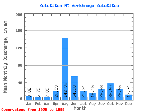
| Statistic | Jan | Feb | Mar | Apr | May | Jun | Jul | Aug | Sep | Oct | Nov | Dec | Annual |
|---|---|---|---|---|---|---|---|---|---|---|---|---|---|
| Mean | 8.81 | 6.84 | 7.09 | 20.39 | 142.87 | 54.98 | 21.24 | 15.15 | 25.88 | 38.60 | 25.66 | 12.74 | 380.57 |
| Standard Deviation | 1.93 | 1.01 | 0.96 | 27.25 | 45.33 | 42.16 | 11.60 | 11.17 | 17.17 | 20.64 | 15.10 | 5.18 | 86.34 |
| Min | 6.20 | 5.22 | 5.22 | 4.80 | 34.35 | 15.07 | 8.24 | 6.13 | 6.75 | 6.48 | 7.85 | 7.23 | 204.88 |
| Max | 13.04 | 9.28 | 9.36 | 114.39 | 237.24 | 192.99 | 54.58 | 61.56 | 75.79 | 81.36 | 62.12 | 32.31 | 536.72 |
| Coefficient of Variation | 0.22 | 0.15 | 0.14 | 1.34 | 0.32 | 0.77 | 0.55 | 0.74 | 0.66 | 0.54 | 0.59 | 0.41 | 0.23 |
 Return to R-Arctic Net Home Page