|
|
|||||||||||||||||
| Point ID: 7454 | Downloads | Plots | Site Data | Code: 70355 |
|
|
|||||||||||||||||
| Download | |
|---|---|
| Site Descriptor Information | Site Time Series Data |
| Link to all available data | |
|
|
| View: | Statistics | Time Series |
| Units: | mm |
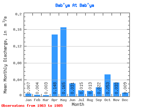
| Statistic | Jan | Feb | Mar | Apr | May | Jun | Jul | Aug | Sep | Oct | Nov | Dec | Annual |
|---|---|---|---|---|---|---|---|---|---|---|---|---|---|
| Mean | 0.01 | 0.00 | 0.00 | 0.15 | 0.17 | 0.03 | 0.01 | 0.01 | 0.02 | 0.05 | 0.03 | 0.01 | 0.05 |
| Standard Deviation | 0.01 | 0.00 | 0.00 | 0.08 | 0.09 | 0.03 | 0.02 | 0.02 | 0.03 | 0.04 | 0.03 | 0.01 | 0.02 |
| Min | 0.00 | 0.00 | 0.00 | 0.00 | 0.06 | 0.01 | 0.00 | 0.00 | 0.00 | 0.00 | 0.00 | 0.00 | 0.03 |
| Max | 0.03 | 0.01 | 0.01 | 0.27 | 0.30 | 0.11 | 0.07 | 0.07 | 0.09 | 0.11 | 0.09 | 0.02 | 0.08 |
| Coefficient of Variation | 1.23 | 0.91 | 0.76 | 0.53 | 0.52 | 0.92 | 1.25 | 1.47 | 1.15 | 0.69 | 0.97 | 0.73 | 0.39 |
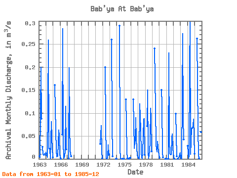
| Year | Jan | Feb | Mar | Apr | May | Jun | Jul | Aug | Sep | Oct | Nov | Dec | Annual | 1963 | 0.01 | 0.01 | 0.00 | 0.20 | 0.09 | 0.03 | 0.01 | 0.01 | 0.01 | 0.01 | 0.01 | 1964 | 0.01 | 0.01 | 0.00 | 0.11 | 0.26 | 0.02 | 0.02 | 0.00 | 0.04 | 0.08 | 0.04 | 0.00 | 0.05 | 1965 | 0.16 | 0.11 | 0.02 | 0.01 | 0.01 | 0.01 | 0.06 | 0.05 | 0.01 | 1966 | 0.01 | 0.00 | 0.05 | 0.28 | 0.04 | 0.00 | 0.00 | 0.01 | 0.11 | 0.02 | 1967 | 0.00 | 0.20 | 0.07 | 0.02 | 0.01 | 1971 | 0.03 | 0.07 | 0.02 | 0.00 | 1972 | 0.20 | 0.08 | 0.00 | 0.00 | 0.00 | 0.03 | 0.01 | 0.01 | 1973 | 0.26 | 0.08 | 0.01 | 0.00 | 0.00 | 1974 | 0.29 | 0.02 | 0.00 | 0.00 | 0.00 | 0.00 | 1975 | 0.00 | 0.13 | 0.08 | 0.01 | 0.00 | 0.00 | 0.00 | 0.00 | 0.00 | 1976 | 0.13 | 0.02 | 0.04 | 0.04 | 0.09 | 0.04 | 0.01 | 0.01 | 1977 | 0.00 | 0.00 | 0.00 | 0.12 | 0.06 | 0.01 | 0.00 | 0.00 | 0.01 | 0.09 | 0.09 | 0.01 | 0.03 | 1978 | 0.07 | 0.15 | 0.01 | 0.00 | 0.02 | 0.04 | 0.11 | 0.09 | 0.02 | 1979 | 0.24 | 0.11 | 0.03 | 0.02 | 0.02 | 0.04 | 0.02 | 0.01 | 1980 | 0.00 | 0.15 | 0.12 | 0.01 | 0.00 | 0.00 | 0.00 | 1981 | 0.00 | 0.00 | 0.23 | 0.04 | 0.01 | 0.01 | 0.01 | 0.05 | 0.05 | 0.02 | 1982 | 0.00 | 0.00 | 0.10 | 0.01 | 0.00 | 0.00 | 0.00 | 0.01 | 0.01 | 1983 | 0.00 | 0.00 | 0.00 | 0.27 | 0.09 | 0.04 | 1984 | 0.03 | 0.00 | 0.01 | 0.19 | 0.30 | 0.01 | 0.07 | 0.07 | 0.07 | 0.07 | 0.09 | 0.01 | 0.08 | 1985 | 0.26 | 0.07 | 0.01 | 0.00 | 0.01 | 0.07 | 0.06 | 0.02 |
|---|
 Return to R-Arctic Net Home Page