|
|
|||||||||||||||||
| Point ID: 7441 | Downloads | Plots | Site Data | Code: 70329 |
|
|
|||||||||||||||||
| Download | |
|---|---|
| Site Descriptor Information | Site Time Series Data |
| Link to all available data | |
|
|
| View: | Statistics | Time Series |
| Units: | mm |
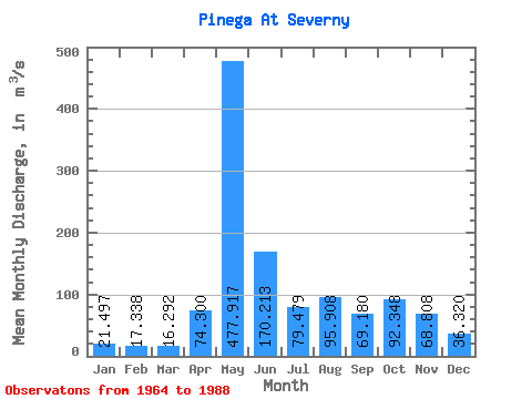
| Statistic | Jan | Feb | Mar | Apr | May | Jun | Jul | Aug | Sep | Oct | Nov | Dec | Annual |
|---|---|---|---|---|---|---|---|---|---|---|---|---|---|
| Mean | 21.50 | 17.34 | 16.29 | 74.30 | 477.92 | 170.21 | 79.48 | 95.91 | 69.18 | 92.35 | 68.81 | 36.32 | 101.03 |
| Standard Deviation | 6.06 | 4.53 | 3.77 | 96.20 | 129.31 | 67.22 | 47.16 | 200.78 | 34.81 | 42.24 | 33.87 | 16.76 | 22.40 |
| Min | 9.52 | 8.51 | 9.90 | 15.80 | 232.00 | 71.50 | 23.10 | 23.40 | 21.40 | 31.70 | 24.50 | 19.10 | 66.13 |
| Max | 36.90 | 25.40 | 28.30 | 435.00 | 726.00 | 330.00 | 208.00 | 1010.00 | 142.00 | 201.00 | 139.00 | 83.30 | 188.80 |
| Coefficient of Variation | 0.28 | 0.26 | 0.23 | 1.29 | 0.27 | 0.40 | 0.59 | 2.09 | 0.50 | 0.46 | 0.49 | 0.46 | 0.22 |
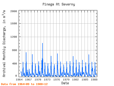
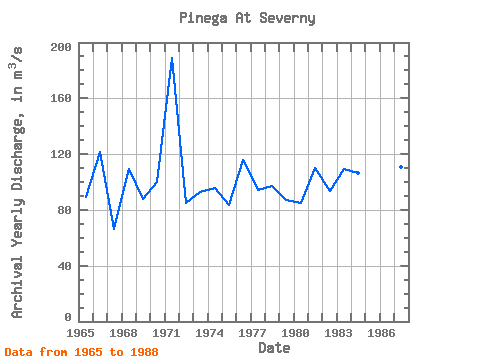
| Year | Jan | Feb | Mar | Apr | May | Jun | Jul | Aug | Sep | Oct | Nov | Dec | Annual | 1964 | 141.00 | 152.00 | 107.00 | 41.10 | 1965 | 30.20 | 24.20 | 28.30 | 46.00 | 439.00 | 120.00 | 69.10 | 37.70 | 29.90 | 97.90 | 120.00 | 29.30 | 89.30 | 1966 | 23.40 | 18.10 | 14.30 | 71.10 | 726.00 | 179.00 | 43.70 | 25.60 | 63.30 | 201.00 | 73.90 | 19.10 | 121.54 | 1967 | 9.52 | 8.51 | 9.90 | 162.00 | 232.00 | 71.50 | 42.90 | 28.90 | 41.30 | 65.80 | 93.60 | 27.60 | 66.13 | 1968 | 17.10 | 13.50 | 14.40 | 22.00 | 668.00 | 200.00 | 65.10 | 112.00 | 59.30 | 75.30 | 39.90 | 24.20 | 109.23 | 1969 | 19.20 | 12.00 | 12.20 | 39.00 | 389.00 | 139.00 | 93.30 | 51.80 | 87.00 | 71.50 | 62.10 | 81.30 | 88.12 | 1970 | 18.80 | 16.10 | 15.20 | 29.30 | 455.00 | 169.00 | 43.00 | 43.20 | 133.00 | 168.00 | 73.20 | 33.40 | 99.77 | 1971 | 25.40 | 24.00 | 16.20 | 24.90 | 488.00 | 330.00 | 108.00 | 1010.00 | 69.00 | 61.80 | 71.80 | 36.50 | 188.80 | 1972 | 19.60 | 15.80 | 15.70 | 28.40 | 427.00 | 245.00 | 51.10 | 25.60 | 21.40 | 67.70 | 44.70 | 54.70 | 84.72 | 1973 | 27.20 | 16.80 | 16.90 | 240.00 | 398.00 | 81.80 | 23.10 | 38.60 | 116.00 | 87.20 | 45.40 | 24.60 | 92.97 | 1974 | 21.40 | 18.80 | 19.40 | 31.20 | 621.00 | 269.00 | 38.30 | 24.50 | 28.00 | 31.70 | 24.90 | 20.00 | 95.68 | 1975 | 18.90 | 17.40 | 17.30 | 193.00 | 370.00 | 179.00 | 50.50 | 23.80 | 35.00 | 47.00 | 27.60 | 24.70 | 83.68 | 1976 | 20.10 | 15.60 | 13.50 | 27.80 | 695.00 | 242.00 | 186.00 | 52.40 | 51.40 | 44.80 | 24.50 | 20.20 | 116.11 | 1977 | 16.30 | 14.00 | 13.80 | 53.90 | 446.00 | 163.00 | 35.20 | 40.40 | 46.40 | 107.00 | 139.00 | 52.10 | 93.92 | 1978 | 27.30 | 19.70 | 15.70 | 39.60 | 363.00 | 234.00 | 107.00 | 66.00 | 62.80 | 122.00 | 79.60 | 31.20 | 97.33 | 1979 | 14.60 | 12.70 | 12.70 | 15.80 | 456.00 | 118.00 | 64.50 | 59.00 | 80.20 | 120.00 | 55.00 | 37.10 | 87.13 | 1980 | 20.10 | 16.60 | 17.20 | 72.70 | 463.00 | 174.00 | 62.00 | 28.10 | 49.20 | 44.10 | 38.60 | 31.00 | 84.72 | 1981 | 24.60 | 23.60 | 20.30 | 18.80 | 614.00 | 244.00 | 61.90 | 28.10 | 47.00 | 88.00 | 114.00 | 36.60 | 110.08 | 1982 | 19.70 | 16.40 | 17.20 | 40.50 | 508.00 | 86.10 | 44.70 | 24.20 | 76.70 | 74.60 | 133.00 | 83.30 | 93.70 | 1983 | 36.90 | 25.40 | 18.70 | 435.00 | 248.00 | 93.40 | 94.70 | 47.10 | 38.60 | 144.00 | 86.90 | 42.10 | 109.23 | 1984 | 31.50 | 24.50 | 22.00 | 57.70 | 498.00 | 77.30 | 92.00 | 117.00 | 142.00 | 105.00 | 78.90 | 33.30 | 106.60 | 1985 | 19.20 | 15.40 | 14.50 | 18.40 | 425.00 | 180.00 | 156.00 | 67.30 | 84.70 | 129.00 | 58.30 | 32.40 | 100.02 | 1986 | 22.80 | 20.90 | 18.40 | 70.90 | 664.00 | 133.00 | 68.50 | 23.40 | 49.10 | 67.90 | 47.30 | 44.90 | 102.59 | 1987 | 14.90 | 12.90 | 13.40 | 15.80 | 442.00 | 167.00 | 208.00 | 252.00 | 97.80 | 57.40 | 28.90 | 20.80 | 110.91 | 1988 | 17.20 | 13.20 | 13.80 | 29.40 | 435.00 | 190.00 | 98.90 | 75.10 | 79.40 | 78.00 | 52.10 | 26.50 | 92.38 |
|---|
 Return to R-Arctic Net Home Page