|
|
|||||||||||||||||
| Point ID: 7370 | Downloads | Plots | Site Data | Code: 70152 |
|
|
|||||||||||||||||
| Download | |
|---|---|
| Site Descriptor Information | Site Time Series Data |
| Link to all available data | |
|
|
| View: | Statistics | Time Series |
| Units: | mm |
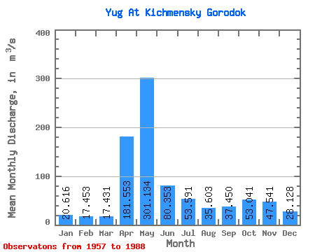
| Statistic | Jan | Feb | Mar | Apr | May | Jun | Jul | Aug | Sep | Oct | Nov | Dec | Annual |
|---|---|---|---|---|---|---|---|---|---|---|---|---|---|
| Mean | 20.62 | 17.45 | 17.43 | 181.55 | 301.13 | 80.35 | 53.59 | 35.60 | 37.45 | 53.04 | 47.54 | 28.13 | 72.83 |
| Standard Deviation | 6.31 | 3.63 | 4.50 | 106.74 | 153.30 | 54.70 | 39.37 | 24.95 | 20.36 | 27.83 | 27.24 | 13.84 | 16.86 |
| Min | 9.52 | 11.70 | 11.50 | 25.60 | 57.90 | 26.30 | 17.20 | 12.90 | 17.30 | 23.40 | 16.00 | 12.30 | 44.09 |
| Max | 39.30 | 25.90 | 36.30 | 472.00 | 580.00 | 265.00 | 163.00 | 124.00 | 96.40 | 113.00 | 122.00 | 75.90 | 111.76 |
| Coefficient of Variation | 0.31 | 0.21 | 0.26 | 0.59 | 0.51 | 0.68 | 0.73 | 0.70 | 0.54 | 0.53 | 0.57 | 0.49 | 0.23 |
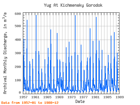
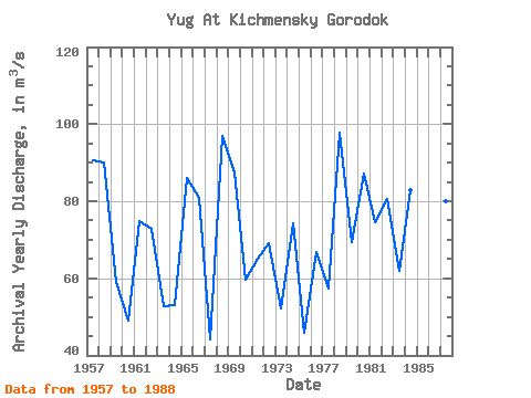
| Year | Jan | Feb | Mar | Apr | May | Jun | Jul | Aug | Sep | Oct | Nov | Dec | Annual | 1957 | 21.40 | 20.30 | 20.00 | 165.00 | 403.00 | 70.20 | 119.00 | 36.20 | 38.00 | 103.00 | 63.00 | 27.20 | 90.53 | 1958 | 26.50 | 24.10 | 24.10 | 122.00 | 542.00 | 155.00 | 32.40 | 23.10 | 22.80 | 50.00 | 36.10 | 21.20 | 89.94 | 1959 | 21.30 | 21.90 | 20.50 | 238.00 | 201.00 | 54.90 | 41.20 | 21.40 | 29.30 | 31.00 | 16.30 | 12.30 | 59.09 | 1960 | 13.60 | 15.00 | 16.20 | 254.00 | 115.00 | 30.60 | 25.70 | 12.90 | 25.10 | 38.30 | 25.80 | 16.80 | 49.08 | 1961 | 19.20 | 17.50 | 19.60 | 47.50 | 580.00 | 37.20 | 25.00 | 26.80 | 40.40 | 30.50 | 34.30 | 19.10 | 74.76 | 1962 | 16.70 | 15.50 | 15.80 | 313.00 | 261.00 | 35.20 | 24.50 | 30.40 | 46.10 | 33.10 | 58.00 | 26.30 | 72.97 | 1963 | 17.30 | 15.80 | 14.10 | 183.00 | 131.00 | 63.00 | 81.20 | 18.10 | 17.30 | 30.00 | 36.40 | 27.10 | 52.86 | 1964 | 22.30 | 19.10 | 16.50 | 118.00 | 252.00 | 42.80 | 22.80 | 21.90 | 26.10 | 39.60 | 38.60 | 17.90 | 53.13 | 1965 | 18.60 | 15.50 | 15.50 | 98.70 | 337.00 | 205.00 | 42.30 | 93.90 | 30.10 | 74.30 | 68.40 | 34.60 | 86.16 | 1966 | 27.60 | 18.80 | 20.70 | 472.00 | 261.00 | 39.70 | 17.20 | 17.10 | 24.80 | 36.80 | 23.10 | 12.40 | 80.93 | 1967 | 9.52 | 11.80 | 13.30 | 199.00 | 94.40 | 43.50 | 33.30 | 20.20 | 18.00 | 30.40 | 38.80 | 16.90 | 44.09 | 1968 | 14.10 | 12.20 | 15.30 | 163.00 | 446.00 | 56.60 | 91.80 | 83.70 | 72.20 | 113.00 | 61.50 | 32.90 | 96.86 | 1969 | 23.60 | 16.00 | 15.80 | 250.00 | 227.00 | 86.30 | 55.30 | 53.10 | 33.70 | 91.80 | 122.00 | 75.90 | 87.54 | 1970 | 24.10 | 18.50 | 16.60 | 176.00 | 233.00 | 84.10 | 33.00 | 23.50 | 25.80 | 34.60 | 26.00 | 20.80 | 59.67 | 1971 | 17.00 | 18.90 | 16.00 | 110.00 | 340.00 | 62.20 | 30.90 | 24.20 | 30.80 | 46.10 | 51.20 | 34.30 | 65.13 | 1972 | 24.80 | 14.60 | 14.00 | 161.00 | 381.00 | 75.90 | 30.40 | 22.50 | 25.70 | 32.20 | 22.50 | 24.70 | 69.11 | 1973 | 17.10 | 12.60 | 14.50 | 279.00 | 85.60 | 26.30 | 20.30 | 21.20 | 36.50 | 59.10 | 33.30 | 22.10 | 52.30 | 1974 | 16.30 | 14.70 | 16.20 | 31.70 | 578.00 | 101.00 | 24.20 | 23.00 | 22.00 | 23.40 | 23.70 | 16.40 | 74.22 | 1975 | 15.20 | 16.80 | 13.40 | 285.00 | 65.40 | 32.10 | 23.00 | 21.90 | 22.00 | 24.30 | 16.00 | 13.80 | 45.74 | 1976 | 12.40 | 11.70 | 11.50 | 99.10 | 360.00 | 123.00 | 62.00 | 30.50 | 25.40 | 26.60 | 21.90 | 18.00 | 66.84 | 1977 | 17.10 | 13.60 | 12.60 | 176.00 | 167.00 | 40.80 | 26.10 | 25.00 | 31.90 | 50.30 | 86.90 | 40.10 | 57.28 | 1978 | 26.20 | 19.00 | 15.20 | 207.00 | 211.00 | 265.00 | 83.90 | 56.70 | 79.10 | 102.00 | 68.30 | 40.40 | 97.82 | 1979 | 22.40 | 17.00 | 17.70 | 40.10 | 480.00 | 64.80 | 44.00 | 25.20 | 25.30 | 41.00 | 32.10 | 23.60 | 69.43 | 1980 | 17.60 | 16.70 | 15.10 | 190.00 | 388.00 | 60.40 | 114.00 | 27.80 | 64.30 | 64.60 | 53.60 | 34.70 | 87.23 | 1981 | 27.40 | 25.90 | 21.00 | 25.60 | 564.00 | 74.90 | 24.10 | 22.80 | 21.90 | 31.70 | 31.70 | 24.50 | 74.62 | 1982 | 17.80 | 15.00 | 15.80 | 133.00 | 390.00 | 97.60 | 54.50 | 24.20 | 31.90 | 38.20 | 97.00 | 52.00 | 80.58 | 1983 | 35.50 | 23.40 | 36.30 | 321.00 | 57.90 | 41.90 | 26.60 | 17.20 | 19.70 | 61.00 | 47.00 | 55.40 | 61.91 | 1984 | 39.30 | 19.00 | 19.20 | 204.00 | 204.00 | 38.70 | 150.00 | 40.10 | 50.80 | 101.00 | 105.00 | 22.20 | 82.78 | 1985 | 14.90 | 18.80 | 17.00 | 91.60 | 286.00 | 176.00 | 163.00 | 124.00 | 75.70 | 58.30 | 45.40 | 29.60 | 91.69 | 1986 | 22.00 | 19.50 | 20.00 | 426.00 | 243.00 | 126.00 | 101.00 | 50.00 | 96.40 | 112.00 | 82.50 | 42.70 | 111.76 | 1987 | 22.00 | 23.40 | 21.30 | 60.40 | 453.00 | 91.60 | 63.20 | 63.90 | 62.00 | 55.10 | 23.70 | 20.30 | 79.99 | 1988 | 18.90 | 15.90 | 17.00 | 170.00 | 299.00 | 69.00 | 29.00 | 36.80 | 27.30 | 34.00 | 31.20 | 23.90 | 64.33 |
|---|
 Return to R-Arctic Net Home Page