|
|
|||||||||||||||||
| Point ID: 729 | Downloads | Plots | Site Data | Code: 07FD003 |
|
|
|||||||||||||||||
| Download | |
|---|---|
| Site Descriptor Information | Site Time Series Data |
| Link to all available data | |
|
|
| View: | Statistics | Time Series |
| Units: | mm |
| Statistic | Jan | Feb | Mar | Apr | May | Jun | Jul | Aug | Sep | Oct | Nov | Dec | Annual |
|---|---|---|---|---|---|---|---|---|---|---|---|---|---|
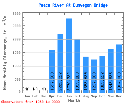
| Mean | 1597.50 | 2203.22 | 2770.72 | 1999.89 | 1353.64 | 1237.39 | 1365.62 | 1643.83 | 1804.00 | ||||
| Standard Deviation | 283.94 | 812.75 | 1878.67 | 1277.87 | 756.92 | 364.59 | 292.32 | 384.60 | 197.69 | ||||
| Min | 1200.00 | 836.00 | 996.00 | 674.00 | 351.00 | 335.00 | 426.00 | 923.00 | 1490.00 | ||||
| Max | 1830.00 | 4260.00 | 8820.00 | 6410.00 | 3560.00 | 2300.00 | 1910.00 | 2030.00 | 2010.00 | ||||
| Coefficient of Variation | 0.18 | 0.37 | 0.68 | 0.64 | 0.56 | 0.29 | 0.21 | 0.23 | 0.11 |
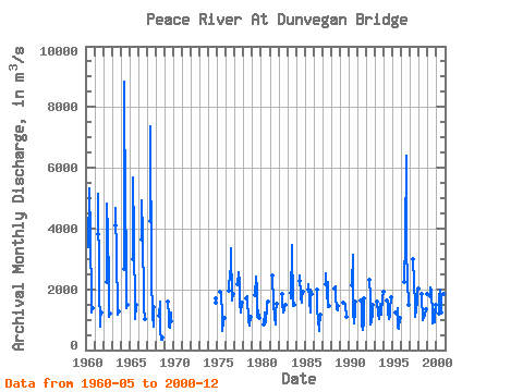
| Year | Jan | Feb | Mar | Apr | May | Jun | Jul | Aug | Sep | Oct | Nov | Dec | Annual | 1960 | 3370.00 | 5340.00 | 3760.00 | 1640.00 | 1240.00 | 1370.00 | 1961 | 3800.00 | 5130.00 | 2080.00 | 759.00 | 1020.00 | 1220.00 | 1962 | 2240.00 | 4820.00 | 3840.00 | 2320.00 | 1080.00 | 1190.00 | 1963 | 4110.00 | 4680.00 | 3000.00 | 1460.00 | 1150.00 | 1260.00 | 1964 | 2680.00 | 8820.00 | 4330.00 | 3560.00 | 1380.00 | 1470.00 | 1965 | 3000.00 | 5690.00 | 3750.00 | 1150.00 | 1020.00 | 1480.00 | 1966 | 3630.00 | 4930.00 | 3790.00 | 1670.00 | 1430.00 | 1010.00 | 1967 | 4260.00 | 7370.00 | 2420.00 | 1120.00 | 780.00 | 1400.00 | 1968 | 1120.00 | 1580.00 | 674.00 | 351.00 | 335.00 | 426.00 | 1969 | 1610.00 | 1130.00 | 756.00 | 729.00 | 1230.00 | 952.00 | 1974 | 1690.00 | 1570.00 | 1975 | 1900.00 | 1840.00 | 1120.00 | 636.00 | 941.00 | 1050.00 | 1976 | 1970.00 | 2610.00 | 2490.00 | 3360.00 | 1630.00 | 1860.00 | 1977 | 2170.00 | 2550.00 | 2200.00 | 1570.00 | 1230.00 | 1560.00 | 1978 | 1710.00 | 1760.00 | 938.00 | 934.00 | 809.00 | 1080.00 | 1979 | 1820.00 | 2410.00 | 2020.00 | 1110.00 | 1310.00 | 1070.00 | 1980 | 836.00 | 1250.00 | 919.00 | 930.00 | 1460.00 | 1580.00 | 1981 | 2460.00 | 1570.00 | 1100.00 | 847.00 | 1280.00 | 1520.00 | 1982 | 1850.00 | 1510.00 | 1230.00 | 1310.00 | 1330.00 | 1490.00 | 1983 | 1870.00 | 1690.00 | 3460.00 | 1450.00 | 1620.00 | 1470.00 | 1984 | 2290.00 | 2450.00 | 1730.00 | 1560.00 | 1720.00 | 1910.00 | 1985 | 1980.00 | 2170.00 | 1640.00 | 1220.00 | 1980.00 | 1830.00 | 1986 | 1980.00 | 1350.00 | 983.00 | 625.00 | 745.00 | 1180.00 | 1987 | 2160.00 | 2510.00 | 1710.00 | 2230.00 | 1430.00 | 1450.00 | 1988 | 2010.00 | 2090.00 | 1790.00 | 1340.00 | 1320.00 | 1440.00 | 1989 | 1570.00 | 1570.00 | 1570.00 | 1480.00 | 1110.00 | 1100.00 | 1990 | 2130.00 | 3140.00 | 1240.00 | 893.00 | 1270.00 | 1590.00 | 1991 | 1620.00 | 1540.00 | 828.00 | 670.00 | 867.00 | 1710.00 | 1992 | 2300.00 | 1730.00 | 848.00 | 948.00 | 1180.00 | 1480.00 | 1993 | 1590.00 | 1180.00 | 1010.00 | 1300.00 | 1510.00 | 1280.00 | 1180.00 | 1750.00 | 1910.00 | 1994 | 1620.00 | 1540.00 | 1270.00 | 1020.00 | 1080.00 | 1350.00 | 1730.00 | 1995 | 1250.00 | 1170.00 | 1390.00 | 747.00 | 709.00 | 1040.00 | 1996 | 2250.00 | 3640.00 | 6410.00 | 3310.00 | 2300.00 | 1500.00 | 1997 | 2980.00 | 2240.00 | 1440.00 | 1090.00 | 1310.00 | 1640.00 | 2030.00 | 2010.00 | 1998 | 1830.00 | 1790.00 | 996.00 | 1070.00 | 1060.00 | 1120.00 | 1360.00 | 1850.00 | 1999 | 1770.00 | 2060.00 | 1920.00 | 1180.00 | 882.00 | 1260.00 | 1350.00 | 923.00 | 1490.00 | 2000 | 1200.00 | 1740.00 | 2000.00 | 1720.00 | 1240.00 | 1590.00 | 1270.00 | 1860.00 | 1760.00 |
|---|
 Return to R-Arctic Net Home Page