|
|
|||||||||||||||||
| Point ID: 7265 | Downloads | Plots | Site Data | Code: 49004 |
|
|
|||||||||||||||||
| Download | |
|---|---|
| Site Descriptor Information | Site Time Series Data |
| Link to all available data | |
|
|
| View: | Statistics | Time Series |
| Units: | mm |
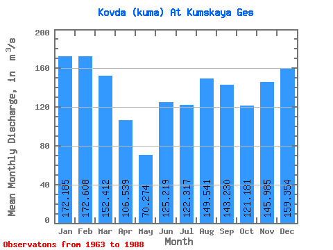
| Statistic | Jan | Feb | Mar | Apr | May | Jun | Jul | Aug | Sep | Oct | Nov | Dec | Annual |
|---|---|---|---|---|---|---|---|---|---|---|---|---|---|
| Mean | 172.19 | 172.61 | 152.41 | 106.54 | 70.27 | 125.22 | 122.32 | 149.54 | 143.23 | 121.18 | 145.99 | 159.35 | 136.74 |
| Standard Deviation | 47.06 | 59.62 | 47.97 | 59.69 | 66.42 | 95.06 | 69.42 | 66.88 | 65.79 | 51.99 | 54.76 | 45.80 | 33.02 |
| Min | 80.60 | 52.90 | 46.60 | 3.34 | 2.41 | 1.70 | 2.49 | 9.77 | 9.45 | 19.30 | 32.50 | 25.40 | 74.13 |
| Max | 237.00 | 257.00 | 236.00 | 246.00 | 309.00 | 374.00 | 242.00 | 252.00 | 247.00 | 195.00 | 243.00 | 236.00 | 201.58 |
| Coefficient of Variation | 0.27 | 0.34 | 0.32 | 0.56 | 0.94 | 0.76 | 0.57 | 0.45 | 0.46 | 0.43 | 0.38 | 0.29 | 0.24 |
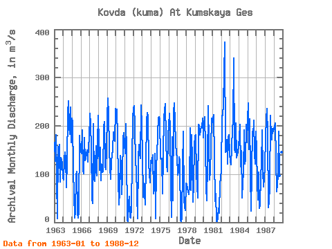
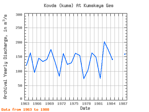
| Year | Jan | Feb | Mar | Apr | May | Jun | Jul | Aug | Sep | Oct | Nov | Dec | Annual | 1963 | 165.00 | 127.00 | 182.00 | 89.20 | 8.19 | 157.00 | 112.00 | 162.00 | 83.50 | 134.00 | 123.00 | 90.60 | 119.46 | 1964 | 87.70 | 132.00 | 145.00 | 133.00 | 72.80 | 128.00 | 226.00 | 252.00 | 197.00 | 183.00 | 238.00 | 166.00 | 163.38 | 1965 | 216.00 | 208.00 | 107.00 | 9.67 | 21.50 | 96.30 | 106.00 | 19.80 | 9.45 | 22.00 | 180.00 | 146.00 | 95.14 | 1966 | 151.00 | 142.00 | 191.00 | 108.00 | 101.00 | 175.00 | 128.00 | 132.00 | 150.00 | 125.00 | 163.00 | 170.00 | 144.67 | 1967 | 226.00 | 204.00 | 154.00 | 49.50 | 39.40 | 205.00 | 90.20 | 85.60 | 118.00 | 159.00 | 96.40 | 166.00 | 132.76 | 1968 | 222.00 | 108.00 | 155.00 | 86.20 | 119.00 | 104.00 | 106.00 | 199.00 | 208.00 | 117.00 | 109.00 | 153.00 | 140.52 | 1969 | 219.00 | 257.00 | 225.00 | 152.00 | 113.00 | 89.90 | 127.00 | 150.00 | 187.00 | 174.00 | 168.00 | 236.00 | 174.82 | 1970 | 218.00 | 234.00 | 176.00 | 87.90 | 36.60 | 64.50 | 139.00 | 119.00 | 58.50 | 95.00 | 175.00 | 186.00 | 132.46 | 1971 | 143.00 | 204.00 | 150.00 | 3.34 | 2.41 | 41.40 | 54.20 | 10.50 | 9.52 | 29.70 | 131.00 | 214.00 | 82.76 | 1972 | 237.00 | 241.00 | 198.00 | 126.00 | 108.00 | 8.41 | 132.00 | 161.00 | 143.00 | 133.00 | 243.00 | 198.00 | 160.70 | 1973 | 142.00 | 52.90 | 80.80 | 59.20 | 37.20 | 123.00 | 210.00 | 227.00 | 218.00 | 121.00 | 81.80 | 128.00 | 123.41 | 1974 | 122.00 | 128.00 | 140.00 | 60.10 | 67.70 | 143.00 | 7.58 | 121.00 | 137.00 | 184.00 | 217.00 | 219.00 | 128.87 | 1975 | 214.00 | 133.00 | 131.00 | 132.00 | 60.00 | 219.00 | 231.00 | 246.00 | 175.00 | 119.00 | 105.00 | 179.00 | 162.00 | 1976 | 201.00 | 226.00 | 196.00 | 77.80 | 11.40 | 177.00 | 44.70 | 229.00 | 247.00 | 167.00 | 140.00 | 137.00 | 154.49 | 1977 | 98.50 | 104.00 | 136.00 | 127.00 | 4.02 | 2.18 | 9.28 | 115.00 | 189.00 | 46.70 | 32.50 | 25.40 | 74.13 | 1978 | 80.60 | 79.40 | 69.30 | 58.20 | 76.10 | 196.00 | 66.20 | 182.00 | 131.00 | 43.00 | 79.70 | 159.00 | 101.71 | 1979 | 178.00 | 182.00 | 101.00 | 74.90 | 50.90 | 203.00 | 200.00 | 181.00 | 198.00 | 195.00 | 216.00 | 176.00 | 162.98 | 1980 | 203.00 | 219.00 | 160.00 | 72.30 | 45.20 | 122.00 | 242.00 | 163.00 | 88.60 | 107.00 | 154.00 | 216.00 | 149.34 | 1981 | 207.00 | 223.00 | 133.00 | 43.70 | 58.80 | 1.70 | 2.49 | 9.77 | 29.40 | 19.30 | 82.70 | 90.20 | 75.09 | 1982 | 109.00 | 221.00 | 222.00 | 246.00 | 309.00 | 374.00 | 145.00 | 171.00 | 121.00 | 177.00 | 182.00 | 142.00 | 201.58 | 1983 | 125.00 | 119.00 | 155.00 | 194.00 | 208.00 | 341.00 | 153.00 | 145.00 | 206.00 | 134.00 | 141.00 | 144.00 | 172.08 | 1984 | 175.00 | 203.00 | 116.00 | 148.00 | 51.00 | 83.90 | 101.00 | 191.00 | 121.00 | 130.00 | 203.00 | 166.00 | 140.74 | 1985 | 215.00 | 247.00 | 151.00 | 214.00 | 102.00 | 24.10 | 189.00 | 178.00 | 211.00 | 143.00 | 121.00 | 188.00 | 165.26 | 1986 | 150.00 | 81.50 | 46.60 | 104.00 | 29.70 | 35.40 | 96.20 | 120.00 | 192.00 | 107.00 | 74.50 | 112.00 | 95.74 | 1987 | 178.00 | 213.00 | 236.00 | 183.00 | 31.10 | 43.50 | 74.40 | 221.00 | 175.00 | 171.00 | 194.00 | 188.00 | 159.00 | 1988 | 194.00 | 199.00 | 206.00 | 131.00 | 63.10 | 97.40 | 188.00 | 97.40 | 121.00 | 115.00 | 145.00 | 148.00 | 142.07 |
|---|
 Return to R-Arctic Net Home Page