|
|
|||||||||||||||||
| Point ID: 7234 | Downloads | Plots | Site Data | Code: 12413 |
|
|
|||||||||||||||||
| Download | |
|---|---|
| Site Descriptor Information | Site Time Series Data |
| Link to all available data | |
|
|
| View: | Statistics | Time Series |
| Units: | mm |
| Statistic | Jan | Feb | Mar | Apr | May | Jun | Jul | Aug | Sep | Oct | Nov | Dec | Annual |
|---|---|---|---|---|---|---|---|---|---|---|---|---|---|
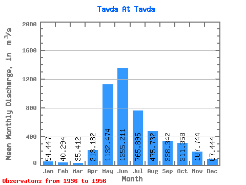
| Mean | 54.45 | 40.29 | 35.41 | 213.18 | 1132.47 | 1355.21 | 765.89 | 475.73 | 338.34 | 311.36 | 187.74 | 87.44 | 439.21 |
| Standard Deviation | 20.44 | 16.20 | 16.13 | 195.12 | 533.58 | 709.73 | 464.69 | 501.45 | 321.95 | 187.19 | 100.29 | 40.15 | 211.08 |
| Min | 28.00 | 24.30 | 18.60 | 26.10 | 421.00 | 533.00 | 189.00 | 64.70 | 47.30 | 33.50 | 54.90 | 35.30 | 189.51 |
| Max | 96.30 | 78.70 | 72.00 | 688.00 | 2110.00 | 2730.00 | 1730.00 | 2290.00 | 1370.00 | 679.00 | 417.00 | 163.00 | 962.92 |
| Coefficient of Variation | 0.38 | 0.40 | 0.46 | 0.92 | 0.47 | 0.52 | 0.61 | 1.05 | 0.95 | 0.60 | 0.53 | 0.46 | 0.48 |
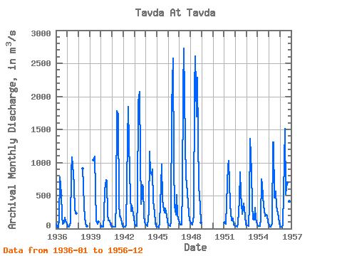
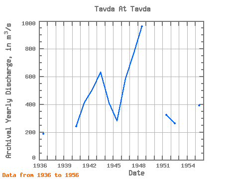
| Year | Jan | Feb | Mar | Apr | May | Jun | Jul | Aug | Sep | Oct | Nov | Dec | Annual | 1936 | 71.10 | 26.50 | 18.60 | 140.00 | 778.00 | 533.00 | 189.00 | 73.20 | 88.00 | 166.00 | 114.00 | 76.70 | 189.51 | 1937 | 43.00 | 30.80 | 27.70 | 86.20 | 854.00 | 1080.00 | 829.00 | 645.00 | 269.00 | 227.00 | 1938 | 906.00 | 658.00 | 318.00 | 64.70 | 47.30 | 33.50 | 1939 | 1040.00 | 1090.00 | 583.00 | 111.00 | 71.20 | 98.30 | 1940 | 32.90 | 28.60 | 29.40 | 212.00 | 584.00 | 737.00 | 712.00 | 210.00 | 123.00 | 121.00 | 58.00 | 41.70 | 240.80 | 1941 | 34.70 | 29.50 | 26.20 | 26.10 | 423.00 | 1780.00 | 1730.00 | 386.00 | 190.00 | 183.00 | 87.30 | 39.10 | 411.24 | 1942 | 36.30 | 26.60 | 24.10 | 51.50 | 1330.00 | 1840.00 | 1290.00 | 474.00 | 263.00 | 345.00 | 286.00 | 152.00 | 509.88 | 1943 | 78.30 | 44.10 | 40.20 | 427.00 | 1920.00 | 2070.00 | 1070.00 | 368.00 | 659.00 | 620.00 | 201.00 | 92.30 | 632.49 | 1944 | 61.60 | 43.30 | 37.10 | 259.00 | 1170.00 | 854.00 | 812.00 | 899.00 | 414.00 | 251.00 | 85.70 | 35.30 | 410.17 | 1945 | 28.00 | 25.20 | 19.60 | 91.90 | 656.00 | 974.00 | 439.00 | 280.00 | 239.00 | 311.00 | 200.00 | 112.00 | 281.31 | 1946 | 62.80 | 45.10 | 37.60 | 108.00 | 1860.00 | 2570.00 | 974.00 | 336.00 | 209.00 | 516.00 | 204.00 | 121.00 | 586.96 | 1947 | 81.70 | 62.70 | 63.20 | 592.00 | 2080.00 | 2730.00 | 1320.00 | 767.00 | 683.00 | 390.00 | 224.00 | 133.00 | 760.55 | 1948 | 77.70 | 68.50 | 61.30 | 203.00 | 2110.00 | 2610.00 | 1690.00 | 2290.00 | 1370.00 | 635.00 | 343.00 | 96.60 | 962.92 | 1951 | 96.30 | 78.70 | 72.00 | 688.00 | 940.00 | 1030.00 | 371.00 | 234.00 | 127.00 | 159.00 | 54.90 | 46.70 | 324.80 | 1952 | 38.80 | 35.10 | 30.60 | 83.50 | 421.00 | 850.00 | 531.00 | 219.00 | 311.00 | 378.00 | 198.00 | 63.80 | 263.32 | 1953 | 47.20 | 45.10 | 40.40 | 361.00 | 1360.00 | 865.00 | 362.00 | 146.00 | 135.00 | 312.00 | 145.00 | 59.70 | 323.20 | 1954 | 53.10 | 41.70 | 33.20 | 159.00 | 745.00 | 658.00 | 338.00 | 275.00 | 185.00 | 208.00 | 204.00 | 90.30 | 249.19 | 1955 | 43.60 | 29.20 | 22.20 | 75.10 | 1310.00 | 1310.00 | 473.00 | 565.00 | 333.00 | 283.00 | 182.00 | 75.90 | 391.83 | 1956 | 38.50 | 24.30 | 18.60 | 60.80 | 1030.00 | 1510.00 | 521.00 | 696.00 | 712.00 | 679.00 | 417.00 | 163.00 | 489.18 |
|---|
 Return to R-Arctic Net Home Page