|
|
|||||||||||||||||
| Point ID: 7233 | Downloads | Plots | Site Data | Code: 12412 |
|
|
|||||||||||||||||
| Download | |
|---|---|
| Site Descriptor Information | Site Time Series Data |
| Link to all available data | |
|
|
| View: | Statistics | Time Series |
| Units: | mm |
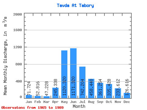
| Statistic | Jan | Feb | Mar | Apr | May | Jun | Jul | Aug | Sep | Oct | Nov | Dec | Annual |
|---|---|---|---|---|---|---|---|---|---|---|---|---|---|
| Mean | 71.72 | 52.82 | 47.23 | 245.34 | 1120.32 | 1171.32 | 742.20 | 458.44 | 361.25 | 335.43 | 233.61 | 126.62 | 410.46 |
| Standard Deviation | 30.38 | 18.47 | 15.16 | 155.31 | 383.69 | 459.49 | 460.68 | 392.61 | 268.17 | 246.14 | 182.41 | 83.92 | 148.29 |
| Min | 24.40 | 17.50 | 20.00 | 66.80 | 353.00 | 273.00 | 86.10 | 124.00 | 98.10 | 73.60 | 51.80 | 46.10 | 172.30 |
| Max | 132.00 | 87.50 | 76.70 | 727.00 | 1610.00 | 1870.00 | 1580.00 | 1470.00 | 1010.00 | 1140.00 | 808.00 | 429.00 | 653.62 |
| Coefficient of Variation | 0.42 | 0.35 | 0.32 | 0.63 | 0.34 | 0.39 | 0.62 | 0.86 | 0.74 | 0.73 | 0.78 | 0.66 | 0.36 |
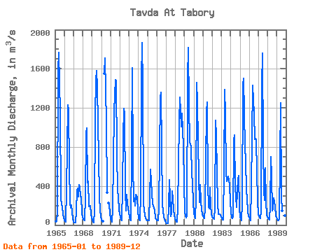
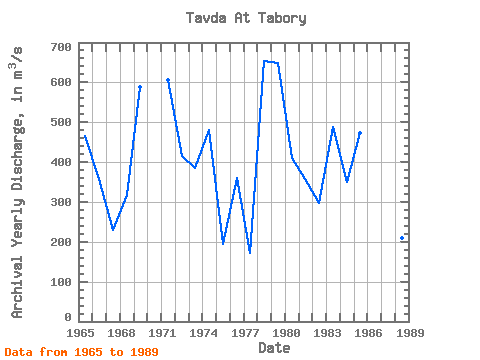
| Year | Jan | Feb | Mar | Apr | May | Jun | Jul | Aug | Sep | Oct | Nov | Dec | Annual | 1965 | 42.50 | 30.90 | 38.90 | 126.00 | 1580.00 | 1770.00 | 1150.00 | 279.00 | 204.00 | 192.00 | 107.00 | 72.50 | 466.07 | 1966 | 48.70 | 36.70 | 29.80 | 362.00 | 1230.00 | 1170.00 | 606.00 | 225.00 | 179.00 | 203.00 | 134.00 | 66.20 | 357.53 | 1967 | 31.30 | 25.60 | 23.50 | 146.00 | 353.00 | 374.00 | 287.00 | 413.00 | 390.00 | 290.00 | 291.00 | 116.00 | 228.37 | 1968 | 52.00 | 51.00 | 46.20 | 290.00 | 940.00 | 992.00 | 431.00 | 449.00 | 187.00 | 195.00 | 114.00 | 70.90 | 318.18 | 1969 | 52.90 | 31.00 | 25.80 | 138.00 | 1120.00 | 1490.00 | 1580.00 | 1410.00 | 688.00 | 295.00 | 142.00 | 94.00 | 588.89 | 1970 | 47.50 | 43.20 | 40.30 | 1550.00 | 1710.00 | 1060.00 | 335.00 | 227.00 | 209.00 | 116.00 | 1971 | 65.60 | 43.10 | 35.20 | 165.00 | 1150.00 | 1340.00 | 1490.00 | 1470.00 | 731.00 | 363.00 | 280.00 | 153.00 | 607.16 | 1972 | 109.00 | 56.60 | 45.80 | 381.00 | 901.00 | 1190.00 | 1140.00 | 352.00 | 147.00 | 311.00 | 209.00 | 128.00 | 414.20 | 1973 | 81.10 | 51.40 | 43.90 | 727.00 | 1610.00 | 650.00 | 238.00 | 279.00 | 199.00 | 310.00 | 290.00 | 131.00 | 384.20 | 1974 | 75.00 | 50.80 | 43.60 | 322.00 | 1480.00 | 1870.00 | 1420.00 | 222.00 | 98.10 | 73.60 | 54.50 | 46.10 | 479.64 | 1975 | 43.40 | 46.60 | 45.20 | 306.00 | 570.00 | 444.00 | 215.00 | 201.00 | 170.00 | 152.00 | 68.90 | 59.50 | 193.47 | 1976 | 47.10 | 48.20 | 47.00 | 162.00 | 1310.00 | 1360.00 | 790.00 | 228.00 | 133.00 | 90.10 | 51.80 | 49.00 | 359.68 | 1977 | 24.40 | 17.50 | 20.00 | 194.00 | 463.00 | 273.00 | 86.10 | 124.00 | 345.00 | 263.00 | 162.00 | 95.60 | 172.30 | 1978 | 48.70 | 32.40 | 33.50 | 185.00 | 613.00 | 1050.00 | 1310.00 | 1170.00 | 1010.00 | 1140.00 | 808.00 | 429.00 | 652.47 | 1979 | 132.00 | 87.50 | 76.70 | 97.00 | 1510.00 | 1820.00 | 1220.00 | 853.00 | 806.00 | 524.00 | 433.00 | 225.00 | 648.68 | 1980 | 128.00 | 84.60 | 68.10 | 270.00 | 1460.00 | 1260.00 | 478.00 | 236.00 | 415.00 | 241.00 | 158.00 | 111.00 | 409.14 | 1981 | 90.30 | 77.40 | 71.60 | 166.00 | 1160.00 | 1260.00 | 407.00 | 189.00 | 166.00 | 386.00 | 192.00 | 120.00 | 357.11 | 1982 | 80.20 | 66.50 | 63.10 | 175.00 | 1070.00 | 922.00 | 533.00 | 218.00 | 111.00 | 113.00 | 109.00 | 95.40 | 296.35 | 1983 | 70.90 | 56.30 | 51.80 | 564.00 | 1390.00 | 1130.00 | 543.00 | 449.00 | 471.00 | 495.00 | 409.00 | 232.00 | 488.50 | 1984 | 130.00 | 78.10 | 65.30 | 89.30 | 869.00 | 920.00 | 385.00 | 180.00 | 344.00 | 469.00 | 508.00 | 172.00 | 350.81 | 1985 | 81.80 | 60.60 | 48.50 | 220.00 | 1430.00 | 1500.00 | 802.00 | 660.00 | 351.00 | 275.00 | 139.00 | 92.90 | 471.73 | 1986 | 75.20 | 61.20 | 47.00 | 387.00 | 1430.00 | 1270.00 | 1140.00 | 876.00 | 886.00 | 878.00 | 542.00 | 251.00 | 653.62 | 1987 | 107.00 | 74.30 | 68.10 | 147.00 | 1430.00 | 1760.00 | 798.00 | 337.00 | 252.00 | 583.00 | 244.00 | 99.00 | 491.62 | 1988 | 67.10 | 59.00 | 52.00 | 202.00 | 701.00 | 508.00 | 146.00 | 160.00 | 273.00 | 190.00 | 87.00 | 75.00 | 210.01 | 1989 | 61.40 | 49.90 | 49.80 | 66.80 | 688.00 | 1250.00 | 300.00 | 146.00 | 114.00 | 127.00 | 98.10 | 65.30 | 251.36 |
|---|
 Return to R-Arctic Net Home Page