|
|
|||||||||||||||||
| Point ID: 7206 | Downloads | Plots | Site Data | Code: 12223 |
|
|
|||||||||||||||||
| Download | |
|---|---|
| Site Descriptor Information | Site Time Series Data |
| Link to all available data | |
| View: | Time Series | All |
| Units: | mm |
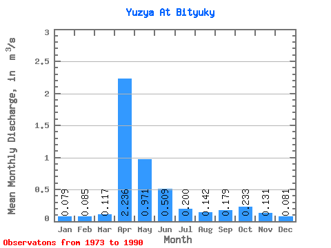
| Statistic | Jan | Feb | Mar | Apr | May | Jun | Jul | Aug | Sep | Oct | Nov | Dec | Annual |
|---|---|---|---|---|---|---|---|---|---|---|---|---|---|
| Mean | 0.08 | 0.09 | 0.12 | 2.24 | 0.97 | 0.51 | 0.20 | 0.14 | 0.18 | 0.23 | 0.13 | 0.08 | 0.46 |
| Standard Deviation | 0.04 | 0.06 | 0.07 | 1.88 | 0.72 | 0.81 | 0.17 | 0.07 | 0.20 | 0.29 | 0.06 | 0.06 | 0.27 |
| Min | 0.00 | 0.00 | 0.04 | 0.46 | 0.26 | 0.12 | 0.08 | 0.06 | 0.08 | 0.09 | 0.07 | 0.00 | 0.15 |
| Max | 0.20 | 0.25 | 0.27 | 6.40 | 2.95 | 3.56 | 0.76 | 0.31 | 0.91 | 1.32 | 0.32 | 0.25 | 0.95 |
| Coefficient of Variation | 0.54 | 0.68 | 0.58 | 0.84 | 0.74 | 1.59 | 0.85 | 0.52 | 1.10 | 1.25 | 0.48 | 0.74 | 0.60 |
 Return to R-Arctic Net Home Page