|
|
|||||||||||||||||
| Point ID: 7184 | Downloads | Plots | Site Data | Other Close Sites | Code: 12127 |
|
|
|||||||||||||||||
| Download | |
|---|---|
| Site Descriptor Information | Site Time Series Data |
| Link to all available data | |
|
|
| View: | Statistics | Time Series |
| Units: | mm |
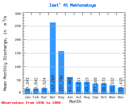
| Statistic | Jan | Feb | Mar | Apr | May | Jun | Jul | Aug | Sep | Oct | Nov | Dec | Annual |
|---|---|---|---|---|---|---|---|---|---|---|---|---|---|
| Mean | 19.34 | 18.84 | 20.52 | 263.27 | 157.79 | 61.48 | 43.21 | 43.01 | 37.17 | 38.67 | 31.53 | 23.41 | 64.89 |
| Standard Deviation | 8.45 | 8.30 | 8.92 | 204.13 | 157.24 | 43.11 | 25.75 | 30.69 | 22.48 | 29.94 | 20.16 | 11.50 | 34.36 |
| Min | 5.71 | 4.03 | 3.77 | 35.00 | 25.60 | 15.00 | 9.47 | 11.50 | 8.63 | 6.00 | 12.50 | 9.63 | 18.79 |
| Max | 46.90 | 41.00 | 43.60 | 904.00 | 961.00 | 266.00 | 151.00 | 155.00 | 119.00 | 184.00 | 102.00 | 60.30 | 161.17 |
| Coefficient of Variation | 0.44 | 0.44 | 0.43 | 0.78 | 1.00 | 0.70 | 0.60 | 0.71 | 0.60 | 0.77 | 0.64 | 0.49 | 0.53 |
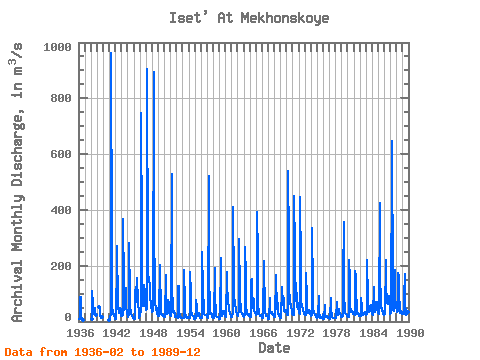
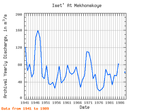
| Year | Jan | Feb | Mar | Apr | May | Jun | Jul | Aug | Sep | Oct | Nov | Dec | Annual | 1936 | 7.52 | 7.87 | 87.00 | 87.70 | 16.50 | 9.47 | 11.50 | 8.63 | 6.00 | 1938 | 9.80 | 109.00 | 61.60 | 32.20 | 26.50 | 49.80 | 24.90 | 23.20 | 24.70 | 1939 | 53.50 | 37.10 | 22.10 | 13.20 | 15.70 | 16.30 | 1941 | 5.71 | 4.03 | 3.77 | 35.00 | 961.00 | 266.00 | 44.90 | 39.30 | 26.80 | 25.20 | 22.00 | 13.80 | 120.63 | 1942 | 9.28 | 9.60 | 12.00 | 220.00 | 272.00 | 54.20 | 43.50 | 37.50 | 30.30 | 48.90 | 40.40 | 19.60 | 66.44 | 1943 | 18.00 | 20.40 | 24.10 | 367.00 | 122.00 | 39.80 | 62.20 | 86.80 | 119.00 | 54.90 | 32.20 | 27.70 | 81.17 | 1944 | 22.20 | 17.90 | 21.70 | 283.00 | 91.80 | 56.70 | 27.80 | 28.50 | 21.80 | 21.80 | 14.20 | 11.30 | 51.56 | 1945 | 8.81 | 8.13 | 9.11 | 102.00 | 123.00 | 69.30 | 70.40 | 155.00 | 72.20 | 67.90 | 28.70 | 12.40 | 60.58 | 1946 | 22.70 | 30.60 | 33.80 | 746.00 | 300.00 | 106.00 | 56.20 | 78.40 | 62.50 | 130.00 | 102.00 | 60.30 | 144.04 | 1947 | 46.90 | 41.00 | 43.60 | 904.00 | 191.00 | 170.00 | 151.00 | 123.00 | 82.00 | 68.80 | 55.80 | 35.40 | 159.38 | 1948 | 36.30 | 39.40 | 36.80 | 895.00 | 373.00 | 78.40 | 60.90 | 55.90 | 42.10 | 47.00 | 25.60 | 20.50 | 142.57 | 1949 | 19.30 | 20.10 | 26.70 | 202.00 | 171.00 | 54.20 | 28.40 | 23.20 | 25.40 | 24.40 | 19.20 | 14.70 | 52.38 | 1950 | 14.70 | 16.50 | 18.00 | 165.00 | 60.10 | 28.10 | 34.60 | 38.50 | 76.80 | 64.50 | 31.60 | 27.50 | 47.99 | 1951 | 24.40 | 20.20 | 20.90 | 527.00 | 95.40 | 78.70 | 35.50 | 36.50 | 30.60 | 31.60 | 17.70 | 15.50 | 77.83 | 1952 | 18.30 | 14.80 | 12.80 | 126.00 | 127.00 | 33.60 | 22.20 | 15.90 | 15.70 | 14.10 | 13.00 | 11.50 | 35.41 | 1953 | 12.30 | 12.40 | 12.70 | 184.00 | 66.60 | 34.00 | 17.20 | 14.90 | 12.40 | 17.80 | 13.50 | 14.40 | 34.35 | 1954 | 12.50 | 12.90 | 13.30 | 176.00 | 98.40 | 41.50 | 23.50 | 22.00 | 20.60 | 19.40 | 18.60 | 9.63 | 39.03 | 1955 | 9.88 | 10.70 | 11.50 | 78.50 | 47.80 | 21.60 | 19.50 | 25.90 | 31.60 | 23.90 | 13.30 | 11.30 | 25.46 | 1956 | 11.70 | 12.10 | 13.40 | 248.00 | 115.00 | 42.00 | 27.70 | 24.60 | 22.70 | 22.80 | 22.60 | 17.10 | 48.31 | 1957 | 16.50 | 14.60 | 13.80 | 521.00 | 176.00 | 33.00 | 27.40 | 30.60 | 25.70 | 25.10 | 16.50 | 12.60 | 76.07 | 1958 | 13.30 | 12.30 | 16.60 | 191.00 | 81.70 | 36.60 | 21.20 | 15.70 | 16.70 | 16.30 | 15.40 | 11.80 | 37.38 | 1959 | 7.54 | 9.64 | 11.20 | 229.00 | 56.00 | 21.20 | 28.40 | 25.70 | 27.80 | 33.70 | 37.50 | 29.50 | 43.10 | 1960 | 20.90 | 19.90 | 16.20 | 178.00 | 66.10 | 103.00 | 73.80 | 43.90 | 44.30 | 28.60 | 24.20 | 17.30 | 53.02 | 1961 | 17.80 | 18.40 | 26.00 | 412.00 | 128.00 | 81.10 | 73.00 | 68.40 | 33.60 | 35.00 | 30.90 | 24.30 | 79.04 | 1962 | 20.70 | 23.40 | 36.10 | 297.00 | 105.00 | 71.70 | 56.20 | 37.10 | 25.90 | 26.00 | 25.60 | 19.50 | 62.02 | 1963 | 16.90 | 19.80 | 24.00 | 268.00 | 159.00 | 54.70 | 28.10 | 27.50 | 24.40 | 26.10 | 26.30 | 20.60 | 57.95 | 1964 | 19.00 | 16.60 | 16.60 | 144.00 | 152.00 | 47.70 | 80.50 | 82.90 | 78.30 | 42.30 | 31.00 | 29.80 | 61.73 | 1965 | 25.50 | 25.00 | 27.70 | 392.00 | 236.00 | 62.40 | 28.10 | 23.90 | 20.90 | 22.70 | 18.00 | 16.30 | 74.88 | 1966 | 13.20 | 12.90 | 16.20 | 217.00 | 186.00 | 56.50 | 34.70 | 24.20 | 21.50 | 21.00 | 19.10 | 12.50 | 52.90 | 1967 | 7.99 | 8.84 | 9.48 | 84.40 | 29.90 | 31.40 | 35.70 | 35.10 | 25.70 | 26.00 | 23.60 | 16.30 | 27.87 | 1968 | 16.60 | 14.70 | 17.20 | 165.00 | 70.60 | 43.30 | 102.00 | 35.40 | 28.40 | 26.20 | 20.10 | 17.70 | 46.43 | 1969 | 14.30 | 12.50 | 11.40 | 124.00 | 123.00 | 58.10 | 71.40 | 84.40 | 37.10 | 34.00 | 39.20 | 42.90 | 54.36 | 1970 | 21.70 | 21.60 | 23.30 | 541.00 | 281.00 | 128.00 | 62.30 | 68.70 | 58.30 | 50.50 | 37.10 | 27.80 | 110.11 | 1971 | 22.00 | 22.30 | 21.90 | 449.00 | 260.00 | 74.90 | 85.70 | 137.00 | 67.50 | 53.10 | 65.50 | 51.10 | 109.17 | 1972 | 32.50 | 28.80 | 27.90 | 446.00 | 194.00 | 64.50 | 63.20 | 58.60 | 39.80 | 39.30 | 34.20 | 28.10 | 88.08 | 1973 | 22.50 | 21.80 | 24.40 | 175.00 | 85.40 | 31.20 | 35.70 | 30.70 | 41.60 | 41.20 | 33.00 | 28.20 | 47.56 | 1974 | 20.20 | 19.50 | 24.80 | 334.00 | 115.00 | 41.40 | 34.00 | 24.00 | 26.50 | 23.50 | 17.30 | 13.40 | 57.80 | 1975 | 14.50 | 15.60 | 21.10 | 92.30 | 29.40 | 19.50 | 13.90 | 14.40 | 15.40 | 14.20 | 12.50 | 22.90 | 23.81 | 1976 | 10.60 | 9.16 | 12.00 | 60.00 | 25.60 | 15.00 | 19.10 | 18.30 | 15.20 | 14.60 | 13.30 | 12.60 | 18.79 | 1977 | 11.60 | 9.68 | 13.00 | 85.80 | 42.90 | 24.40 | 15.60 | 12.30 | 12.90 | 13.40 | 13.90 | 11.50 | 22.25 | 1978 | 12.00 | 11.90 | 12.20 | 69.10 | 27.60 | 23.00 | 28.50 | 45.00 | 34.50 | 31.30 | 29.20 | 17.90 | 28.52 | 1979 | 16.50 | 17.70 | 21.00 | 158.00 | 356.00 | 88.80 | 44.90 | 29.40 | 26.80 | 27.40 | 22.60 | 20.10 | 69.10 | 1980 | 16.60 | 14.40 | 15.60 | 222.00 | 149.00 | 54.30 | 38.20 | 35.20 | 34.10 | 38.90 | 33.20 | 26.80 | 56.52 | 1981 | 25.20 | 25.60 | 23.70 | 182.00 | 160.00 | 116.00 | 42.00 | 27.20 | 26.60 | 29.30 | 26.00 | 21.20 | 58.73 | 1982 | 19.90 | 19.40 | 19.00 | 85.40 | 50.20 | 37.50 | 21.60 | 24.80 | 26.20 | 31.40 | 34.80 | 26.80 | 33.08 | 1983 | 23.50 | 24.90 | 25.40 | 222.00 | 75.40 | 37.70 | 35.50 | 40.00 | 51.40 | 60.10 | 42.00 | 30.00 | 55.66 | 1984 | 26.70 | 23.90 | 26.70 | 125.00 | 79.40 | 60.00 | 35.70 | 45.50 | 49.80 | 70.90 | 64.50 | 41.60 | 54.14 | 1985 | 29.10 | 28.40 | 33.00 | 423.00 | 169.00 | 67.20 | 49.20 | 50.00 | 37.90 | 39.10 | 25.70 | 24.90 | 81.38 | 1986 | 24.70 | 25.80 | 26.20 | 220.00 | 136.00 | 68.00 | 69.30 | 62.20 | 71.10 | 90.10 | 92.80 | 41.20 | 77.28 | 1987 | 25.60 | 31.20 | 35.20 | 598.00 | 647.00 | 117.00 | 40.90 | 38.50 | 77.70 | 184.00 | 90.30 | 48.60 | 161.17 | 1988 | 40.80 | 35.80 | 36.00 | 173.00 | 163.00 | 105.00 | 38.30 | 32.00 | 36.50 | 34.10 | 32.80 | 28.60 | 62.99 | 1989 | 28.40 | 27.80 | 30.00 | 89.20 | 172.00 | 63.10 | 29.30 | 27.70 | 30.90 | 33.10 | 33.40 | 30.30 | 49.60 |
|---|
| Other Close Sites | ||||||
|---|---|---|---|---|---|---|
| PointID | Latitude | Longitude | Drainage Area | Source | Name | |
| 7202 | "Miass At Kargopol'e" | 55.95 | -1610285 | SHI | 24.00 | |
 Return to R-Arctic Net Home Page