|
|
|||||||||||||||||
| Point ID: 7138 | Downloads | Plots | Site Data | Code: 11665 |
|
|
|||||||||||||||||
| Download | |
|---|---|
| Site Descriptor Information | Site Time Series Data |
| Link to all available data | |
|
|
| View: | Statistics | Time Series |
| Units: | mm |
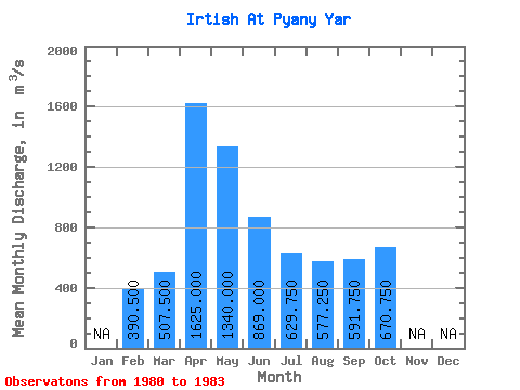
| Statistic | Jan | Feb | Mar | Apr | May | Jun | Jul | Aug | Sep | Oct | Nov | Dec | Annual |
|---|---|---|---|---|---|---|---|---|---|---|---|---|---|
| Mean | 390.50 | 507.50 | 1625.00 | 1340.00 | 869.00 | 629.75 | 577.25 | 591.75 | 670.75 | ||||
| Standard Deviation | 91.22 | 72.83 | 261.63 | 260.13 | 106.35 | 54.20 | 46.10 | 78.61 | 122.77 | ||||
| Min | 326.00 | 456.00 | 1440.00 | 1080.00 | 715.00 | 576.00 | 518.00 | 511.00 | 543.00 | ||||
| Max | 455.00 | 559.00 | 1810.00 | 1700.00 | 958.00 | 688.00 | 619.00 | 686.00 | 830.00 | ||||
| Coefficient of Variation | 0.23 | 0.14 | 0.16 | 0.19 | 0.12 | 0.09 | 0.08 | 0.13 | 0.18 |
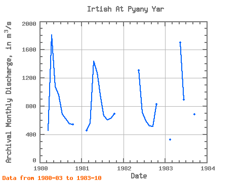
| Year | Jan | Feb | Mar | Apr | May | Jun | Jul | Aug | Sep | Oct | Nov | Dec | Annual | 1980 | 456.00 | 1810.00 | 1080.00 | 958.00 | 688.00 | 619.00 | 546.00 | 543.00 | 1981 | 455.00 | 559.00 | 1440.00 | 1270.00 | 911.00 | 663.00 | 608.00 | 624.00 | 694.00 | 1982 | 1310.00 | 715.00 | 592.00 | 518.00 | 511.00 | 830.00 | 1983 | 326.00 | 1700.00 | 892.00 | 576.00 | 564.00 | 686.00 | 616.00 |
|---|
 Return to R-Arctic Net Home Page