|
|
|||||||||||||||||
| Point ID: 7136 | Downloads | Plots | Site Data | Code: 11663 |
|
|
|||||||||||||||||
| Download | |
|---|---|
| Site Descriptor Information | Site Time Series Data |
| Link to all available data | |
|
|
| View: | Statistics | Time Series |
| Units: | mm |
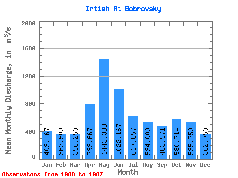
| Statistic | Jan | Feb | Mar | Apr | May | Jun | Jul | Aug | Sep | Oct | Nov | Dec | Annual |
|---|---|---|---|---|---|---|---|---|---|---|---|---|---|
| Mean | 403.17 | 362.50 | 356.25 | 793.67 | 1443.33 | 1022.17 | 617.86 | 534.00 | 483.57 | 580.71 | 535.75 | 362.75 | 599.19 |
| Standard Deviation | 141.12 | 89.03 | 87.85 | 232.32 | 243.79 | 204.80 | 133.77 | 92.72 | 88.23 | 93.18 | 87.64 | 81.70 | 64.17 |
| Min | 277.00 | 238.00 | 241.00 | 597.00 | 1260.00 | 675.00 | 432.00 | 419.00 | 356.00 | 469.00 | 420.00 | 281.00 | 552.33 |
| Max | 676.00 | 511.00 | 454.00 | 1050.00 | 1720.00 | 1210.00 | 798.00 | 646.00 | 573.00 | 688.00 | 633.00 | 466.00 | 672.33 |
| Coefficient of Variation | 0.35 | 0.25 | 0.25 | 0.29 | 0.17 | 0.20 | 0.22 | 0.17 | 0.18 | 0.16 | 0.16 | 0.23 | 0.11 |
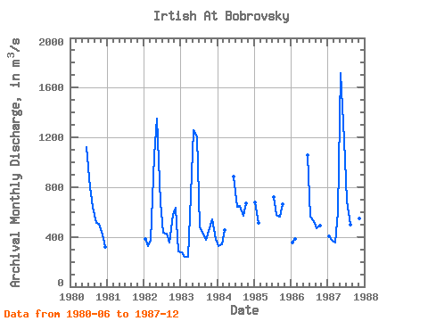
| Year | Jan | Feb | Mar | Apr | May | Jun | Jul | Aug | Sep | Oct | Nov | Dec | Annual | 1980 | 1120.00 | 798.00 | 642.00 | 509.00 | 508.00 | 420.00 | 317.00 | 1982 | 385.00 | 329.00 | 374.00 | 1050.00 | 1350.00 | 675.00 | 432.00 | 430.00 | 356.00 | 580.00 | 633.00 | 281.00 | 572.92 | 1983 | 277.00 | 238.00 | 241.00 | 734.00 | 1260.00 | 1210.00 | 476.00 | 419.00 | 375.00 | 469.00 | 542.00 | 387.00 | 552.33 | 1984 | 324.00 | 341.00 | 454.00 | 888.00 | 639.00 | 646.00 | 573.00 | 669.00 | 1985 | 676.00 | 511.00 | 722.00 | 577.00 | 563.00 | 662.00 | 1986 | 352.00 | 381.00 | 1060.00 | 563.00 | 528.00 | 467.00 | 489.00 | 1987 | 405.00 | 375.00 | 356.00 | 597.00 | 1720.00 | 1180.00 | 695.00 | 496.00 | 542.00 | 688.00 | 548.00 | 466.00 | 672.33 |
|---|
 Return to R-Arctic Net Home Page