|
|
|||||||||||||||||
| Point ID: 7134 | Downloads | Plots | Site Data | Code: 11619 |
|
|
|||||||||||||||||
| Download | |
|---|---|
| Site Descriptor Information | Site Time Series Data |
| Link to all available data | |
|
|
| View: | Statistics | Time Series |
| Units: | mm |
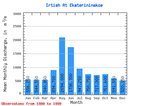
| Statistic | Jan | Feb | Mar | Apr | May | Jun | Jul | Aug | Sep | Oct | Nov | Dec | Annual |
|---|---|---|---|---|---|---|---|---|---|---|---|---|---|
| Mean | 556.25 | 544.55 | 540.85 | 894.70 | 2094.00 | 1736.70 | 947.25 | 750.75 | 717.30 | 751.60 | 591.55 | 520.15 | 887.14 |
| Standard Deviation | 120.30 | 129.92 | 138.80 | 362.25 | 361.60 | 464.55 | 249.15 | 174.68 | 161.12 | 158.34 | 137.76 | 127.64 | 158.77 |
| Min | 351.00 | 342.00 | 288.00 | 484.00 | 1290.00 | 844.00 | 523.00 | 440.00 | 403.00 | 447.00 | 330.00 | 315.00 | 597.83 |
| Max | 776.00 | 802.00 | 821.00 | 1780.00 | 2670.00 | 2430.00 | 1490.00 | 1040.00 | 997.00 | 1040.00 | 933.00 | 811.00 | 1186.17 |
| Coefficient of Variation | 0.22 | 0.24 | 0.26 | 0.41 | 0.17 | 0.27 | 0.26 | 0.23 | 0.23 | 0.21 | 0.23 | 0.24 | 0.18 |
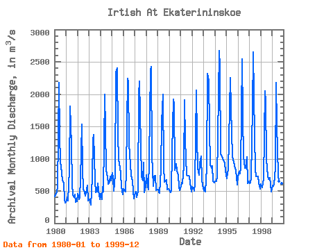
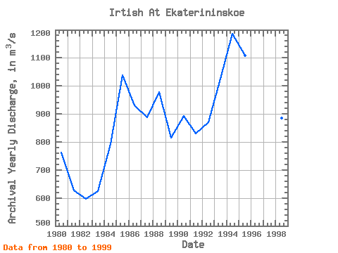
| Year | Jan | Feb | Mar | Apr | May | Jun | Jul | Aug | Sep | Oct | Nov | Dec | Annual | 1980 | 410.00 | 458.00 | 492.00 | 554.00 | 2180.00 | 1360.00 | 967.00 | 777.00 | 656.00 | 621.00 | 370.00 | 315.00 | 763.33 | 1981 | 351.00 | 398.00 | 346.00 | 824.00 | 1810.00 | 1220.00 | 609.00 | 440.00 | 403.00 | 447.00 | 330.00 | 340.00 | 626.50 | 1982 | 453.00 | 376.00 | 400.00 | 689.00 | 1530.00 | 844.00 | 523.00 | 478.00 | 424.00 | 526.00 | 585.00 | 346.00 | 597.83 | 1983 | 374.00 | 342.00 | 288.00 | 705.00 | 1290.00 | 1370.00 | 658.00 | 475.00 | 484.00 | 618.00 | 509.00 | 371.00 | 623.67 | 1984 | 460.00 | 371.00 | 568.00 | 484.00 | 1990.00 | 1470.00 | 820.00 | 717.00 | 609.00 | 641.00 | 729.00 | 659.00 | 793.17 | 1985 | 776.00 | 698.00 | 505.00 | 742.00 | 2340.00 | 2400.00 | 1370.00 | 988.00 | 861.00 | 774.00 | 566.00 | 443.00 | 1038.58 | 1986 | 536.00 | 499.00 | 489.00 | 818.00 | 2240.00 | 2180.00 | 1230.00 | 904.00 | 738.00 | 662.00 | 502.00 | 379.00 | 931.42 | 1987 | 480.00 | 486.00 | 400.00 | 503.00 | 2000.00 | 2200.00 | 1210.00 | 728.00 | 665.00 | 941.00 | 483.00 | 568.00 | 888.67 | 1988 | 743.00 | 564.00 | 520.00 | 992.00 | 2370.00 | 2430.00 | 1050.00 | 578.00 | 725.00 | 740.00 | 514.00 | 521.00 | 978.92 | 1989 | 523.00 | 475.00 | 463.00 | 831.00 | 1580.00 | 2000.00 | 876.00 | 644.00 | 648.00 | 675.00 | 520.00 | 533.00 | 814.00 | 1990 | 510.00 | 481.00 | 505.00 | 1110.00 | 1920.00 | 1830.00 | 826.00 | 914.00 | 813.00 | 745.00 | 555.00 | 513.00 | 893.50 | 1991 | 574.00 | 632.00 | 619.00 | 878.00 | 1910.00 | 1280.00 | 744.00 | 735.00 | 732.00 | 727.00 | 625.00 | 493.00 | 829.08 | 1992 | 564.00 | 551.00 | 498.00 | 615.00 | 2060.00 | 1330.00 | 853.00 | 747.00 | 928.00 | 1040.00 | 671.00 | 586.00 | 870.25 | 1993 | 500.00 | 551.00 | 493.00 | 850.00 | 2320.00 | 2210.00 | 1490.00 | 897.00 | 854.00 | 884.00 | 649.00 | 624.00 | 1026.83 | 1994 | 649.00 | 649.00 | 716.00 | 1330.00 | 2670.00 | 2410.00 | 1070.00 | 1040.00 | 997.00 | 959.00 | 933.00 | 811.00 | 1186.17 | 1995 | 690.00 | 790.00 | 821.00 | 1780.00 | 2250.00 | 1780.00 | 1040.00 | 985.00 | 900.00 | 848.00 | 825.00 | 597.00 | 1108.83 | 1996 | 725.00 | 802.00 | 774.00 | 869.00 | 2540.00 | 1660.00 | 1030.00 | 857.00 | 857.00 | 1030.00 | 613.00 | 650.00 | 1033.92 | 1997 | 622.00 | 630.00 | 702.00 | 1780.00 | 2650.00 | 1350.00 | 839.00 | 724.00 | 723.00 | 725.00 | 625.00 | 537.00 | 992.25 | 1998 | 603.00 | 559.00 | 626.00 | 688.00 | 2050.00 | 1890.00 | 988.00 | 738.00 | 682.00 | 699.00 | 608.00 | 494.00 | 885.42 | 1999 | 582.00 | 579.00 | 592.00 | 852.00 | 2180.00 | 1520.00 | 752.00 | 649.00 | 647.00 | 730.00 | 619.00 | 623.00 | 860.42 |
|---|
 Return to R-Arctic Net Home Page