|
|
|||||||||||||||||
| Point ID: 7128 | Downloads | Plots | Site Data | Code: 11611 |
|
|
|||||||||||||||||
| Download | |
|---|---|
| Site Descriptor Information | Site Time Series Data |
| Link to all available data | |
|
|
| View: | Statistics | Time Series |
| Units: | mm |
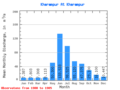
| Statistic | Jan | Feb | Mar | Apr | May | Jun | Jul | Aug | Sep | Oct | Nov | Dec | Annual |
|---|---|---|---|---|---|---|---|---|---|---|---|---|---|
| Mean | 7.39 | 7.80 | 7.31 | 8.11 | 50.30 | 133.53 | 98.53 | 55.12 | 47.38 | 29.10 | 16.10 | 10.45 | 40.39 |
| Standard Deviation | 2.16 | 3.24 | 2.33 | 3.64 | 46.51 | 46.02 | 40.36 | 18.35 | 19.41 | 13.15 | 0.57 | 3.66 | |
| Min | 5.84 | 4.80 | 6.01 | 5.16 | 22.60 | 80.60 | 55.00 | 26.10 | 20.80 | 19.80 | 15.70 | 6.54 | 40.39 |
| Max | 9.85 | 12.30 | 10.80 | 13.10 | 104.00 | 164.00 | 151.00 | 77.00 | 65.70 | 38.40 | 16.50 | 13.80 | 40.39 |
| Coefficient of Variation | 0.29 | 0.41 | 0.32 | 0.45 | 0.93 | 0.34 | 0.41 | 0.33 | 0.41 | 0.45 | 0.04 | 0.35 |
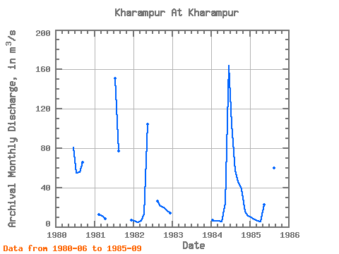
| Year | Jan | Feb | Mar | Apr | May | Jun | Jul | Aug | Sep | Oct | Nov | Dec | Annual | 1980 | 80.60 | 55.00 | 55.70 | 65.70 | 1981 | 12.30 | 10.80 | 8.52 | 151.00 | 77.00 | 6.54 | 1982 | 5.84 | 4.80 | 6.01 | 13.10 | 104.00 | 26.10 | 20.80 | 19.80 | 16.50 | 13.80 | 1984 | 6.47 | 6.31 | 6.11 | 5.16 | 24.30 | 164.00 | 104.00 | 56.90 | 46.30 | 38.40 | 15.70 | 11.00 | 40.39 | 1985 | 9.85 | 7.80 | 6.31 | 5.67 | 22.60 | 156.00 | 84.10 | 59.90 | 56.70 |
|---|
 Return to R-Arctic Net Home Page