|
|
|||||||||||||||||
| Point ID: 7119 | Downloads | Plots | Site Data | Code: 11575 |
|
|
|||||||||||||||||
| Download | |
|---|---|
| Site Descriptor Information | Site Time Series Data |
| Link to all available data | |
| View: | Time Series | All |
| Units: | mm |
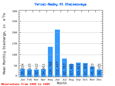
| Statistic | Jan | Feb | Mar | Apr | May | Jun | Jul | Aug | Sep | Oct | Nov | Dec | Annual |
|---|---|---|---|---|---|---|---|---|---|---|---|---|---|
| Mean | 35.83 | 33.62 | 32.41 | 34.66 | 134.77 | 212.41 | 82.76 | 57.48 | 63.62 | 61.38 | 45.82 | 33.02 | 64.03 |
| Standard Deviation | 30.31 | 31.41 | 32.58 | 36.29 | 77.89 | 100.84 | 40.52 | 29.90 | 33.50 | 32.16 | 18.66 | 8.34 | 12.43 |
| Min | 16.20 | 15.50 | 16.80 | 15.80 | 24.60 | 78.10 | 40.20 | 29.90 | 29.70 | 29.60 | 26.10 | 4.67 | 50.11 |
| Max | 199.00 | 206.00 | 212.00 | 226.00 | 285.00 | 429.00 | 189.00 | 179.00 | 178.00 | 180.00 | 122.00 | 48.00 | 101.46 |
| Coefficient of Variation | 0.85 | 0.93 | 1.00 | 1.05 | 0.58 | 0.47 | 0.49 | 0.52 | 0.53 | 0.52 | 0.41 | 0.25 | 0.19 |
 Return to R-Arctic Net Home Page