|
|
|||||||||||||||||
| Point ID: 7119 | Downloads | Plots | Site Data | Code: 11575 |
|
|
|||||||||||||||||
| Download | |
|---|---|
| Site Descriptor Information | Site Time Series Data |
| Link to all available data | |
| View: | Time Series | All |
| Units: | m3/s |
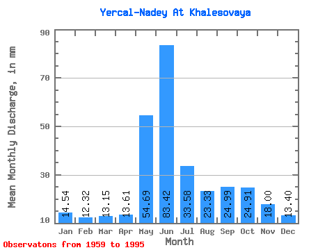
| Statistic | Jan | Feb | Mar | Apr | May | Jun | Jul | Aug | Sep | Oct | Nov | Dec | Annual |
|---|---|---|---|---|---|---|---|---|---|---|---|---|---|
| Mean | 14.54 | 12.43 | 13.15 | 13.61 | 54.68 | 83.42 | 33.58 | 23.32 | 24.99 | 24.91 | 18.00 | 13.40 | 306.16 |
| Standard Deviation | 12.30 | 11.61 | 13.22 | 14.25 | 31.61 | 39.60 | 16.44 | 12.13 | 13.16 | 13.05 | 7.33 | 3.38 | 59.43 |
| Min | 6.57 | 5.73 | 6.82 | 6.21 | 9.98 | 30.67 | 16.31 | 12.13 | 11.66 | 12.01 | 10.25 | 1.90 | 239.61 |
| Max | 80.75 | 76.16 | 86.02 | 88.76 | 115.64 | 168.48 | 76.69 | 72.63 | 69.91 | 73.04 | 47.91 | 19.48 | 485.15 |
| Coefficient of Variation | 0.85 | 0.93 | 1.00 | 1.05 | 0.58 | 0.47 | 0.49 | 0.52 | 0.53 | 0.52 | 0.41 | 0.25 | 0.19 |
 Return to R-Arctic Net Home Page