|
|
|||||||||||||||||
| Point ID: 7119 | Downloads | Plots | Site Data | Code: 11575 |
|
|
|||||||||||||||||
| Download | |
|---|---|
| Site Descriptor Information | Site Time Series Data |
| Link to all available data | |
|
|
| View: | Statistics | Time Series |
| Units: | mm |
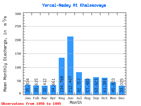
| Statistic | Jan | Feb | Mar | Apr | May | Jun | Jul | Aug | Sep | Oct | Nov | Dec | Annual |
|---|---|---|---|---|---|---|---|---|---|---|---|---|---|
| Mean | 35.83 | 33.62 | 32.41 | 34.66 | 134.77 | 212.41 | 82.76 | 57.48 | 63.62 | 61.38 | 45.82 | 33.02 | 64.03 |
| Standard Deviation | 30.31 | 31.41 | 32.58 | 36.29 | 77.89 | 100.84 | 40.52 | 29.90 | 33.50 | 32.16 | 18.66 | 8.34 | 12.43 |
| Min | 16.20 | 15.50 | 16.80 | 15.80 | 24.60 | 78.10 | 40.20 | 29.90 | 29.70 | 29.60 | 26.10 | 4.67 | 50.11 |
| Max | 199.00 | 206.00 | 212.00 | 226.00 | 285.00 | 429.00 | 189.00 | 179.00 | 178.00 | 180.00 | 122.00 | 48.00 | 101.46 |
| Coefficient of Variation | 0.85 | 0.93 | 1.00 | 1.05 | 0.58 | 0.47 | 0.49 | 0.52 | 0.53 | 0.52 | 0.41 | 0.25 | 0.19 |
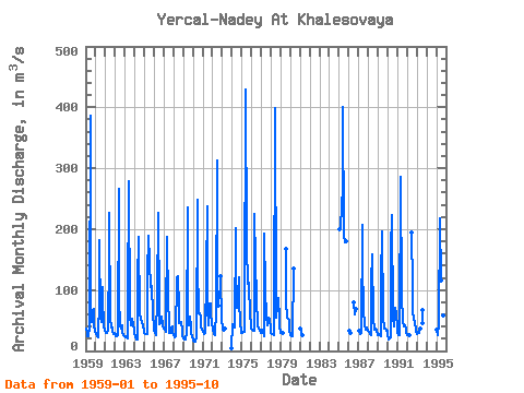
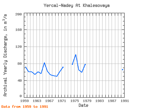
| Year | Jan | Feb | Mar | Apr | May | Jun | Jul | Aug | Sep | Oct | Nov | Dec | Annual | 1959 | 37.00 | 29.40 | 24.80 | 23.70 | 39.10 | 387.00 | 67.60 | 47.40 | 67.80 | 68.90 | 43.30 | 31.40 | 72.28 | 1960 | 28.40 | 24.50 | 23.90 | 22.00 | 83.60 | 182.00 | 53.80 | 47.70 | 104.00 | 85.30 | 42.00 | 32.40 | 60.80 | 1961 | 31.90 | 29.70 | 29.00 | 33.60 | 158.00 | 226.00 | 52.00 | 39.10 | 39.20 | 32.30 | 27.60 | 28.80 | 60.60 | 1962 | 27.20 | 24.40 | 23.50 | 25.30 | 267.00 | 86.20 | 40.20 | 37.30 | 41.60 | 29.60 | 26.10 | 24.50 | 54.41 | 1963 | 23.40 | 21.80 | 21.60 | 21.20 | 74.10 | 278.00 | 58.80 | 41.40 | 50.70 | 53.60 | 44.40 | 34.00 | 60.25 | 1964 | 28.10 | 23.30 | 19.70 | 19.50 | 114.00 | 187.00 | 59.50 | 54.30 | 51.00 | 48.40 | 40.30 | 33.80 | 56.58 | 1965 | 30.20 | 28.20 | 27.20 | 27.50 | 124.00 | 189.00 | 146.00 | 104.00 | 105.00 | 106.00 | 62.20 | 38.50 | 82.32 | 1966 | 32.60 | 30.90 | 26.80 | 27.80 | 86.60 | 226.00 | 71.10 | 44.10 | 44.90 | 57.00 | 44.00 | 39.60 | 60.95 | 1967 | 37.60 | 35.30 | 31.50 | 52.50 | 188.00 | 78.10 | 51.40 | 29.90 | 29.70 | 36.50 | 39.50 | 29.30 | 53.27 | 1968 | 25.80 | 22.70 | 23.40 | 26.60 | 121.00 | 123.00 | 70.90 | 45.20 | 45.10 | 47.40 | 35.10 | 25.50 | 50.98 | 1969 | 20.00 | 20.60 | 19.70 | 19.40 | 28.90 | 236.00 | 66.30 | 42.10 | 56.20 | 38.20 | 27.70 | 26.20 | 50.11 | 1970 | 16.20 | 15.50 | 16.80 | 15.80 | 24.60 | 249.00 | 142.00 | 62.30 | 61.80 | 55.00 | 41.00 | 34.40 | 61.20 | 1971 | 31.60 | 30.10 | 27.80 | 29.60 | 125.00 | 237.00 | 70.00 | 41.40 | 77.20 | 78.80 | 60.80 | 45.70 | 71.25 | 1972 | 35.50 | 29.90 | 27.00 | 25.90 | 64.80 | 312.00 | 121.00 | 74.50 | 122.00 | 48.00 | 1973 | 40.20 | 35.40 | 32.40 | 36.80 | 4.67 | 1974 | 44.40 | 39.90 | 41.00 | 39.30 | 201.00 | 144.00 | 71.00 | 82.20 | 121.00 | 79.10 | 47.00 | 29.90 | 78.32 | 1975 | 29.70 | 31.20 | 30.60 | 31.30 | 56.90 | 429.00 | 171.00 | 110.00 | 116.00 | 108.00 | 58.80 | 45.00 | 101.46 | 1976 | 36.50 | 35.80 | 32.30 | 32.50 | 225.00 | 148.00 | 84.20 | 43.80 | 40.70 | 36.20 | 33.60 | 29.00 | 64.80 | 1977 | 32.00 | 34.70 | 32.90 | 24.40 | 193.00 | 98.70 | 56.30 | 43.00 | 48.80 | 54.20 | 51.00 | 37.90 | 58.91 | 1978 | 30.40 | 27.20 | 27.00 | 25.40 | 43.90 | 399.00 | 75.10 | 54.00 | 74.00 | 86.40 | 53.50 | 40.00 | 77.99 | 1979 | 30.40 | 28.80 | 28.60 | 28.70 | 168.00 | 79.00 | 54.40 | 53.00 | 50.10 | 33.90 | 1980 | 26.20 | 23.30 | 24.70 | 26.00 | 136.00 | 1981 | 36.40 | 30.00 | 25.30 | 1985 | 199.00 | 206.00 | 212.00 | 226.00 | 276.00 | 401.00 | 189.00 | 179.00 | 178.00 | 180.00 | 1986 | 32.60 | 31.70 | 28.70 | 79.10 | 59.20 | 69.00 | 1987 | 33.10 | 28.20 | 29.80 | 207.00 | 145.00 | 65.00 | 43.10 | 35.20 | 38.60 | 38.90 | 32.80 | 1988 | 30.70 | 30.80 | 26.90 | 26.30 | 113.00 | 158.00 | 51.20 | 37.90 | 35.40 | 37.10 | 33.90 | 28.50 | 50.81 | 1989 | 26.40 | 27.70 | 26.00 | 24.10 | 117.00 | 196.00 | 56.20 | 37.40 | 37.00 | 36.60 | 33.80 | 33.50 | 54.31 | 1990 | 26.00 | 18.10 | 20.10 | 22.50 | 167.00 | 224.00 | 55.80 | 40.30 | 43.90 | 71.20 | 60.50 | 40.60 | 65.83 | 1991 | 30.40 | 25.40 | 26.40 | 30.50 | 285.00 | 86.00 | 53.80 | 48.40 | 39.90 | 41.60 | 36.70 | 29.90 | 61.17 | 1992 | 26.50 | 25.60 | 24.80 | 25.30 | 195.00 | 106.00 | 63.10 | 55.40 | 46.00 | 37.60 | 33.90 | 1993 | 28.60 | 32.10 | 32.90 | 29.80 | 37.00 | 66.90 | 45.40 | 1995 | 34.80 | 26.20 | 26.10 | 45.40 | 217.00 | 115.00 | 63.50 | 48.00 | 58.50 | 52.30 |
|---|
 Return to R-Arctic Net Home Page