|
|
|||||||||||||||||
| Point ID: 7106 | Downloads | Plots | Site Data | Code: 11548 |
|
|
|||||||||||||||||
| Download | |
|---|---|
| Site Descriptor Information | Site Time Series Data |
| Link to all available data | |
|
|
| View: | Statistics | Time Series |
| Units: | mm |
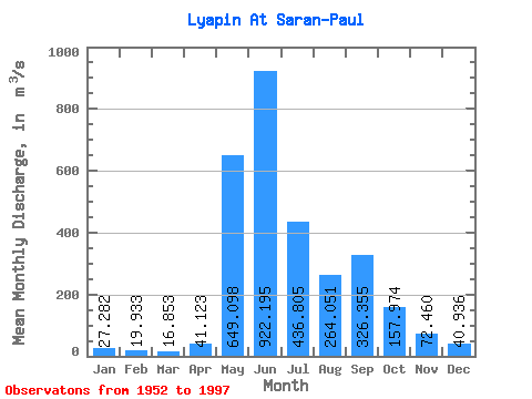
| Statistic | Jan | Feb | Mar | Apr | May | Jun | Jul | Aug | Sep | Oct | Nov | Dec | Annual |
|---|---|---|---|---|---|---|---|---|---|---|---|---|---|
| Mean | 27.28 | 19.93 | 16.85 | 41.12 | 649.10 | 922.20 | 436.81 | 264.05 | 326.36 | 157.97 | 72.46 | 40.94 | 247.96 |
| Standard Deviation | 6.21 | 5.08 | 4.11 | 63.29 | 325.60 | 392.16 | 213.98 | 147.46 | 170.79 | 56.73 | 21.50 | 9.06 | 46.35 |
| Min | 16.70 | 11.40 | 8.65 | 7.36 | 103.00 | 332.00 | 106.00 | 90.40 | 80.90 | 62.30 | 32.20 | 27.00 | 150.80 |
| Max | 43.80 | 31.70 | 26.90 | 390.00 | 1290.00 | 1830.00 | 1020.00 | 778.00 | 782.00 | 324.00 | 136.00 | 62.50 | 345.47 |
| Coefficient of Variation | 0.23 | 0.26 | 0.24 | 1.54 | 0.50 | 0.42 | 0.49 | 0.56 | 0.52 | 0.36 | 0.30 | 0.22 | 0.19 |
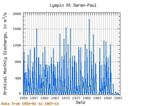
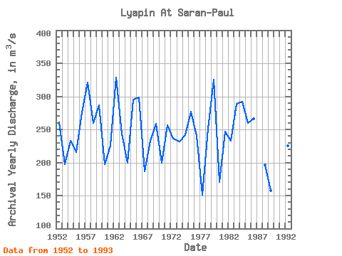
| Year | Jan | Feb | Mar | Apr | May | Jun | Jul | Aug | Sep | Oct | Nov | Dec | Annual | 1952 | 31.60 | 22.80 | 14.90 | 14.10 | 643.00 | 1040.00 | 252.00 | 304.00 | 527.00 | 193.00 | 52.90 | 27.30 | 260.22 | 1953 | 16.70 | 15.20 | 14.40 | 390.00 | 550.00 | 541.00 | 196.00 | 91.70 | 327.00 | 138.00 | 53.00 | 33.50 | 197.21 | 1954 | 23.00 | 19.10 | 18.50 | 89.20 | 518.00 | 962.00 | 292.00 | 227.00 | 314.00 | 209.00 | 80.70 | 42.90 | 232.95 | 1955 | 30.80 | 23.80 | 17.40 | 81.10 | 1090.00 | 504.00 | 260.00 | 187.00 | 181.00 | 112.00 | 56.90 | 39.60 | 215.30 | 1956 | 24.10 | 13.80 | 12.10 | 13.50 | 565.00 | 439.00 | 561.00 | 778.00 | 531.00 | 241.00 | 87.00 | 46.90 | 276.03 | 1957 | 34.60 | 24.60 | 18.90 | 20.30 | 1080.00 | 1150.00 | 927.00 | 143.00 | 176.00 | 152.00 | 76.10 | 47.10 | 320.80 | 1958 | 32.80 | 26.20 | 20.00 | 19.90 | 194.00 | 1600.00 | 439.00 | 295.00 | 222.00 | 141.00 | 85.60 | 43.80 | 259.94 | 1959 | 26.50 | 23.30 | 20.10 | 15.50 | 906.00 | 890.00 | 596.00 | 168.00 | 480.00 | 183.00 | 82.60 | 42.20 | 286.10 | 1960 | 26.30 | 16.60 | 12.40 | 75.40 | 432.00 | 737.00 | 216.00 | 172.00 | 385.00 | 205.00 | 55.30 | 32.30 | 197.11 | 1961 | 24.70 | 18.00 | 17.30 | 17.20 | 533.00 | 1020.00 | 298.00 | 204.00 | 314.00 | 156.00 | 62.70 | 39.50 | 225.37 | 1962 | 28.10 | 23.60 | 18.80 | 53.20 | 1160.00 | 643.00 | 450.00 | 450.00 | 727.00 | 226.00 | 104.00 | 52.40 | 328.01 | 1963 | 30.40 | 24.40 | 17.60 | 16.40 | 725.00 | 590.00 | 316.00 | 565.00 | 287.00 | 229.00 | 80.30 | 44.70 | 243.82 | 1964 | 26.40 | 18.00 | 14.20 | 13.50 | 706.00 | 665.00 | 247.00 | 167.00 | 258.00 | 191.00 | 53.90 | 36.60 | 199.72 | 1965 | 28.30 | 18.80 | 17.30 | 20.00 | 600.00 | 908.00 | 573.00 | 634.00 | 441.00 | 175.00 | 86.80 | 45.70 | 295.66 | 1966 | 28.90 | 19.10 | 13.80 | 15.10 | 1120.00 | 738.00 | 322.00 | 224.00 | 730.00 | 242.00 | 84.10 | 41.80 | 298.23 | 1967 | 25.20 | 18.70 | 21.40 | 143.00 | 681.00 | 468.00 | 307.00 | 123.00 | 111.00 | 145.00 | 136.00 | 62.50 | 186.82 | 1968 | 35.10 | 26.20 | 21.60 | 22.00 | 706.00 | 792.00 | 442.00 | 330.00 | 211.00 | 120.00 | 59.50 | 30.20 | 232.97 | 1969 | 23.30 | 14.60 | 11.90 | 11.50 | 103.00 | 1470.00 | 569.00 | 329.00 | 348.00 | 129.00 | 65.90 | 33.80 | 259.08 | 1970 | 19.00 | 13.20 | 12.80 | 13.80 | 345.00 | 930.00 | 450.00 | 227.00 | 175.00 | 111.00 | 70.40 | 32.10 | 199.94 | 1971 | 17.70 | 11.70 | 8.65 | 7.36 | 358.00 | 1360.00 | 547.00 | 200.00 | 367.00 | 104.00 | 63.00 | 36.00 | 256.70 | 1972 | 23.10 | 17.40 | 16.10 | 17.00 | 147.00 | 1630.00 | 400.00 | 201.00 | 212.00 | 99.90 | 44.80 | 27.00 | 236.28 | 1973 | 16.70 | 11.40 | 9.03 | 43.40 | 1220.00 | 634.00 | 260.00 | 217.00 | 178.00 | 95.20 | 59.20 | 36.60 | 231.71 | 1974 | 29.40 | 19.80 | 17.90 | 18.40 | 162.00 | 1610.00 | 507.00 | 173.00 | 168.00 | 110.00 | 52.50 | 29.60 | 241.47 | 1975 | 22.20 | 14.70 | 14.50 | 20.00 | 527.00 | 827.00 | 933.00 | 403.00 | 305.00 | 155.00 | 62.60 | 44.70 | 277.39 | 1976 | 30.90 | 24.20 | 21.70 | 24.00 | 662.00 | 946.00 | 705.00 | 161.00 | 180.00 | 62.30 | 32.20 | 29.40 | 239.89 | 1977 | 17.20 | 11.60 | 10.80 | 44.70 | 770.00 | 332.00 | 106.00 | 138.00 | 202.00 | 84.60 | 57.30 | 35.40 | 150.80 | 1978 | 20.90 | 16.00 | 13.50 | 15.30 | 107.00 | 1150.00 | 1020.00 | 224.00 | 213.00 | 121.00 | 71.40 | 41.10 | 251.10 | 1979 | 29.30 | 19.90 | 14.10 | 18.60 | 1140.00 | 875.00 | 647.00 | 366.00 | 494.00 | 186.00 | 72.40 | 38.20 | 325.04 | 1980 | 21.80 | 13.50 | 12.20 | 41.90 | 443.00 | 362.00 | 299.00 | 166.00 | 317.00 | 252.00 | 68.00 | 49.40 | 170.48 | 1981 | 36.10 | 29.80 | 24.20 | 21.60 | 373.00 | 1220.00 | 305.00 | 384.00 | 250.00 | 170.00 | 89.00 | 56.40 | 246.59 | 1982 | 37.20 | 27.10 | 21.30 | 39.70 | 1100.00 | 724.00 | 299.00 | 186.00 | 201.00 | 63.70 | 54.80 | 38.40 | 232.68 | 1983 | 29.20 | 21.40 | 16.80 | 25.30 | 383.00 | 1830.00 | 311.00 | 204.00 | 236.00 | 207.00 | 135.00 | 61.60 | 288.36 | 1984 | 42.90 | 31.70 | 26.90 | 21.80 | 724.00 | 1050.00 | 402.00 | 367.00 | 611.00 | 129.00 | 66.50 | 35.90 | 292.39 | 1985 | 21.80 | 15.50 | 11.60 | 13.50 | 214.00 | 1460.00 | 499.00 | 419.00 | 233.00 | 112.00 | 69.50 | 43.70 | 259.38 | 1986 | 28.20 | 23.40 | 21.40 | 26.40 | 759.00 | 643.00 | 727.00 | 293.00 | 412.00 | 153.00 | 70.40 | 37.70 | 266.21 | 1988 | 27.00 | 16.30 | 14.60 | 20.10 | 460.00 | 1130.00 | 253.00 | 90.40 | 80.90 | 145.00 | 70.10 | 41.70 | 195.76 | 1989 | 27.20 | 20.60 | 20.80 | 19.70 | 718.00 | 424.00 | 176.00 | 111.00 | 206.00 | 89.20 | 49.90 | 30.20 | 157.72 | 1990 | 22.00 | 19.10 | 16.50 | 34.60 | 811.00 | 1310.00 | 200.00 | 117.00 | 314.00 | 132.00 | 69.00 | 39.30 | 257.04 | 1991 | 25.20 | 17.00 | 17.50 | 144.00 | 1290.00 | 544.00 | 618.00 | 203.00 | 782.00 | 324.00 | 122.00 | 58.90 | 345.47 | 1992 | 33.20 | 26.80 | 23.00 | 22.30 | 893.00 | 442.00 | 526.00 | 268.00 | 231.00 | 120.00 | 73.90 | 44.00 | 225.27 | 1993 | 27.90 | 25.20 | 20.80 | 20.40 | 695.00 | 1220.00 | 456.00 | 316.00 | 527.00 | 217.00 | 77.70 | 37.60 | 303.38 | 1994 | 27.10 | 17.50 | 14.00 | 22.40 | 242.00 | 205.00 | 78.40 | 50.00 | 1995 | 30.90 | 22.60 | 18.80 | 58.30 | 1996 | 43.80 | 26.70 | 20.20 | 34.00 | 1997 | 23.00 | 16.10 | 16.10 | 32.10 |
|---|
 Return to R-Arctic Net Home Page