|
|
|||||||||||||||||
| Point ID: 7077 | Downloads | Plots | Site Data | Code: 11487 |
|
|
|||||||||||||||||
| Download | |
|---|---|
| Site Descriptor Information | Site Time Series Data |
| Link to all available data | |
| View: | Time Series | All |
| Units: | m3/s |
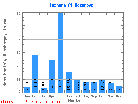
| Statistic | Jan | Feb | Mar | Apr | May | Jun | Jul | Aug | Sep | Oct | Nov | Dec | Annual |
|---|---|---|---|---|---|---|---|---|---|---|---|---|---|
| Mean | 4.31 | 28.34 | 3.92 | 24.68 | 59.90 | 15.27 | 9.85 | 8.33 | 7.91 | 10.74 | 7.16 | 4.88 | 186.87 |
| Standard Deviation | 0.85 | 118.98 | 0.61 | 16.15 | 36.85 | 16.10 | 9.01 | 9.29 | 4.75 | 7.88 | 4.29 | 1.38 | 162.80 |
| Min | 2.92 | 2.34 | 2.92 | 3.67 | 11.84 | 4.97 | 3.15 | 3.50 | 3.78 | 3.38 | 3.39 | 3.03 | 98.32 |
| Max | 5.78 | 574.12 | 5.08 | 55.96 | 147.03 | 83.58 | 43.29 | 48.54 | 19.88 | 31.86 | 22.19 | 8.87 | 851.51 |
| Coefficient of Variation | 0.20 | 4.20 | 0.16 | 0.66 | 0.61 | 1.05 | 0.91 | 1.11 | 0.60 | 0.73 | 0.60 | 0.28 | 0.87 |
 Return to R-Arctic Net Home Page