|
|
|||||||||||||||||
| Point ID: 7066 | Downloads | Plots | Site Data | Code: 11441 |
|
|
|||||||||||||||||
| Download | |
|---|---|
| Site Descriptor Information | Site Time Series Data |
| Link to all available data | |
| View: | Time Series | All |
| Units: | m3/s |
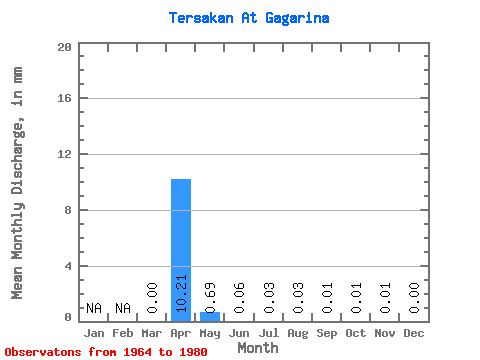
| Statistic | Jan | Feb | Mar | Apr | May | Jun | Jul | Aug | Sep | Oct | Nov | Dec | Annual |
|---|---|---|---|---|---|---|---|---|---|---|---|---|---|
| Mean | 0.00 | 10.21 | 0.69 | 0.06 | 0.03 | 0.03 | 0.01 | 0.01 | 0.01 | 0.00 | |||
| Standard Deviation | 0.00 | 5.86 | 0.77 | 0.04 | 0.03 | 0.02 | 0.01 | ||||||
| Min | 0.00 | 1.46 | 0.03 | 0.00 | 0.00 | 0.00 | 0.00 | 0.01 | 0.01 | 0.00 | |||
| Max | 0.01 | 18.47 | 2.70 | 0.12 | 0.06 | 0.05 | 0.01 | 0.01 | 0.01 | 0.00 | |||
| Coefficient of Variation | 0.51 | 0.57 | 1.12 | 0.70 | 1.05 | 0.90 | 0.85 |
 Return to R-Arctic Net Home Page