|
|
|||||||||||||||||
| Point ID: 7035 | Downloads | Plots | Site Data | Code: 11368 |
|
|
|||||||||||||||||
| Download | |
|---|---|
| Site Descriptor Information | Site Time Series Data |
| Link to all available data | |
| View: | Time Series | All |
| Units: | m3/s |
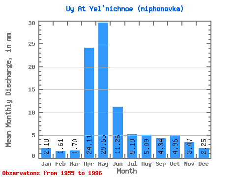
| Statistic | Jan | Feb | Mar | Apr | May | Jun | Jul | Aug | Sep | Oct | Nov | Dec | Annual |
|---|---|---|---|---|---|---|---|---|---|---|---|---|---|
| Mean | 2.18 | 1.62 | 1.70 | 24.11 | 29.65 | 11.26 | 5.18 | 5.09 | 4.34 | 4.96 | 3.47 | 2.25 | 97.71 |
| Standard Deviation | 1.94 | 0.47 | 0.43 | 27.11 | 17.96 | 8.02 | 4.17 | 4.85 | 3.73 | 4.44 | 3.09 | 1.08 | 57.50 |
| Min | 0.96 | 0.95 | 0.96 | 2.16 | 2.11 | 1.80 | 1.19 | 1.31 | 1.33 | 1.00 | 0.79 | 1.04 | 21.26 |
| Max | 13.08 | 2.83 | 2.92 | 162.84 | 65.62 | 34.63 | 20.65 | 24.94 | 18.92 | 22.08 | 18.62 | 6.07 | 285.57 |
| Coefficient of Variation | 0.89 | 0.29 | 0.25 | 1.12 | 0.61 | 0.71 | 0.80 | 0.95 | 0.86 | 0.90 | 0.89 | 0.48 | 0.59 |
 Return to R-Arctic Net Home Page