|
|
|||||||||||||||||
| Point ID: 703 | Downloads | Plots | Site Data | Other Close Sites | Code: 07DA001 |
|
|
|||||||||||||||||
| Download | |
|---|---|
| Site Descriptor Information | Site Time Series Data |
| Link to all available data | |
|
|
| View: | Statistics | Time Series |
| Units: | mm |
| Statistic | Jan | Feb | Mar | Apr | May | Jun | Jul | Aug | Sep | Oct | Nov | Dec | Annual |
|---|---|---|---|---|---|---|---|---|---|---|---|---|---|
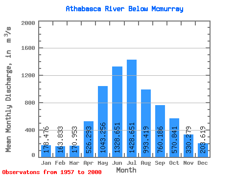
| Mean | 178.48 | 163.83 | 170.95 | 526.29 | 1043.26 | 1328.65 | 1428.65 | 993.42 | 760.19 | 570.84 | 330.28 | 203.62 | 647.35 |
| Standard Deviation | 43.28 | 36.56 | 37.86 | 209.65 | 375.57 | 389.77 | 430.39 | 261.13 | 243.78 | 178.38 | 95.29 | 54.76 | 134.48 |
| Min | 101.00 | 105.00 | 107.00 | 213.00 | 485.00 | 671.00 | 731.00 | 557.00 | 412.00 | 273.00 | 155.00 | 107.00 | 447.67 |
| Max | 261.00 | 266.00 | 271.00 | 1030.00 | 2080.00 | 2210.00 | 2740.00 | 1740.00 | 1510.00 | 1040.00 | 635.00 | 353.00 | 1008.33 |
| Coefficient of Variation | 0.24 | 0.22 | 0.22 | 0.40 | 0.36 | 0.29 | 0.30 | 0.26 | 0.32 | 0.31 | 0.29 | 0.27 | 0.21 |
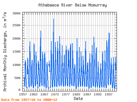
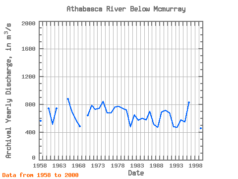
| Year | Jan | Feb | Mar | Apr | May | Jun | Jul | Aug | Sep | Oct | Nov | Dec | Annual | 1957 | 532.00 | 438.00 | 287.00 | 1958 | 215.00 | 179.00 | 182.00 | 1030.00 | 1170.00 | 1070.00 | 1090.00 | 578.00 | 489.00 | 400.00 | 233.00 | 151.00 | 565.58 | 1959 | 124.00 | 111.00 | 124.00 | 665.00 | 1250.00 | 1130.00 | 653.00 | 818.00 | 622.00 | 297.00 | 236.00 | 1960 | 172.00 | 156.00 | 146.00 | 475.00 | 1060.00 | 1530.00 | 1880.00 | 1060.00 | 1110.00 | 655.00 | 439.00 | 224.00 | 742.25 | 1961 | 209.00 | 180.00 | 184.00 | 366.00 | 850.00 | 1120.00 | 1180.00 | 783.00 | 435.00 | 400.00 | 266.00 | 152.00 | 510.42 | 1962 | 142.00 | 122.00 | 121.00 | 521.00 | 1630.00 | 1800.00 | 1690.00 | 1050.00 | 740.00 | 509.00 | 370.00 | 244.00 | 744.92 | 1963 | 200.00 | 192.00 | 189.00 | 808.00 | 1480.00 | 1190.00 | 913.00 | 692.00 | 588.00 | 457.00 | 289.00 | 1964 | 125.00 | 213.00 | 956.00 | 1140.00 | 1050.00 | 995.00 | 835.00 | 864.00 | 361.00 | 175.00 | 1965 | 207.00 | 174.00 | 182.00 | 414.00 | 1620.00 | 1760.00 | 2290.00 | 1160.00 | 1200.00 | 854.00 | 421.00 | 271.00 | 879.42 | 1966 | 214.00 | 208.00 | 206.00 | 389.00 | 1170.00 | 1480.00 | 1290.00 | 1190.00 | 1030.00 | 572.00 | 349.00 | 247.00 | 695.42 | 1967 | 216.00 | 188.00 | 156.00 | 320.00 | 1350.00 | 1460.00 | 1080.00 | 859.00 | 531.00 | 371.00 | 245.00 | 135.00 | 575.92 | 1968 | 116.00 | 121.00 | 161.00 | 285.00 | 551.00 | 965.00 | 1090.00 | 882.00 | 654.00 | 513.00 | 308.00 | 161.00 | 483.92 | 1969 | 147.00 | 122.00 | 118.00 | 1020.00 | 993.00 | 920.00 | 1150.00 | 836.00 | 743.00 | 1970 | 148.00 | 151.00 | 152.00 | 590.00 | 909.00 | 1210.00 | 1890.00 | 919.00 | 712.00 | 565.00 | 284.00 | 178.00 | 642.33 | 1971 | 154.00 | 145.00 | 144.00 | 690.00 | 1070.00 | 1750.00 | 2740.00 | 1100.00 | 647.00 | 553.00 | 286.00 | 178.00 | 788.08 | 1972 | 195.00 | 172.00 | 195.00 | 528.00 | 1710.00 | 1860.00 | 1470.00 | 914.00 | 603.00 | 588.00 | 332.00 | 185.00 | 729.33 | 1973 | 191.00 | 171.00 | 171.00 | 445.00 | 1120.00 | 1890.00 | 1340.00 | 1220.00 | 785.00 | 790.00 | 447.00 | 293.00 | 738.58 | 1974 | 239.00 | 213.00 | 189.00 | 937.00 | 2080.00 | 1520.00 | 1790.00 | 1060.00 | 824.00 | 641.00 | 337.00 | 268.00 | 841.50 | 1975 | 213.00 | 188.00 | 204.00 | 383.00 | 985.00 | 976.00 | 1730.00 | 1020.00 | 1070.00 | 673.00 | 449.00 | 254.00 | 678.75 | 1976 | 224.00 | 194.00 | 180.00 | 851.00 | 706.00 | 825.00 | 1310.00 | 1380.00 | 1230.00 | 705.00 | 331.00 | 194.00 | 677.50 | 1977 | 209.00 | 208.00 | 224.00 | 750.00 | 1380.00 | 1710.00 | 1390.00 | 1090.00 | 918.00 | 731.00 | 347.00 | 221.00 | 764.83 | 1978 | 225.00 | 190.00 | 198.00 | 555.00 | 1120.00 | 1590.00 | 1340.00 | 935.00 | 1510.00 | 859.00 | 450.00 | 277.00 | 770.75 | 1979 | 214.00 | 168.00 | 173.00 | 393.00 | 1560.00 | 1720.00 | 1790.00 | 954.00 | 804.00 | 581.00 | 360.00 | 225.00 | 745.17 | 1980 | 242.00 | 205.00 | 206.00 | 614.00 | 688.00 | 1810.00 | 1260.00 | 1210.00 | 990.00 | 727.00 | 463.00 | 196.00 | 717.58 | 1981 | 196.00 | 190.00 | 220.00 | 505.00 | 734.00 | 1010.00 | 883.00 | 815.00 | 482.00 | 342.00 | 277.00 | 107.00 | 480.08 | 1982 | 109.00 | 109.00 | 107.00 | 292.00 | 1150.00 | 981.00 | 1990.00 | 1050.00 | 790.00 | 609.00 | 340.00 | 233.00 | 646.67 | 1983 | 170.00 | 157.00 | 162.00 | 418.00 | 545.00 | 883.00 | 1660.00 | 1080.00 | 616.00 | 484.00 | 490.00 | 212.00 | 573.08 | 1984 | 178.00 | 187.00 | 189.00 | 471.00 | 691.00 | 1490.00 | 1120.00 | 722.00 | 812.00 | 723.00 | 365.00 | 233.00 | 598.42 | 1985 | 192.00 | 173.00 | 175.00 | 584.00 | 1330.00 | 1020.00 | 936.00 | 656.00 | 724.00 | 616.00 | 357.00 | 202.00 | 580.42 | 1986 | 174.00 | 167.00 | 205.00 | 554.00 | 1020.00 | 1310.00 | 1890.00 | 1130.00 | 652.00 | 737.00 | 374.00 | 203.00 | 701.33 | 1987 | 172.00 | 168.00 | 175.00 | 682.00 | 852.00 | 1070.00 | 749.00 | 1080.00 | 555.00 | 329.00 | 211.00 | 148.00 | 515.92 | 1988 | 101.00 | 105.00 | 132.00 | 306.00 | 487.00 | 1010.00 | 1420.00 | 744.00 | 544.00 | 388.00 | 231.00 | 169.00 | 469.75 | 1989 | 136.00 | 130.00 | 135.00 | 225.00 | 909.00 | 1190.00 | 1620.00 | 1740.00 | 978.00 | 626.00 | 384.00 | 228.00 | 691.75 | 1990 | 220.00 | 174.00 | 212.00 | 666.00 | 1250.00 | 2050.00 | 1630.00 | 796.00 | 623.00 | 470.00 | 284.00 | 205.00 | 715.00 | 1991 | 150.00 | 156.00 | 150.00 | 483.00 | 1300.00 | 1590.00 | 1650.00 | 1130.00 | 697.00 | 412.00 | 238.00 | 158.00 | 676.17 | 1992 | 151.00 | 146.00 | 271.00 | 521.00 | 890.00 | 1110.00 | 731.00 | 557.00 | 509.00 | 380.00 | 262.00 | 152.00 | 473.33 | 1993 | 123.00 | 120.00 | 136.00 | 320.00 | 674.00 | 671.00 | 1050.00 | 961.00 | 677.00 | 441.00 | 238.00 | 186.00 | 466.42 | 1994 | 157.00 | 146.00 | 167.00 | 592.00 | 959.00 | 1350.00 | 1490.00 | 812.00 | 457.00 | 392.00 | 211.00 | 174.00 | 575.58 | 1995 | 161.00 | 143.00 | 137.00 | 299.00 | 531.00 | 1100.00 | 1200.00 | 1530.00 | 645.00 | 393.00 | 235.00 | 183.00 | 546.42 | 1996 | 152.00 | 121.00 | 138.00 | 743.00 | 997.00 | 1920.00 | 1770.00 | 1580.00 | 1010.00 | 834.00 | 375.00 | 285.00 | 827.08 | 1997 | 261.00 | 233.00 | 228.00 | 1030.00 | 1670.00 | 2210.00 | 2170.00 | 1220.00 | 1050.00 | 1040.00 | 635.00 | 353.00 | 1008.33 | 1998 | 259.00 | 266.00 | 240.00 | 615.00 | 728.00 | 843.00 | 1250.00 | 730.00 | 412.00 | 347.00 | 241.00 | 132.00 | 505.25 | 1999 | 114.00 | 119.00 | 131.00 | 489.00 | 808.00 | 800.00 | 1280.00 | 710.00 | 478.00 | 273.00 | 155.00 | 110.00 | 455.58 | 2000 | 104.00 | 113.00 | 111.00 | 226.00 | 485.00 | 905.00 | 1290.00 | 820.00 | 618.00 | 376.00 | 197.00 | 127.00 | 447.67 |
|---|
| Other Close Sites | ||||||
|---|---|---|---|---|---|---|
| PointID | Latitude | Longitude | Drainage Area | Source | Name | |
| 695 | "CLEARWATER RIVER AT DRAPER" | 56.68 | 1324043 | Hydat | ||
 Return to R-Arctic Net Home Page