|
|
|||||||||||||||||
| Point ID: 7021 | Downloads | Plots | Site Data | Code: 11336 |
|
|
|||||||||||||||||
| Download | |
|---|---|
| Site Descriptor Information | Site Time Series Data |
| Link to all available data | |
| View: | Time Series | All |
| Units: | mm |
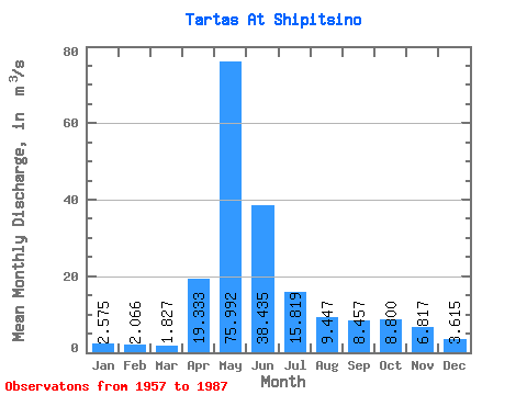
| Statistic | Jan | Feb | Mar | Apr | May | Jun | Jul | Aug | Sep | Oct | Nov | Dec | Annual |
|---|---|---|---|---|---|---|---|---|---|---|---|---|---|
| Mean | 2.58 | 2.07 | 1.83 | 19.33 | 75.99 | 38.44 | 15.82 | 9.45 | 8.46 | 8.80 | 6.82 | 3.62 | 16.10 |
| Standard Deviation | 1.57 | 0.97 | 0.59 | 19.00 | 47.88 | 41.36 | 22.22 | 13.33 | 12.82 | 10.13 | 6.08 | 2.63 | 11.94 |
| Min | 1.00 | 0.97 | 1.05 | 2.62 | 3.94 | 1.76 | 1.21 | 1.15 | 1.67 | 1.70 | 1.54 | 1.15 | 1.82 |
| Max | 8.03 | 5.53 | 3.89 | 80.20 | 171.00 | 152.00 | 95.00 | 69.20 | 70.50 | 36.10 | 23.80 | 12.40 | 53.70 |
| Coefficient of Variation | 0.61 | 0.47 | 0.32 | 0.98 | 0.63 | 1.08 | 1.41 | 1.41 | 1.52 | 1.15 | 0.89 | 0.73 | 0.74 |
 Return to R-Arctic Net Home Page