|
|
|||||||||||||||||
| Point ID: 7021 | Downloads | Plots | Site Data | Code: 11336 |
|
|
|||||||||||||||||
| Download | |
|---|---|
| Site Descriptor Information | Site Time Series Data |
| Link to all available data | |
| View: | Time Series | All |
| Units: | m3/s |
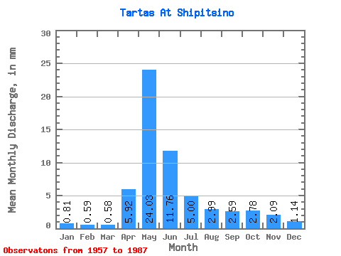
| Statistic | Jan | Feb | Mar | Apr | May | Jun | Jul | Aug | Sep | Oct | Nov | Dec | Annual |
|---|---|---|---|---|---|---|---|---|---|---|---|---|---|
| Mean | 0.81 | 0.59 | 0.58 | 5.92 | 24.03 | 11.76 | 5.00 | 2.99 | 2.59 | 2.78 | 2.09 | 1.14 | 59.98 |
| Standard Deviation | 0.50 | 0.28 | 0.19 | 5.81 | 15.14 | 12.66 | 7.03 | 4.21 | 3.92 | 3.20 | 1.86 | 0.83 | 44.50 |
| Min | 0.32 | 0.28 | 0.33 | 0.80 | 1.25 | 0.54 | 0.38 | 0.36 | 0.51 | 0.54 | 0.47 | 0.36 | 6.80 |
| Max | 2.54 | 1.59 | 1.23 | 24.54 | 54.07 | 46.52 | 30.04 | 21.88 | 21.57 | 11.41 | 7.28 | 3.92 | 200.07 |
| Coefficient of Variation | 0.61 | 0.47 | 0.32 | 0.98 | 0.63 | 1.08 | 1.41 | 1.41 | 1.52 | 1.15 | 0.89 | 0.73 | 0.74 |
 Return to R-Arctic Net Home Page