|
|
|||||||||||||||||
| Point ID: 6993 | Downloads | Plots | Site Data | Code: 11236 |
|
|
|||||||||||||||||
| Download | |
|---|---|
| Site Descriptor Information | Site Time Series Data |
| Link to all available data | |
| View: | Time Series | All |
| Units: | mm |
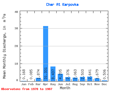
| Statistic | Jan | Feb | Mar | Apr | May | Jun | Jul | Aug | Sep | Oct | Nov | Dec | Annual |
|---|---|---|---|---|---|---|---|---|---|---|---|---|---|
| Mean | 0.17 | 0.09 | 1.87 | 31.33 | 8.44 | 4.21 | 2.38 | 2.06 | 2.50 | 2.64 | 1.68 | 0.51 | 6.23 |
| Standard Deviation | 0.12 | 0.14 | 3.07 | 24.94 | 7.83 | 3.75 | 1.87 | 1.65 | 2.57 | 1.63 | 0.64 | 0.39 | 4.08 |
| Min | 0.00 | 0.00 | 0.00 | 6.45 | 0.66 | 0.26 | 0.11 | 0.12 | 0.02 | 0.27 | 0.24 | 0.03 | 3.34 |
| Max | 0.31 | 0.25 | 7.30 | 82.50 | 23.30 | 9.46 | 5.75 | 4.95 | 9.00 | 5.44 | 2.39 | 1.19 | 9.12 |
| Coefficient of Variation | 0.69 | 1.68 | 1.64 | 0.80 | 0.93 | 0.89 | 0.79 | 0.80 | 1.03 | 0.62 | 0.38 | 0.77 | 0.66 |
 Return to R-Arctic Net Home Page