|
|
|||||||||||||||||
| Point ID: 6988 | Downloads | Plots | Site Data | Code: 11207 |
|
|
|||||||||||||||||
| Download | |
|---|---|
| Site Descriptor Information | Site Time Series Data |
| Link to all available data | |
|
|
| View: | Statistics | Time Series |
| Units: | mm |
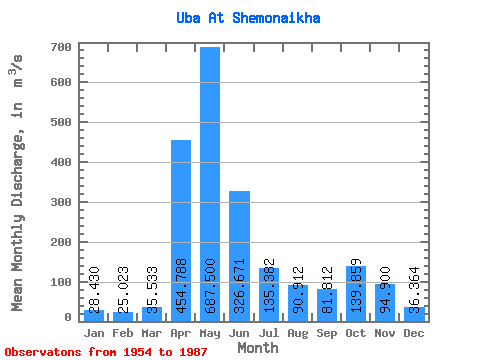
| Statistic | Jan | Feb | Mar | Apr | May | Jun | Jul | Aug | Sep | Oct | Nov | Dec | Annual |
|---|---|---|---|---|---|---|---|---|---|---|---|---|---|
| Mean | 28.43 | 25.02 | 35.53 | 454.79 | 687.50 | 326.67 | 135.38 | 90.91 | 81.81 | 139.86 | 94.90 | 36.36 | 177.79 |
| Standard Deviation | 9.05 | 7.79 | 19.15 | 145.55 | 231.82 | 188.20 | 78.47 | 55.72 | 46.28 | 79.67 | 72.02 | 12.57 | 41.14 |
| Min | 11.80 | 7.72 | 12.20 | 232.00 | 245.00 | 63.80 | 36.80 | 23.90 | 28.20 | 43.40 | 26.00 | 21.80 | 122.17 |
| Max | 46.30 | 45.20 | 120.00 | 762.00 | 1160.00 | 907.00 | 327.00 | 240.00 | 258.00 | 373.00 | 439.00 | 72.80 | 255.31 |
| Coefficient of Variation | 0.32 | 0.31 | 0.54 | 0.32 | 0.34 | 0.58 | 0.58 | 0.61 | 0.57 | 0.57 | 0.76 | 0.35 | 0.23 |
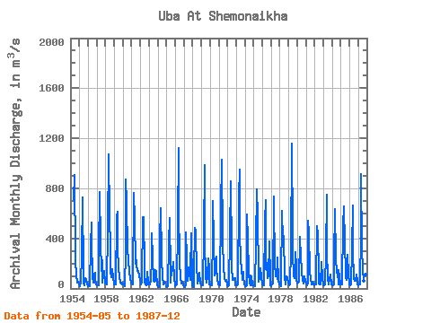
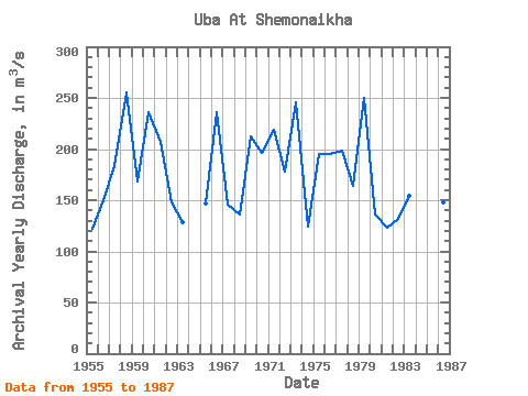
| Year | Jan | Feb | Mar | Apr | May | Jun | Jul | Aug | Sep | Oct | Nov | Dec | Annual | 1954 | 712.00 | 907.00 | 249.00 | 79.90 | 112.00 | 49.20 | 57.20 | 29.80 | 1955 | 20.60 | 22.30 | 38.80 | 267.00 | 726.00 | 108.00 | 36.80 | 23.90 | 83.80 | 65.00 | 29.30 | 44.50 | 122.17 | 1956 | 17.00 | 17.50 | 20.70 | 351.00 | 528.00 | 397.00 | 91.90 | 50.10 | 120.00 | 122.00 | 54.50 | 35.00 | 150.39 | 1957 | 28.40 | 22.30 | 26.10 | 280.00 | 768.00 | 378.00 | 140.00 | 226.00 | 43.60 | 109.00 | 143.00 | 41.20 | 183.80 | 1958 | 40.40 | 31.60 | 31.50 | 475.00 | 1070.00 | 574.00 | 327.00 | 137.00 | 92.10 | 154.00 | 88.50 | 42.60 | 255.31 | 1959 | 31.80 | 31.50 | 34.40 | 570.00 | 615.00 | 316.00 | 159.00 | 94.10 | 49.90 | 49.60 | 38.50 | 32.40 | 168.52 | 1960 | 37.70 | 29.80 | 20.60 | 288.00 | 868.00 | 685.00 | 302.00 | 240.00 | 115.00 | 120.00 | 86.50 | 36.80 | 235.78 | 1961 | 39.00 | 30.30 | 51.30 | 762.00 | 554.00 | 196.00 | 228.00 | 186.00 | 137.00 | 137.00 | 94.10 | 72.80 | 207.29 | 1962 | 46.30 | 35.60 | 56.60 | 568.00 | 572.00 | 172.00 | 49.40 | 31.70 | 28.20 | 134.00 | 43.90 | 35.30 | 147.75 | 1963 | 36.90 | 29.40 | 68.40 | 232.00 | 444.00 | 248.00 | 58.70 | 56.70 | 60.30 | 146.00 | 136.00 | 25.00 | 128.45 | 1964 | 13.20 | 7.72 | 12.20 | 391.00 | 640.00 | 265.00 | 67.00 | 50.70 | 30.90 | 43.40 | 1965 | 19.00 | 18.40 | 20.10 | 368.00 | 563.00 | 121.00 | 47.00 | 144.00 | 140.00 | 209.00 | 92.70 | 21.80 | 147.00 | 1966 | 20.30 | 21.60 | 33.80 | 513.00 | 1120.00 | 653.00 | 214.00 | 82.90 | 42.30 | 47.50 | 56.70 | 25.10 | 235.85 | 1967 | 13.10 | 9.00 | 33.90 | 447.00 | 245.00 | 63.80 | 171.00 | 112.00 | 68.00 | 126.00 | 439.00 | 24.20 | 146.00 | 1968 | 11.80 | 9.63 | 120.00 | 483.00 | 457.00 | 124.00 | 116.00 | 42.10 | 75.60 | 124.00 | 38.50 | 35.00 | 136.39 | 1969 | 21.60 | 27.40 | 25.70 | 426.00 | 987.00 | 380.00 | 95.40 | 48.70 | 98.60 | 239.00 | 162.00 | 30.90 | 211.86 | 1970 | 32.10 | 24.50 | 27.80 | 429.00 | 699.00 | 383.00 | 106.00 | 120.00 | 258.00 | 163.00 | 85.40 | 29.60 | 196.45 | 1971 | 24.30 | 27.40 | 33.80 | 631.00 | 1030.00 | 392.00 | 145.00 | 112.00 | 75.90 | 63.40 | 69.30 | 22.80 | 218.91 | 1972 | 33.30 | 20.70 | 22.80 | 430.00 | 859.00 | 280.00 | 170.00 | 67.30 | 81.90 | 67.30 | 79.90 | 25.60 | 178.15 | 1973 | 34.20 | 27.90 | 34.10 | 738.00 | 949.00 | 446.00 | 228.00 | 161.00 | 70.20 | 134.00 | 90.30 | 40.30 | 246.08 | 1974 | 19.10 | 18.40 | 22.90 | 588.00 | 391.00 | 131.00 | 43.00 | 25.70 | 104.00 | 99.10 | 26.00 | 28.20 | 124.70 | 1975 | 26.00 | 19.20 | 18.30 | 367.00 | 793.00 | 575.00 | 109.00 | 51.90 | 92.00 | 164.00 | 98.00 | 34.10 | 195.62 | 1976 | 30.10 | 24.40 | 27.60 | 536.00 | 708.00 | 156.00 | 205.00 | 82.50 | 98.30 | 373.00 | 78.50 | 26.60 | 195.50 | 1977 | 16.10 | 29.20 | 39.40 | 733.00 | 681.00 | 206.00 | 96.70 | 154.00 | 78.60 | 248.00 | 68.40 | 35.80 | 198.85 | 1978 | 31.20 | 20.80 | 38.50 | 619.00 | 382.00 | 422.00 | 94.60 | 92.00 | 35.30 | 97.40 | 83.70 | 46.70 | 163.60 | 1979 | 34.80 | 25.90 | 29.50 | 304.00 | 1160.00 | 441.00 | 276.00 | 107.00 | 83.90 | 287.00 | 186.00 | 64.90 | 250.00 | 1980 | 42.10 | 45.20 | 53.90 | 412.00 | 371.00 | 281.00 | 115.00 | 73.50 | 41.50 | 50.20 | 100.00 | 52.70 | 136.51 | 1981 | 37.10 | 28.60 | 45.40 | 540.00 | 440.00 | 139.00 | 66.10 | 38.30 | 31.30 | 51.10 | 35.60 | 27.40 | 123.33 | 1982 | 34.20 | 34.70 | 31.20 | 498.00 | 425.00 | 130.00 | 37.60 | 29.40 | 34.90 | 208.00 | 83.60 | 30.90 | 131.46 | 1983 | 28.00 | 23.20 | 32.10 | 273.00 | 750.00 | 311.00 | 72.70 | 32.60 | 77.80 | 106.00 | 110.00 | 33.70 | 154.18 | 1984 | 26.80 | 22.40 | 31.00 | 236.00 | 632.00 | 243.00 | 124.00 | 131.00 | 33.20 | 150.00 | 86.70 | 33.50 | 145.80 | 1985 | 35.80 | 32.50 | 30.40 | 505.00 | 658.00 | 356.00 | 136.00 | 88.80 | 65.50 | 270.00 | 119.00 | 35.00 | 194.33 | 1986 | 29.80 | 27.70 | 29.60 | 314.00 | 664.00 | 306.00 | 79.10 | 60.20 | 60.00 | 111.00 | 59.90 | 31.50 | 147.73 | 1987 | 26.10 | 29.00 | 30.20 | 434.00 | 914.00 | 321.00 | 147.00 | 58.00 | 162.00 | 238.00 | 111.00 | 68.30 | 211.55 |
|---|
 Return to R-Arctic Net Home Page