|
|
|||||||||||||||||
| Point ID: 6961 | Downloads | Plots | Site Data | Code: 11078 |
|
|
|||||||||||||||||
| Download | |
|---|---|
| Site Descriptor Information | Site Time Series Data |
| Link to all available data | |
|
|
| View: | Statistics | Time Series |
| Units: | mm |
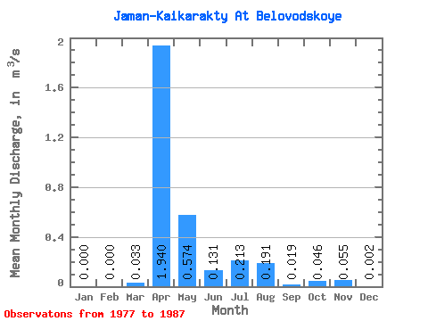
| Statistic | Jan | Feb | Mar | Apr | May | Jun | Jul | Aug | Sep | Oct | Nov | Dec | Annual |
|---|---|---|---|---|---|---|---|---|---|---|---|---|---|
| Mean | 0.00 | 0.00 | 0.03 | 1.94 | 0.57 | 0.13 | 0.21 | 0.19 | 0.02 | 0.05 | 0.06 | 0.00 | |
| Standard Deviation | 0.00 | 0.00 | 0.06 | 0.66 | 0.67 | 0.22 | 0.32 | 0.29 | 0.01 | 0.05 | 0.08 | 0.00 | |
| Min | 0.00 | 0.00 | 0.00 | 1.31 | 0.06 | 0.01 | 0.00 | 0.02 | 0.01 | 0.01 | 0.00 | 0.00 | |
| Max | 0.00 | 0.00 | 0.10 | 3.18 | 2.15 | 0.62 | 0.77 | 0.53 | 0.04 | 0.11 | 0.11 | 0.01 | |
| Coefficient of Variation | 1.73 | 0.34 | 1.17 | 1.68 | 1.49 | 1.54 | 0.69 | 1.06 | 1.41 | 1.73 |
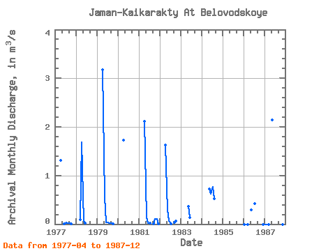
| Year | Jan | Feb | Mar | Apr | May | Jun | Jul | Aug | Sep | Oct | Nov | Dec | Annual | 1977 | 1.31 | 0.01 | 0.04 | 0.02 | 0.02 | 0.01 | 1978 | 0.10 | 1.68 | 0.06 | 0.02 | 1979 | 3.18 | 0.56 | 0.04 | 0.03 | 0.02 | 0.02 | 0.01 | 1980 | 1.73 | 1981 | 2.11 | 0.15 | 0.03 | 0.01 | 0.01 | 0.11 | 0.11 | 0.01 | 1982 | 1.63 | 0.29 | 0.06 | 0.00 | 0.04 | 0.06 | 1983 | 0.36 | 0.14 | 1984 | 0.72 | 0.62 | 0.77 | 0.53 | 1985 | 1986 | 0.00 | 0.00 | 0.00 | 0.30 | 0.42 | 0.00 | 1987 | 0.00 | 0.00 | 0.00 | 2.15 | 0.00 | 0.00 |
|---|
 Return to R-Arctic Net Home Page