|
|
|||||||||||||||||
| Point ID: 695 | Downloads | Plots | Site Data | Other Close Sites | Code: 07CD001 |
|
|
|||||||||||||||||
| Download | |
|---|---|
| Site Descriptor Information | Site Time Series Data |
| Link to all available data | |
|
|
| View: | Statistics | Time Series |
| Units: | mm |
| Statistic | Jan | Feb | Mar | Apr | May | Jun | Jul | Aug | Sep | Oct | Nov | Dec | Annual |
|---|---|---|---|---|---|---|---|---|---|---|---|---|---|
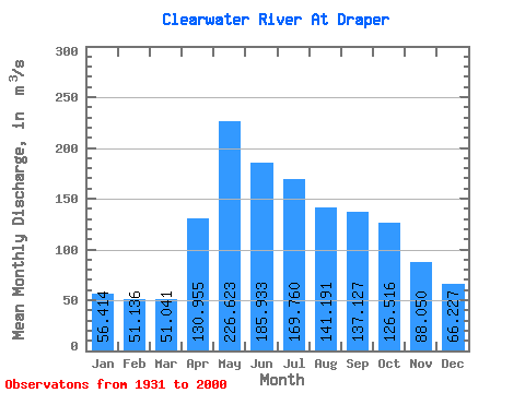
| Mean | 56.41 | 51.14 | 51.04 | 130.96 | 226.62 | 185.93 | 169.76 | 141.19 | 137.13 | 126.52 | 88.05 | 66.23 | 119.10 |
| Standard Deviation | 15.02 | 12.00 | 9.12 | 58.83 | 91.02 | 78.55 | 90.91 | 73.62 | 79.82 | 59.57 | 31.98 | 20.46 | 35.16 |
| Min | 32.10 | 29.30 | 29.70 | 49.90 | 97.80 | 78.50 | 60.30 | 48.10 | 44.10 | 47.60 | 40.10 | 38.50 | 56.76 |
| Max | 89.90 | 78.30 | 74.90 | 311.00 | 488.00 | 478.00 | 467.00 | 348.00 | 430.00 | 282.00 | 175.00 | 120.00 | 214.98 |
| Coefficient of Variation | 0.27 | 0.23 | 0.18 | 0.45 | 0.40 | 0.42 | 0.54 | 0.52 | 0.58 | 0.47 | 0.36 | 0.31 | 0.29 |
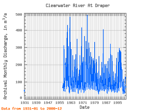
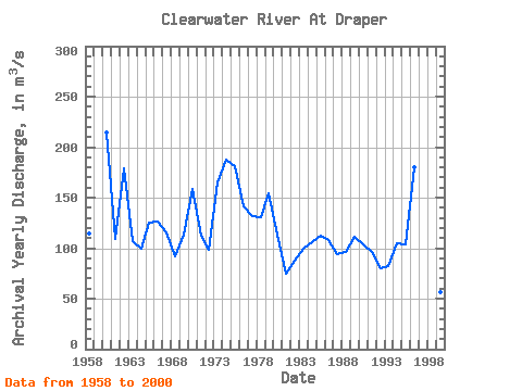
| Year | Jan | Feb | Mar | Apr | May | Jun | Jul | Aug | Sep | Oct | Nov | Dec | Annual | 1931 | 53.70 | 43.90 | 49.10 | 1957 | 68.00 | 89.80 | 80.70 | 73.00 | 1958 | 54.20 | 47.30 | 48.80 | 311.00 | 270.00 | 129.00 | 76.30 | 71.40 | 98.80 | 122.00 | 85.90 | 65.70 | 115.03 | 1959 | 51.10 | 46.10 | 46.80 | 204.00 | 212.00 | 128.00 | 109.00 | 230.00 | 237.00 | 134.00 | 96.50 | 1960 | 76.20 | 65.90 | 59.70 | 159.00 | 348.00 | 354.00 | 317.00 | 348.00 | 430.00 | 212.00 | 127.00 | 83.00 | 214.98 | 1961 | 80.80 | 73.10 | 70.60 | 98.30 | 306.00 | 168.00 | 162.00 | 104.00 | 76.40 | 68.90 | 60.30 | 43.40 | 109.32 | 1962 | 39.30 | 34.60 | 41.30 | 49.90 | 346.00 | 478.00 | 467.00 | 195.00 | 152.00 | 145.00 | 112.00 | 89.20 | 179.11 | 1963 | 72.90 | 60.50 | 57.00 | 186.00 | 290.00 | 152.00 | 94.50 | 80.10 | 88.90 | 83.70 | 71.50 | 49.70 | 107.23 | 1964 | 43.90 | 46.10 | 47.30 | 80.10 | 253.00 | 163.00 | 99.20 | 114.00 | 107.00 | 107.00 | 73.60 | 55.60 | 99.15 | 1965 | 51.90 | 43.50 | 43.60 | 87.40 | 228.00 | 203.00 | 178.00 | 157.00 | 188.00 | 149.00 | 99.70 | 74.40 | 125.29 | 1966 | 59.20 | 47.10 | 42.40 | 124.00 | 209.00 | 259.00 | 167.00 | 180.00 | 166.00 | 127.00 | 75.20 | 64.90 | 126.73 | 1967 | 69.50 | 64.90 | 57.60 | 68.30 | 348.00 | 209.00 | 148.00 | 130.00 | 83.10 | 79.30 | 69.90 | 60.10 | 115.64 | 1968 | 34.30 | 33.40 | 44.50 | 82.90 | 131.00 | 120.00 | 106.00 | 82.80 | 125.00 | 169.00 | 117.00 | 61.60 | 92.29 | 1969 | 63.30 | 53.60 | 56.50 | 253.00 | 240.00 | 152.00 | 83.00 | 68.30 | 112.00 | 138.00 | 74.90 | 67.70 | 113.53 | 1970 | 50.00 | 44.60 | 39.60 | 157.00 | 212.00 | 198.00 | 414.00 | 190.00 | 209.00 | 193.00 | 118.00 | 78.10 | 158.61 | 1971 | 63.00 | 55.50 | 55.90 | 210.00 | 218.00 | 130.00 | 242.00 | 119.00 | 80.70 | 73.30 | 56.00 | 49.00 | 112.70 | 1972 | 41.90 | 36.40 | 44.10 | 72.00 | 365.00 | 146.00 | 108.00 | 74.60 | 65.40 | 95.50 | 74.10 | 56.60 | 98.30 | 1973 | 48.50 | 49.70 | 49.40 | 124.00 | 156.00 | 275.00 | 201.00 | 336.00 | 243.00 | 247.00 | 152.00 | 95.90 | 164.79 | 1974 | 75.90 | 63.70 | 57.30 | 308.00 | 488.00 | 310.00 | 272.00 | 195.00 | 159.00 | 138.00 | 105.00 | 84.70 | 188.05 | 1975 | 73.20 | 68.10 | 61.50 | 122.00 | 297.00 | 235.00 | 327.00 | 267.00 | 274.00 | 225.00 | 135.00 | 87.80 | 181.05 | 1976 | 80.10 | 66.40 | 54.50 | 184.00 | 151.00 | 149.00 | 199.00 | 176.00 | 271.00 | 189.00 | 102.00 | 69.20 | 140.93 | 1977 | 71.80 | 65.60 | 61.90 | 146.00 | 196.00 | 245.00 | 214.00 | 157.00 | 133.00 | 129.00 | 84.00 | 72.40 | 131.31 | 1978 | 60.70 | 57.20 | 56.90 | 123.00 | 236.00 | 179.00 | 107.00 | 111.00 | 225.00 | 219.00 | 111.00 | 82.00 | 130.65 | 1979 | 69.50 | 59.40 | 54.00 | 68.20 | 330.00 | 274.00 | 208.00 | 159.00 | 207.00 | 173.00 | 130.00 | 120.00 | 154.34 | 1980 | 72.40 | 56.90 | 51.50 | 146.00 | 109.00 | 101.00 | 75.90 | 231.00 | 200.00 | 156.00 | 99.00 | 58.70 | 113.12 | 1981 | 49.30 | 52.90 | 57.90 | 117.00 | 151.00 | 107.00 | 115.00 | 66.60 | 44.10 | 50.00 | 47.30 | 39.30 | 74.78 | 1982 | 37.80 | 29.30 | 29.70 | 73.40 | 249.00 | 134.00 | 102.00 | 119.00 | 95.50 | 79.30 | 57.90 | 45.90 | 87.73 | 1983 | 49.90 | 56.10 | 55.80 | 127.00 | 137.00 | 133.00 | 131.00 | 127.00 | 120.00 | 105.00 | 86.80 | 61.40 | 99.17 | 1984 | 52.00 | 51.00 | 52.70 | 135.00 | 150.00 | 214.00 | 150.00 | 101.00 | 100.00 | 110.00 | 86.80 | 63.40 | 105.49 | 1985 | 52.30 | 51.60 | 51.80 | 127.00 | 404.00 | 182.00 | 122.00 | 81.60 | 76.50 | 87.30 | 69.40 | 48.90 | 112.87 | 1986 | 48.40 | 47.70 | 47.80 | 119.00 | 186.00 | 127.00 | 202.00 | 186.00 | 99.50 | 88.10 | 79.60 | 62.40 | 107.79 | 1987 | 55.90 | 57.40 | 57.40 | 179.00 | 204.00 | 155.00 | 85.10 | 85.10 | 73.70 | 71.30 | 54.00 | 47.10 | 93.75 | 1988 | 37.90 | 33.60 | 41.80 | 74.70 | 143.00 | 139.00 | 219.00 | 124.00 | 120.00 | 86.90 | 74.60 | 66.60 | 96.76 | 1989 | 52.50 | 49.20 | 45.30 | 82.00 | 236.00 | 196.00 | 187.00 | 105.00 | 102.00 | 126.00 | 85.20 | 74.90 | 111.76 | 1990 | 67.10 | 59.00 | 60.20 | 157.00 | 320.00 | 200.00 | 106.00 | 61.80 | 56.90 | 61.20 | 49.90 | 48.90 | 104.00 | 1991 | 42.50 | 42.90 | 42.70 | 114.00 | 123.00 | 254.00 | 188.00 | 89.70 | 75.00 | 64.80 | 65.30 | 48.90 | 95.90 | 1992 | 48.90 | 48.10 | 47.60 | 108.00 | 159.00 | 139.00 | 79.60 | 58.00 | 75.20 | 89.60 | 65.60 | 45.50 | 80.34 | 1993 | 38.90 | 38.20 | 45.20 | 91.60 | 122.00 | 78.50 | 85.00 | 148.00 | 108.00 | 100.00 | 76.30 | 60.40 | 82.67 | 1994 | 48.80 | 42.90 | 47.00 | 148.00 | 186.00 | 204.00 | 237.00 | 112.00 | 68.90 | 75.70 | 51.00 | 38.50 | 104.98 | 1995 | 45.90 | 42.10 | 42.40 | 84.00 | 130.00 | 109.00 | 109.00 | 272.00 | 161.00 | 113.00 | 74.40 | 58.90 | 103.47 | 1996 | 50.50 | 47.00 | 50.60 | 135.00 | 294.00 | 229.00 | 249.00 | 271.00 | 266.00 | 282.00 | 175.00 | 110.00 | 179.93 | 1997 | 89.90 | 71.90 | 67.40 | 127.00 | 277.00 | 266.00 | 250.00 | 172.00 | 200.00 | 211.00 | 163.00 | 117.00 | 167.68 | 1998 | 88.60 | 78.30 | 74.90 | 172.00 | 130.00 | 82.20 | 98.80 | 63.10 | 47.60 | 52.40 | 52.90 | 41.70 | 81.88 | 1999 | 32.10 | 33.50 | 39.80 | 92.20 | 115.00 | 85.40 | 60.30 | 48.10 | 47.40 | 47.60 | 40.10 | 39.60 | 56.76 | 2000 | 35.70 | 33.80 | 36.00 | 77.10 | 97.80 | 120.00 | 130.00 | 125.00 | 104.00 | 100.00 | 71.30 | 55.50 | 82.18 |
|---|
| Other Close Sites | ||||||
|---|---|---|---|---|---|---|
| PointID | Latitude | Longitude | Drainage Area | Source | Name | |
| 703 | "ATHABASCA RIVER BELOW MCMURRAY" | 56.78 | 1329065 | Hydat | ||
 Return to R-Arctic Net Home Page