|
|
|||||||||||||||||
| Point ID: 6943 | Downloads | Plots | Site Data | Code: 11001 |
|
|
|||||||||||||||||
| Download | |
|---|---|
| Site Descriptor Information | Site Time Series Data |
| Link to all available data | |
| View: | Time Series | All |
| Units: | m3/s |
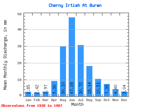
| Statistic | Jan | Feb | Mar | Apr | May | Jun | Jul | Aug | Sep | Oct | Nov | Dec | Annual |
|---|---|---|---|---|---|---|---|---|---|---|---|---|---|
| Mean | 2.85 | 2.44 | 2.97 | 9.30 | 30.10 | 47.28 | 30.71 | 18.14 | 10.51 | 7.35 | 4.40 | 3.04 | 168.61 |
| Standard Deviation | 0.57 | 0.49 | 0.69 | 3.65 | 10.08 | 18.21 | 14.29 | 6.24 | 4.34 | 3.19 | 1.71 | 0.88 | 48.28 |
| Min | 1.91 | 1.62 | 2.00 | 2.42 | 9.20 | 13.17 | 6.61 | 8.43 | 4.26 | 3.50 | 2.48 | 1.82 | 75.40 |
| Max | 4.16 | 3.85 | 5.08 | 18.92 | 50.78 | 88.10 | 73.78 | 37.89 | 23.51 | 23.00 | 13.54 | 5.51 | 270.02 |
| Coefficient of Variation | 0.20 | 0.20 | 0.23 | 0.39 | 0.34 | 0.39 | 0.47 | 0.34 | 0.41 | 0.43 | 0.39 | 0.29 | 0.29 |
 Return to R-Arctic Net Home Page