|
|
|||||||||||||||||
| Point ID: 6932 | Downloads | Plots | Site Data | Code: 10620 |
|
|
|||||||||||||||||
| Download | |
|---|---|
| Site Descriptor Information | Site Time Series Data |
| Link to all available data | |
| View: | Time Series | All |
| Units: | m3/s |
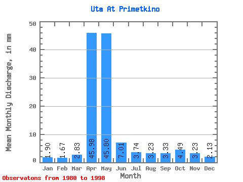
| Statistic | Jan | Feb | Mar | Apr | May | Jun | Jul | Aug | Sep | Oct | Nov | Dec | Annual |
|---|---|---|---|---|---|---|---|---|---|---|---|---|---|
| Mean | 1.90 | 1.69 | 2.82 | 45.98 | 45.79 | 7.02 | 3.74 | 3.23 | 3.33 | 4.49 | 3.22 | 2.13 | 125.21 |
| Standard Deviation | 0.69 | 0.70 | 2.46 | 27.32 | 29.39 | 3.47 | 1.42 | 1.07 | 1.48 | 2.38 | 1.69 | 0.65 | 47.78 |
| Min | 0.82 | 0.60 | 1.22 | 8.55 | 6.70 | 2.59 | 1.61 | 1.74 | 1.56 | 1.47 | 1.43 | 0.94 | 47.54 |
| Max | 3.08 | 3.17 | 10.71 | 105.88 | 93.46 | 13.61 | 6.43 | 4.95 | 6.22 | 10.71 | 7.91 | 3.08 | 202.68 |
| Coefficient of Variation | 0.36 | 0.41 | 0.87 | 0.59 | 0.64 | 0.49 | 0.38 | 0.33 | 0.45 | 0.53 | 0.53 | 0.30 | 0.38 |
 Return to R-Arctic Net Home Page