|
|
|||||||||||||||||
| Point ID: 6925 | Downloads | Plots | Site Data | Code: 10590 |
|
|
|||||||||||||||||
| Download | |
|---|---|
| Site Descriptor Information | Site Time Series Data |
| Link to all available data | |
| View: | Time Series | All |
| Units: | m3/s |
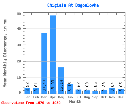
| Statistic | Jan | Feb | Mar | Apr | May | Jun | Jul | Aug | Sep | Oct | Nov | Dec | Annual |
|---|---|---|---|---|---|---|---|---|---|---|---|---|---|
| Mean | 3.52 | 3.64 | 37.47 | 48.03 | 16.14 | 6.13 | 2.61 | 2.10 | 1.85 | 2.32 | 3.64 | 3.05 | 179.83 |
| Standard Deviation | 6.03 | 13.65 | 5.22 | 1.43 | 0.89 | 0.75 | 0.90 | ||||||
| Min | 3.52 | 3.64 | 37.47 | 43.77 | 1.88 | 0.69 | 0.18 | 0.16 | 0.14 | 1.64 | 3.64 | 3.05 | 179.83 |
| Max | 3.52 | 3.64 | 37.47 | 52.30 | 42.87 | 18.19 | 5.40 | 3.29 | 2.73 | 4.11 | 3.64 | 3.05 | 179.83 |
| Coefficient of Variation | 0.13 | 0.85 | 0.85 | 0.55 | 0.43 | 0.41 | 0.39 |
 Return to R-Arctic Net Home Page