|
|
|||||||||||||||||
| Point ID: 6889 | Downloads | Plots | Site Data | Code: 10539 |
|
|
|||||||||||||||||
| Download | |
|---|---|
| Site Descriptor Information | Site Time Series Data |
| Link to all available data | |
| View: | Time Series | All |
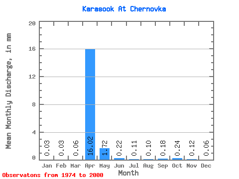
| Units: | m3/s |
| Statistic | Jan | Feb | Mar | Apr | May | Jun | Jul | Aug | Sep | Oct | Nov | Dec | Annual |
|---|---|---|---|---|---|---|---|---|---|---|---|---|---|
| Mean | 0.03 | 0.03 | 0.06 | 16.02 | 1.72 | 0.22 | 0.11 | 0.10 | 0.17 | 0.24 | 0.12 | 0.06 | 20.63 |
| Standard Deviation | 0.02 | 0.02 | 0.09 | 12.61 | 2.12 | 0.20 | 0.09 | 0.09 | 0.17 | 0.17 | 0.06 | 0.04 | 17.54 |
| Min | 0.00 | 0.00 | 0.00 | 1.40 | 0.33 | 0.04 | 0.00 | 0.01 | 0.02 | 0.04 | 0.00 | 0.01 | 3.38 |
| Max | 0.07 | 0.06 | 0.36 | 43.77 | 8.84 | 0.82 | 0.34 | 0.31 | 0.71 | 0.67 | 0.21 | 0.15 | 55.15 |
| Coefficient of Variation | 0.73 | 0.69 | 1.50 | 0.79 | 1.24 | 0.91 | 0.82 | 0.95 | 0.97 | 0.72 | 0.50 | 0.64 | 0.85 |
 Return to R-Arctic Net Home Page