|
|
|||||||||||||||||
| Point ID: 6864 | Downloads | Plots | Site Data | Code: 10485 |
|
|
|||||||||||||||||
| Download | |
|---|---|
| Site Descriptor Information | Site Time Series Data |
| Link to all available data | |
| View: | Time Series | All |
| Units: | m3/s |
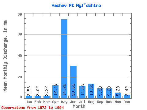
| Statistic | Jan | Feb | Mar | Apr | May | Jun | Jul | Aug | Sep | Oct | Nov | Dec | Annual |
|---|---|---|---|---|---|---|---|---|---|---|---|---|---|
| Mean | 2.56 | 2.04 | 2.32 | 12.19 | 74.25 | 30.65 | 11.69 | 13.65 | 9.37 | 9.22 | 5.27 | 3.41 | 172.48 |
| Standard Deviation | 0.79 | 0.56 | 0.70 | 9.90 | 28.79 | 16.47 | 10.09 | 14.13 | 6.53 | 5.68 | 2.29 | 1.14 | 60.24 |
| Min | 1.09 | 1.02 | 1.19 | 2.42 | 42.97 | 5.53 | 3.33 | 3.21 | 3.00 | 4.05 | 2.07 | 1.67 | 86.26 |
| Max | 3.93 | 3.36 | 3.93 | 39.63 | 161.87 | 58.18 | 36.42 | 53.32 | 24.54 | 22.38 | 10.14 | 6.19 | 290.24 |
| Coefficient of Variation | 0.31 | 0.28 | 0.30 | 0.81 | 0.39 | 0.54 | 0.86 | 1.03 | 0.70 | 0.62 | 0.43 | 0.34 | 0.35 |
 Return to R-Arctic Net Home Page