|
|
|||||||||||||||||
| Point ID: 6863 | Downloads | Plots | Site Data | Code: 10483 |
|
|
|||||||||||||||||
| Download | |
|---|---|
| Site Descriptor Information | Site Time Series Data |
| Link to all available data | |
|

|
| View: | Statistics | Time Series |
| Units: | mm |
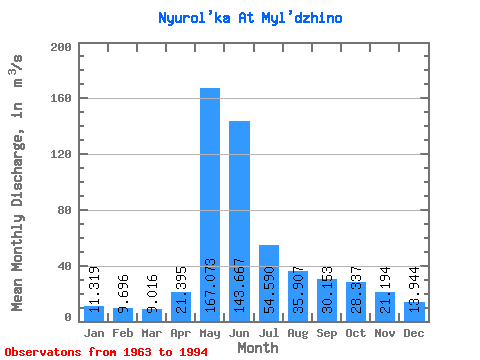
| Statistic | Jan | Feb | Mar | Apr | May | Jun | Jul | Aug | Sep | Oct | Nov | Dec | Annual |
|---|---|---|---|---|---|---|---|---|---|---|---|---|---|
| Mean | 11.32 | 9.70 | 9.02 | 21.39 | 167.07 | 143.67 | 54.59 | 35.91 | 30.15 | 28.34 | 21.19 | 13.94 | 45.51 |
| Standard Deviation | 2.91 | 1.95 | 1.48 | 11.51 | 44.20 | 65.76 | 41.49 | 25.02 | 18.91 | 12.28 | 8.78 | 4.96 | 12.80 |
| Min | 7.52 | 6.45 | 5.67 | 8.17 | 68.90 | 29.60 | 15.90 | 12.30 | 13.10 | 13.80 | 10.00 | 6.67 | 24.45 |
| Max | 20.50 | 15.10 | 12.00 | 51.50 | 241.00 | 252.00 | 189.00 | 114.00 | 87.60 | 49.90 | 43.00 | 25.50 | 76.05 |
| Coefficient of Variation | 0.26 | 0.20 | 0.16 | 0.54 | 0.27 | 0.46 | 0.76 | 0.70 | 0.63 | 0.43 | 0.41 | 0.36 | 0.28 |
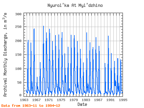
| Year | Jan | Feb | Mar | Apr | May | Jun | Jul | Aug | Sep | Oct | Nov | Dec | Annual | 1963 | 22.60 | 16.20 | 1964 | 16.80 | 15.10 | 11.90 | 12.90 | 185.00 | 202.00 | 44.20 | 21.60 | 23.00 | 22.00 | 17.10 | 12.90 | 48.71 | 1965 | 12.30 | 10.60 | 9.42 | 15.10 | 192.00 | 133.00 | 20.20 | 35.30 | 54.80 | 43.90 | 24.80 | 15.00 | 47.20 | 1966 | 10.70 | 10.00 | 10.70 | 11.50 | 239.00 | 243.00 | 53.00 | 22.00 | 19.60 | 17.10 | 10.00 | 8.37 | 54.58 | 1967 | 7.78 | 7.55 | 8.31 | 30.10 | 68.90 | 41.50 | 27.50 | 35.00 | 18.40 | 20.90 | 17.40 | 10.10 | 24.45 | 1968 | 8.95 | 8.58 | 8.84 | 20.60 | 122.00 | 74.60 | 35.30 | 22.00 | 17.20 | 15.10 | 11.70 | 8.44 | 29.44 | 1969 | 7.88 | 6.45 | 5.67 | 9.92 | 123.00 | 252.00 | 128.00 | 74.40 | 58.70 | 48.40 | 36.80 | 10.40 | 63.47 | 1970 | 10.90 | 11.50 | 8.34 | 27.40 | 169.00 | 228.00 | 189.00 | 114.00 | 66.70 | 31.50 | 32.60 | 23.60 | 76.05 | 1971 | 12.80 | 10.30 | 8.20 | 25.60 | 241.00 | 211.00 | 44.90 | 16.50 | 15.80 | 16.00 | 18.30 | 15.30 | 52.98 | 1972 | 10.60 | 7.60 | 7.59 | 23.10 | 197.00 | 133.00 | 127.00 | 49.10 | 34.50 | 33.40 | 24.80 | 19.70 | 55.62 | 1973 | 16.20 | 11.00 | 10.70 | 48.40 | 219.00 | 141.00 | 58.60 | 56.30 | 33.40 | 44.60 | 27.00 | 18.50 | 57.06 | 1974 | 13.20 | 9.48 | 8.24 | 51.50 | 221.00 | 114.00 | 37.60 | 19.40 | 31.30 | 25.40 | 16.90 | 12.10 | 46.68 | 1975 | 10.80 | 10.30 | 10.70 | 21.80 | 189.00 | 230.00 | 63.60 | 43.50 | 56.70 | 41.30 | 23.70 | 14.70 | 59.67 | 1976 | 12.50 | 9.57 | 8.07 | 20.80 | 153.00 | 49.90 | 54.40 | 75.70 | 22.20 | 18.20 | 12.20 | 11.80 | 37.36 | 1977 | 10.30 | 7.85 | 6.58 | 29.70 | 177.00 | 60.30 | 24.40 | 18.50 | 19.10 | 28.10 | 27.10 | 19.50 | 35.70 | 1978 | 14.80 | 11.40 | 10.30 | 16.00 | 220.00 | 128.00 | 20.70 | 15.40 | 15.90 | 16.80 | 17.80 | 14.00 | 41.76 | 1979 | 9.60 | 8.80 | 7.06 | 8.17 | 195.00 | 219.00 | 132.00 | 51.40 | 37.80 | 36.20 | 43.00 | 25.30 | 64.44 | 1980 | 13.80 | 11.60 | 9.96 | 19.60 | 197.00 | 116.00 | 32.40 | 48.80 | 33.90 | 25.40 | 19.10 | 12.40 | 45.00 | 1981 | 11.50 | 10.40 | 9.69 | 34.80 | 169.00 | 101.00 | 33.20 | 20.30 | 14.40 | 13.80 | 10.20 | 9.35 | 36.47 | 1982 | 8.51 | 7.71 | 7.65 | 24.90 | 121.00 | 52.20 | 20.50 | 14.40 | 13.10 | 20.00 | 17.40 | 13.20 | 26.71 | 1983 | 10.90 | 10.60 | 10.50 | 15.50 | 174.00 | 228.00 | 44.30 | 15.60 | 24.60 | 45.80 | 38.20 | 25.50 | 53.62 | 1984 | 20.50 | 14.30 | 12.00 | 13.40 | 135.00 | 193.00 | 53.10 | 27.90 | 25.80 | 32.10 | 23.80 | 9.98 | 46.74 | 1985 | 9.70 | 9.81 | 8.81 | 18.60 | 162.00 | 176.00 | 87.10 | 38.10 | 22.40 | 19.90 | 15.50 | 12.20 | 48.34 | 1986 | 10.90 | 8.74 | 8.69 | 13.70 | 123.00 | 211.00 | 98.90 | 90.30 | 87.60 | 49.90 | 31.10 | 18.20 | 62.67 | 1987 | 12.40 | 11.30 | 10.40 | 15.80 | 180.00 | 144.00 | 42.20 | 19.30 | 13.90 | 20.40 | 12.10 | 10.20 | 41.00 | 1989 | 8.84 | 8.85 | 8.99 | 11.00 | 119.00 | 88.90 | 17.20 | 12.30 | 14.60 | 16.60 | 12.30 | 9.70 | 27.36 | 1990 | 8.56 | 8.12 | 9.19 | 15.40 | 217.00 | 130.00 | 29.10 | 22.90 | 16.90 | 16.80 | 14.10 | 9.25 | 41.44 | 1991 | 9.74 | 8.55 | 9.27 | 47.60 | 154.00 | 29.60 | 15.90 | 19.80 | 17.60 | 16.00 | 10.80 | 6.67 | 28.79 | 1992 | 7.52 | 7.84 | 8.64 | 9.25 | 82.30 | 126.00 | 39.00 | 38.50 | 56.20 | 47.90 | 25.90 | 12.20 | 38.44 | 1993 | 9.48 | 7.38 | 7.84 | 14.10 | 136.00 | 136.00 | 39.20 | 17.20 | 23.40 | 46.40 | 27.90 | 17.00 | 40.16 | 1994 | 11.10 | 9.59 | 8.24 | 15.60 | 132.00 | 118.00 | 25.20 | 21.70 | 15.10 | 20.20 | 14.80 | 10.50 | 33.50 |
|---|
 Return to R-Arctic Net Home Page