|
|
|||||||||||||||||
| Point ID: 6766 | Downloads | Plots | Site Data | Code: 10264 |
|
|
|||||||||||||||||
| Download | |
|---|---|
| Site Descriptor Information | Site Time Series Data |
| Link to all available data | |
|
|
| View: | Statistics | Time Series |
| Units: | mm |
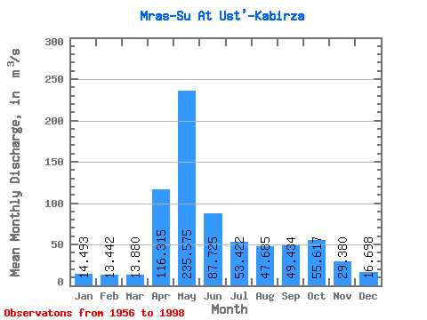
| Statistic | Jan | Feb | Mar | Apr | May | Jun | Jul | Aug | Sep | Oct | Nov | Dec | Annual |
|---|---|---|---|---|---|---|---|---|---|---|---|---|---|
| Mean | 14.49 | 13.44 | 13.88 | 116.31 | 235.57 | 87.72 | 53.42 | 47.69 | 49.43 | 55.62 | 29.38 | 16.70 | 61.16 |
| Standard Deviation | 5.10 | 4.17 | 4.56 | 53.36 | 78.57 | 41.02 | 30.42 | 25.29 | 21.57 | 25.03 | 12.66 | 9.23 | 11.78 |
| Min | 6.11 | 7.67 | 7.51 | 30.60 | 120.00 | 35.30 | 3.60 | 15.80 | 17.50 | 19.60 | 10.30 | 2.10 | 38.94 |
| Max | 28.70 | 27.80 | 28.60 | 284.00 | 492.00 | 214.00 | 151.00 | 146.00 | 104.00 | 109.00 | 67.60 | 53.00 | 88.58 |
| Coefficient of Variation | 0.35 | 0.31 | 0.33 | 0.46 | 0.33 | 0.47 | 0.57 | 0.53 | 0.44 | 0.45 | 0.43 | 0.55 | 0.19 |
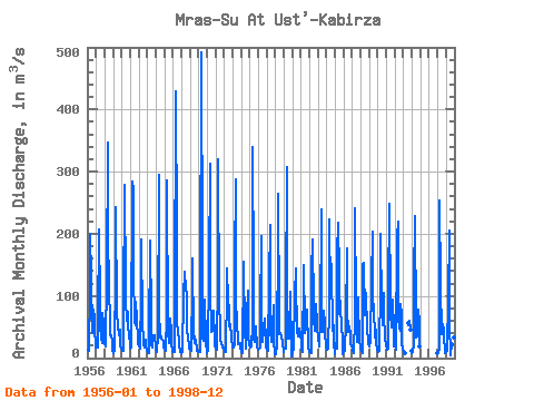
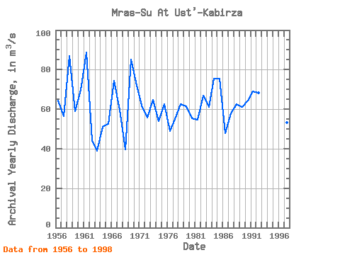
| Year | Jan | Feb | Mar | Apr | May | Jun | Jul | Aug | Sep | Oct | Nov | Dec | Annual | 1956 | 13.00 | 13.10 | 11.20 | 114.00 | 200.00 | 128.00 | 42.40 | 39.80 | 78.40 | 65.10 | 43.00 | 24.00 | 64.33 | 1957 | 17.40 | 18.70 | 17.00 | 57.80 | 207.00 | 90.90 | 54.20 | 32.10 | 23.70 | 72.50 | 55.60 | 31.80 | 56.56 | 1958 | 22.30 | 20.10 | 19.00 | 134.00 | 346.00 | 214.00 | 102.00 | 71.00 | 37.00 | 37.30 | 27.80 | 14.00 | 87.04 | 1959 | 8.86 | 10.40 | 11.50 | 139.00 | 243.00 | 71.60 | 55.10 | 50.40 | 36.00 | 45.10 | 19.60 | 16.50 | 58.92 | 1960 | 11.40 | 11.80 | 11.80 | 80.30 | 279.00 | 111.00 | 91.80 | 59.20 | 74.10 | 46.00 | 42.20 | 18.50 | 69.76 | 1961 | 15.10 | 17.20 | 23.50 | 284.00 | 269.00 | 139.00 | 56.20 | 52.10 | 90.70 | 61.50 | 29.60 | 25.00 | 88.58 | 1962 | 19.50 | 15.20 | 16.10 | 103.00 | 190.00 | 57.80 | 28.30 | 20.60 | 17.50 | 29.20 | 21.40 | 11.00 | 44.13 | 1963 | 7.96 | 7.75 | 7.51 | 30.60 | 189.00 | 65.10 | 21.00 | 17.10 | 35.90 | 33.70 | 36.20 | 15.50 | 38.94 | 1964 | 12.90 | 9.91 | 13.40 | 32.30 | 294.00 | 76.20 | 32.40 | 34.90 | 32.20 | 29.30 | 28.60 | 18.40 | 51.21 | 1965 | 14.00 | 12.40 | 11.20 | 69.30 | 286.00 | 44.00 | 24.40 | 23.70 | 64.30 | 43.70 | 24.60 | 10.60 | 52.35 | 1966 | 9.35 | 10.40 | 10.20 | 78.00 | 429.00 | 192.00 | 53.50 | 45.00 | 25.80 | 21.90 | 10.30 | 8.29 | 74.48 | 1967 | 9.88 | 10.50 | 11.30 | 100.00 | 138.00 | 126.00 | 123.00 | 90.30 | 40.30 | 38.00 | 14.90 | 14.60 | 59.73 | 1968 | 13.00 | 11.20 | 14.60 | 115.00 | 160.00 | 35.30 | 23.90 | 34.90 | 24.20 | 19.60 | 11.50 | 10.00 | 39.43 | 1969 | 12.20 | 10.60 | 10.70 | 95.00 | 492.00 | 161.00 | 33.40 | 27.10 | 52.80 | 94.00 | 25.10 | 8.77 | 85.22 | 1970 | 15.50 | 14.70 | 12.20 | 143.00 | 313.00 | 112.00 | 42.50 | 44.60 | 59.70 | 76.20 | 30.80 | 18.70 | 73.58 | 1971 | 15.90 | 14.80 | 12.80 | 135.00 | 319.00 | 79.10 | 58.60 | 29.80 | 21.80 | 19.70 | 16.50 | 17.70 | 61.73 | 1972 | 11.90 | 10.20 | 10.20 | 110.00 | 145.00 | 63.90 | 117.00 | 52.10 | 46.10 | 54.60 | 32.40 | 17.00 | 55.87 | 1973 | 20.20 | 17.40 | 22.40 | 154.00 | 288.00 | 101.00 | 49.90 | 37.40 | 22.10 | 21.60 | 24.00 | 18.50 | 64.71 | 1974 | 9.69 | 7.67 | 8.32 | 152.00 | 155.00 | 42.90 | 22.10 | 15.80 | 70.00 | 109.00 | 34.70 | 21.40 | 54.05 | 1975 | 20.90 | 16.90 | 18.10 | 51.20 | 339.00 | 132.00 | 31.80 | 25.80 | 30.00 | 51.70 | 17.80 | 13.70 | 62.41 | 1976 | 13.00 | 14.70 | 16.90 | 71.50 | 196.00 | 43.20 | 26.40 | 56.50 | 36.40 | 63.90 | 29.30 | 18.80 | 48.88 | 1977 | 13.40 | 10.90 | 13.80 | 127.00 | 214.00 | 45.30 | 25.10 | 40.00 | 51.90 | 84.40 | 28.40 | 5.51 | 54.98 | 1978 | 6.11 | 11.60 | 15.50 | 200.00 | 265.00 | 63.00 | 39.10 | 41.00 | 35.60 | 37.60 | 24.90 | 9.51 | 62.41 | 1979 | 16.00 | 17.50 | 14.70 | 98.00 | 308.00 | 59.60 | 31.00 | 31.60 | 42.30 | 107.00 | 11.80 | 2.10 | 61.63 | 1980 | 10.70 | 15.60 | 14.70 | 103.00 | 145.00 | 101.00 | 67.40 | 41.80 | 35.20 | 44.60 | 47.10 | 38.00 | 55.34 | 1981 | 24.30 | 15.00 | 9.01 | 139.00 | 149.00 | 51.60 | 40.40 | 49.70 | 70.30 | 77.50 | 19.70 | 9.81 | 54.61 | 1982 | 9.80 | 9.20 | 7.80 | 137.00 | 191.00 | 80.10 | 54.70 | 75.70 | 43.10 | 87.20 | 54.30 | 53.00 | 66.91 | 1983 | 28.70 | 21.60 | 18.40 | 62.00 | 239.00 | 72.70 | 56.20 | 42.10 | 75.40 | 54.40 | 44.80 | 16.80 | 61.01 | 1984 | 13.10 | 13.80 | 15.00 | 80.90 | 223.00 | 103.00 | 151.00 | 146.00 | 44.50 | 83.40 | 24.80 | 6.31 | 75.40 | 1985 | 24.20 | 17.60 | 14.80 | 168.00 | 218.00 | 136.00 | 71.50 | 92.30 | 74.20 | 56.50 | 26.10 | 6.41 | 75.47 | 1986 | 12.40 | 13.70 | 11.00 | 58.50 | 176.00 | 78.70 | 42.00 | 48.90 | 51.20 | 39.40 | 21.80 | 19.90 | 47.79 | 1987 | 15.90 | 11.10 | 8.30 | 67.00 | 241.00 | 85.30 | 43.90 | 25.70 | 52.70 | 97.20 | 23.50 | 20.90 | 57.71 | 1988 | 17.10 | 11.70 | 8.68 | 149.00 | 154.00 | 69.60 | 94.80 | 105.00 | 43.80 | 43.70 | 30.60 | 23.80 | 62.65 | 1989 | 19.70 | 27.80 | 28.60 | 123.00 | 203.00 | 98.50 | 76.60 | 37.40 | 33.50 | 46.20 | 26.40 | 14.20 | 61.24 | 1990 | 11.90 | 9.78 | 12.00 | 115.00 | 199.00 | 82.20 | 53.30 | 58.30 | 104.00 | 73.30 | 29.90 | 24.50 | 64.43 | 1991 | 19.80 | 13.40 | 14.80 | 104.00 | 248.00 | 85.20 | 71.20 | 49.80 | 61.50 | 94.00 | 45.80 | 18.90 | 68.87 | 1992 | 18.60 | 16.50 | 13.60 | 196.00 | 219.00 | 65.40 | 48.60 | 44.60 | 87.10 | 70.10 | 24.00 | 13.90 | 68.12 | 1993 | 10.70 | 8.48 | 8.25 | 56.10 | 52.50 | 60.00 | 45.00 | 11.30 | 1994 | 8.73 | 9.54 | 20.10 | 127.00 | 229.00 | 52.40 | 33.90 | 34.80 | 77.60 | 49.20 | 67.60 | 19.50 | 60.78 | 1997 | 8.85 | 8.21 | 16.80 | 254.00 | 120.00 | 38.20 | 40.00 | 54.90 | 43.20 | 30.10 | 15.20 | 7.76 | 53.10 | 1998 | 10.30 | 12.50 | 13.30 | 95.20 | 205.00 | 55.20 | 3.60 | 22.80 | 20.70 | 25.90 | 32.60 | 9.74 | 42.24 |
|---|
 Return to R-Arctic Net Home Page