|
|
|||||||||||||||||
| Point ID: 6764 | Downloads | Plots | Site Data | Code: 10259 |
|
|
|||||||||||||||||
| Download | |
|---|---|
| Site Descriptor Information | Site Time Series Data |
| Link to all available data | |
|
|
| View: | Statistics | Time Series |
| Units: | mm |
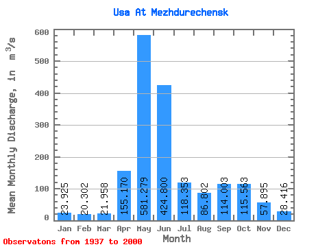
| Statistic | Jan | Feb | Mar | Apr | May | Jun | Jul | Aug | Sep | Oct | Nov | Dec | Annual |
|---|---|---|---|---|---|---|---|---|---|---|---|---|---|
| Mean | 23.93 | 20.30 | 21.96 | 155.17 | 581.28 | 424.80 | 118.35 | 86.80 | 114.00 | 115.56 | 57.90 | 28.42 | 146.35 |
| Standard Deviation | 13.78 | 12.33 | 13.94 | 86.00 | 118.45 | 232.47 | 55.12 | 40.63 | 60.73 | 47.18 | 24.14 | 14.71 | 27.69 |
| Min | 2.15 | 1.74 | 6.90 | 21.00 | 289.00 | 72.60 | 33.00 | 20.80 | 29.60 | 52.60 | 16.10 | 6.49 | 75.03 |
| Max | 98.10 | 90.70 | 110.00 | 448.00 | 884.00 | 1090.00 | 282.00 | 273.00 | 270.00 | 236.00 | 122.00 | 102.00 | 233.27 |
| Coefficient of Variation | 0.58 | 0.61 | 0.64 | 0.55 | 0.20 | 0.55 | 0.47 | 0.47 | 0.53 | 0.41 | 0.42 | 0.52 | 0.19 |
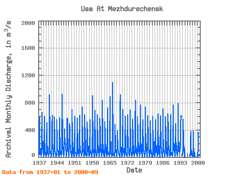
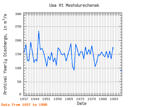
| Year | Jan | Feb | Mar | Apr | May | Jun | Jul | Aug | Sep | Oct | Nov | Dec | Annual | 1937 | 67.60 | 48.20 | 38.70 | 66.50 | 530.00 | 590.00 | 150.00 | 43.00 | 122.00 | 127.00 | 61.00 | 39.40 | 156.95 | 1938 | 30.50 | 27.10 | 32.00 | 225.00 | 653.00 | 432.00 | 199.00 | 110.00 | 157.00 | 236.00 | 61.40 | 53.30 | 184.69 | 1939 | 45.20 | 24.90 | 19.00 | 174.00 | 595.00 | 292.00 | 110.00 | 49.90 | 81.30 | 70.60 | 33.10 | 23.40 | 126.53 | 1940 | 21.70 | 15.40 | 16.50 | 224.00 | 503.00 | 263.00 | 67.40 | 50.00 | 139.00 | 105.00 | 64.60 | 28.10 | 124.81 | 1941 | 27.30 | 26.40 | 27.10 | 77.00 | 668.00 | 913.00 | 266.00 | 102.00 | 72.40 | 76.60 | 42.00 | 24.20 | 193.50 | 1942 | 14.70 | 13.60 | 20.30 | 49.40 | 449.00 | 613.00 | 204.00 | 152.00 | 128.00 | 183.00 | 76.80 | 35.20 | 161.58 | 1943 | 22.10 | 19.60 | 23.00 | 217.00 | 594.00 | 222.00 | 123.00 | 45.60 | 61.80 | 71.40 | 30.30 | 8.20 | 119.83 | 1944 | 20.60 | 21.70 | 25.20 | 252.00 | 550.00 | 240.00 | 127.00 | 87.50 | 105.00 | 85.50 | 39.60 | 16.80 | 130.91 | 1945 | 14.30 | 10.90 | 9.28 | 199.00 | 579.00 | 90.20 | 282.00 | 59.10 | 38.70 | 93.00 | 75.00 | 41.70 | 124.35 | 1946 | 35.30 | 38.30 | 40.40 | 448.00 | 672.00 | 921.00 | 183.00 | 130.00 | 90.60 | 155.00 | 62.30 | 23.30 | 233.27 | 1947 | 36.60 | 35.30 | 36.70 | 414.00 | 401.00 | 259.00 | 192.00 | 273.00 | 115.00 | 94.50 | 79.30 | 54.50 | 165.91 | 1948 | 34.50 | 20.90 | 18.90 | 149.00 | 572.00 | 555.00 | 135.00 | 110.00 | 270.00 | 95.50 | 51.90 | 33.40 | 170.51 | 1949 | 21.70 | 17.10 | 15.80 | 235.00 | 489.00 | 429.00 | 213.00 | 71.40 | 178.00 | 119.00 | 60.40 | 44.50 | 157.82 | 1950 | 21.90 | 12.40 | 10.50 | 29.00 | 699.00 | 319.00 | 56.30 | 88.10 | 210.00 | 70.10 | 29.80 | 25.30 | 130.95 | 1951 | 22.70 | 17.60 | 13.50 | 115.00 | 599.00 | 176.00 | 66.30 | 64.50 | 68.90 | 52.60 | 54.50 | 22.80 | 106.12 | 1952 | 24.90 | 18.80 | 14.50 | 21.00 | 571.00 | 490.00 | 206.00 | 97.30 | 50.40 | 120.00 | 61.60 | 26.90 | 141.87 | 1953 | 26.00 | 20.80 | 16.00 | 159.00 | 614.00 | 258.00 | 67.00 | 95.10 | 87.00 | 87.40 | 66.20 | 41.20 | 128.14 | 1954 | 32.40 | 30.10 | 27.70 | 64.90 | 289.00 | 735.00 | 157.00 | 106.00 | 208.00 | 80.10 | 111.00 | 30.60 | 155.98 | 1955 | 17.20 | 9.56 | 16.30 | 53.50 | 622.00 | 243.00 | 77.80 | 35.00 | 249.00 | 88.20 | 29.30 | 28.40 | 122.44 | 1956 | 20.50 | 18.80 | 15.20 | 157.00 | 510.00 | 316.00 | 109.00 | 83.10 | 127.00 | 163.00 | 79.40 | 33.40 | 136.03 | 1957 | 16.10 | 16.00 | 14.40 | 38.30 | 546.00 | 269.00 | 98.10 | 96.30 | 63.10 | 76.30 | 55.20 | 21.80 | 109.22 | 1958 | 11.40 | 10.00 | 7.25 | 60.60 | 561.00 | 900.00 | 161.00 | 80.20 | 76.30 | 113.00 | 72.70 | 17.00 | 172.54 | 1959 | 8.23 | 7.62 | 6.90 | 216.00 | 656.00 | 682.00 | 108.00 | 70.30 | 87.90 | 102.00 | 25.70 | 24.60 | 166.27 | 1960 | 20.60 | 20.30 | 18.40 | 86.20 | 436.00 | 620.00 | 145.00 | 92.20 | 172.00 | 65.30 | 77.50 | 39.20 | 149.39 | 1961 | 25.00 | 20.90 | 19.60 | 251.00 | 572.00 | 334.00 | 98.90 | 74.50 | 188.00 | 110.00 | 53.60 | 25.60 | 147.76 | 1962 | 22.40 | 20.40 | 26.40 | 221.00 | 837.00 | 300.00 | 80.90 | 50.10 | 62.20 | 182.00 | 22.40 | 19.90 | 153.72 | 1963 | 13.40 | 8.78 | 10.70 | 55.60 | 519.00 | 343.00 | 67.10 | 72.70 | 182.00 | 113.00 | 75.90 | 37.50 | 124.89 | 1964 | 27.10 | 19.70 | 18.10 | 89.20 | 723.00 | 507.00 | 108.00 | 62.70 | 48.50 | 62.70 | 37.40 | 32.10 | 144.62 | 1965 | 26.50 | 21.50 | 20.90 | 178.00 | 884.00 | 283.00 | 50.50 | 49.10 | 228.00 | 161.00 | 65.50 | 25.10 | 166.09 | 1966 | 15.30 | 16.90 | 18.20 | 27.80 | 708.00 | 1090.00 | 160.00 | 56.20 | 35.50 | 54.20 | 44.70 | 22.80 | 187.47 | 1967 | 14.80 | 12.30 | 14.00 | 141.00 | 476.00 | 171.00 | 112.00 | 65.80 | 110.00 | 110.00 | 38.70 | 16.50 | 106.84 | 1968 | 15.60 | 14.50 | 24.80 | 178.00 | 381.00 | 117.00 | 113.00 | 78.10 | 67.40 | 60.40 | 29.50 | 29.60 | 92.41 | 1969 | 18.80 | 15.90 | 14.20 | 48.60 | 735.00 | 912.00 | 78.40 | 98.30 | 93.60 | 145.00 | 54.60 | 17.50 | 185.99 | 1970 | 25.30 | 16.60 | 14.90 | 218.00 | 702.00 | 558.00 | 85.20 | 106.00 | 66.50 | 127.00 | 49.80 | 29.80 | 166.59 | 1971 | 21.00 | 21.50 | 16.60 | 184.00 | 596.00 | 488.00 | 141.00 | 73.40 | 63.50 | 62.90 | 34.10 | 22.30 | 143.69 | 1972 | 17.20 | 16.50 | 20.10 | 183.00 | 617.00 | 389.00 | 204.00 | 137.00 | 125.00 | 112.00 | 46.90 | 35.70 | 158.62 | 1973 | 27.50 | 24.40 | 28.60 | 218.00 | 515.00 | 692.00 | 138.00 | 102.00 | 32.60 | 58.80 | 34.10 | 30.70 | 158.47 | 1974 | 25.30 | 21.10 | 17.00 | 260.00 | 558.00 | 234.00 | 55.90 | 44.90 | 168.00 | 140.00 | 43.30 | 28.20 | 132.97 | 1975 | 22.30 | 22.90 | 28.80 | 88.70 | 506.00 | 836.00 | 140.00 | 63.00 | 117.00 | 151.00 | 101.00 | 38.70 | 176.28 | 1976 | 33.80 | 21.20 | 17.50 | 115.00 | 589.00 | 358.00 | 84.50 | 145.00 | 211.00 | 119.00 | 58.00 | 39.20 | 149.27 | 1977 | 34.80 | 25.50 | 33.50 | 216.00 | 762.00 | 314.00 | 84.10 | 120.00 | 131.00 | 183.00 | 66.30 | 24.50 | 166.22 | 1978 | 22.90 | 10.50 | 11.40 | 248.00 | 545.00 | 505.00 | 92.40 | 109.00 | 70.60 | 92.50 | 72.00 | 24.00 | 150.28 | 1979 | 19.60 | 16.70 | 26.50 | 78.60 | 735.00 | 601.00 | 91.70 | 122.00 | 152.00 | 198.00 | 91.70 | 24.60 | 179.78 | 1980 | 18.30 | 14.50 | 14.10 | 217.00 | 609.00 | 269.00 | 160.00 | 127.00 | 80.60 | 69.80 | 97.90 | 24.20 | 141.78 | 1981 | 16.70 | 12.20 | 16.10 | 197.00 | 535.00 | 172.00 | 51.40 | 48.30 | 75.70 | 104.00 | 16.10 | 11.60 | 104.67 | 1982 | 6.54 | 6.56 | 11.70 | 166.00 | 596.00 | 167.00 | 68.20 | 47.00 | 65.20 | 227.00 | 83.20 | 21.50 | 122.16 | 1983 | 19.20 | 17.40 | 22.60 | 86.90 | 481.00 | 551.00 | 90.30 | 70.80 | 137.00 | 171.00 | 122.00 | 10.10 | 148.28 | 1984 | 11.70 | 7.88 | 16.70 | 116.00 | 631.00 | 456.00 | 134.00 | 84.60 | 45.30 | 162.00 | 80.10 | 7.75 | 146.09 | 1985 | 2.15 | 1.74 | 13.30 | 127.00 | 530.00 | 604.00 | 134.00 | 151.00 | 119.00 | 103.00 | 53.00 | 55.40 | 157.80 | 1986 | 20.60 | 13.50 | 16.40 | 137.00 | 706.00 | 441.00 | 76.20 | 132.00 | 76.40 | 85.00 | 32.00 | 25.80 | 146.82 | 1987 | 22.90 | 22.70 | 21.10 | 98.80 | 590.00 | 296.00 | 74.90 | 44.40 | 227.00 | 223.00 | 38.80 | 24.60 | 140.35 | 1988 | 26.60 | 18.60 | 16.10 | 227.00 | 637.00 | 388.00 | 196.00 | 129.00 | 102.00 | 101.00 | 46.50 | 22.60 | 159.20 | 1989 | 23.40 | 21.10 | 21.60 | 186.00 | 619.00 | 472.00 | 90.80 | 43.40 | 31.30 | 67.30 | 45.60 | 19.90 | 136.78 | 1990 | 16.40 | 15.10 | 30.00 | 149.00 | 761.00 | 319.00 | 99.50 | 109.00 | 109.00 | 187.00 | 87.70 | 44.30 | 160.58 | 1991 | 20.70 | 17.50 | 21.30 | 107.00 | 494.00 | 333.00 | 94.10 | 110.00 | 141.00 | 170.00 | 64.00 | 19.30 | 132.66 | 1992 | 30.10 | 35.20 | 33.50 | 170.00 | 787.00 | 332.00 | 121.00 | 80.20 | 211.00 | 110.00 | 60.80 | 102.00 | 172.73 | 1993 | 98.10 | 90.70 | 110.00 | 165.00 | 486.00 | 596.00 | 32.60 | 26.70 | 1994 | 35.10 | 38.90 | 33.10 | 168.00 | 557.00 | 228.00 | 110.00 | 51.20 | 160.00 | 132.00 | 119.00 | 6.49 | 136.57 | 1997 | 23.60 | 23.20 | 37.70 | 250.00 | 379.00 | 72.60 | 33.00 | 106.00 | 71.50 | 62.40 | 27.30 | 9.43 | 91.31 | 1998 | 9.43 | 11.90 | 16.80 | 40.80 | 385.00 | 217.00 | 39.10 | 20.80 | 29.60 | 71.10 | 47.00 | 11.80 | 75.03 | 2000 | 15.30 | 20.60 | 22.00 | 127.00 | 357.00 | 140.00 | 40.20 | 32.00 | 47.80 |
|---|
 Return to R-Arctic Net Home Page