|
|
|||||||||||||||||
| Point ID: 6728 | Downloads | Plots | Site Data | Code: 10175 |
|
|
|||||||||||||||||
| Download | |
|---|---|
| Site Descriptor Information | Site Time Series Data |
| Link to all available data | |
|
|
| View: | Statistics | Time Series |
| Units: | mm |
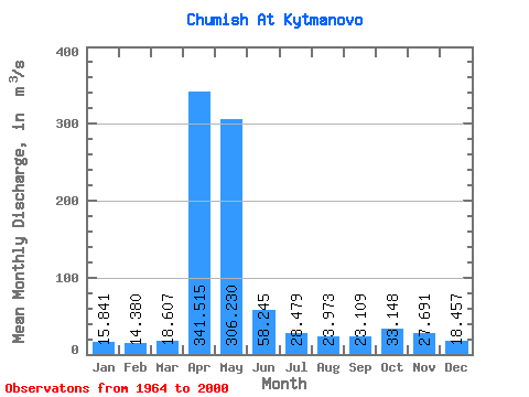
| Statistic | Jan | Feb | Mar | Apr | May | Jun | Jul | Aug | Sep | Oct | Nov | Dec | Annual |
|---|---|---|---|---|---|---|---|---|---|---|---|---|---|
| Mean | 15.84 | 14.38 | 18.61 | 341.51 | 306.23 | 58.24 | 28.48 | 23.97 | 23.11 | 33.15 | 27.69 | 18.46 | 75.81 |
| Standard Deviation | 5.59 | 4.75 | 11.91 | 121.59 | 220.63 | 32.86 | 12.60 | 13.98 | 11.54 | 16.34 | 14.32 | 8.19 | 20.93 |
| Min | 6.00 | 4.81 | 8.25 | 164.00 | 62.20 | 21.50 | 12.00 | 10.20 | 11.40 | 13.20 | 12.10 | 6.78 | 41.01 |
| Max | 27.80 | 23.60 | 78.60 | 613.00 | 1010.00 | 146.00 | 71.70 | 91.60 | 70.60 | 71.90 | 62.50 | 45.40 | 129.45 |
| Coefficient of Variation | 0.35 | 0.33 | 0.64 | 0.36 | 0.72 | 0.56 | 0.44 | 0.58 | 0.50 | 0.49 | 0.52 | 0.44 | 0.28 |
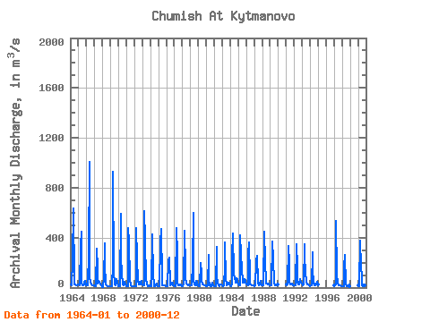
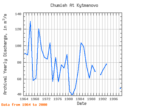
| Year | Jan | Feb | Mar | Apr | May | Jun | Jul | Aug | Sep | Oct | Nov | Dec | Annual | 1964 | 27.80 | 16.40 | 17.20 | 218.00 | 636.00 | 46.00 | 24.00 | 25.20 | 15.30 | 19.40 | 20.40 | 26.60 | 91.03 | 1965 | 26.60 | 21.70 | 21.10 | 337.00 | 450.00 | 35.80 | 19.20 | 15.60 | 26.60 | 42.30 | 50.50 | 19.40 | 88.82 | 1966 | 16.70 | 16.30 | 14.50 | 276.00 | 1010.00 | 91.60 | 42.00 | 23.10 | 16.80 | 16.20 | 14.80 | 15.40 | 129.45 | 1967 | 11.10 | 11.10 | 12.70 | 312.00 | 155.00 | 31.20 | 51.10 | 36.00 | 25.40 | 27.60 | 17.50 | 6.78 | 58.12 | 1968 | 6.00 | 4.81 | 78.60 | 357.00 | 181.00 | 26.80 | 14.50 | 13.00 | 11.90 | 13.20 | 13.30 | 11.20 | 60.94 | 1969 | 10.50 | 7.72 | 8.68 | 183.00 | 927.00 | 122.00 | 22.60 | 19.90 | 23.80 | 65.50 | 36.10 | 17.20 | 120.33 | 1970 | 12.70 | 13.00 | 13.80 | 593.00 | 242.00 | 114.00 | 23.80 | 25.80 | 17.80 | 46.60 | 24.50 | 13.50 | 95.04 | 1971 | 12.50 | 12.60 | 12.60 | 475.00 | 370.00 | 50.60 | 32.20 | 16.30 | 13.80 | 13.50 | 12.60 | 11.00 | 86.06 | 1972 | 8.75 | 7.86 | 11.00 | 479.00 | 236.00 | 49.90 | 43.40 | 26.60 | 24.90 | 41.20 | 51.00 | 28.10 | 83.98 | 1973 | 22.30 | 18.90 | 19.70 | 613.00 | 390.00 | 54.60 | 40.10 | 23.30 | 14.20 | 20.30 | 14.70 | 13.50 | 103.72 | 1974 | 11.20 | 8.94 | 10.70 | 424.00 | 104.00 | 24.90 | 12.00 | 10.20 | 16.00 | 33.40 | 16.70 | 11.60 | 56.97 | 1975 | 10.70 | 10.50 | 17.70 | 356.00 | 468.00 | 67.90 | 20.40 | 15.30 | 15.70 | 19.90 | 19.20 | 12.20 | 86.12 | 1976 | 11.50 | 11.00 | 11.00 | 215.00 | 238.00 | 26.10 | 16.30 | 28.60 | 40.40 | 41.00 | 21.20 | 18.10 | 56.52 | 1977 | 13.30 | 11.10 | 13.70 | 478.00 | 259.00 | 31.30 | 17.60 | 18.00 | 21.40 | 25.00 | 22.70 | 13.60 | 77.06 | 1978 | 13.00 | 12.20 | 25.60 | 454.00 | 156.00 | 72.90 | 31.50 | 28.60 | 18.70 | 23.50 | 23.90 | 17.20 | 73.09 | 1979 | 14.60 | 14.40 | 14.40 | 189.00 | 600.00 | 61.50 | 26.80 | 20.90 | 21.10 | 52.60 | 39.50 | 20.40 | 89.60 | 1980 | 17.30 | 13.50 | 13.50 | 200.00 | 108.00 | 55.90 | 27.30 | 22.60 | 17.40 | 20.50 | 20.70 | 15.70 | 44.37 | 1981 | 12.20 | 11.70 | 18.30 | 263.00 | 62.20 | 21.50 | 12.00 | 12.20 | 11.40 | 37.30 | 19.80 | 10.50 | 41.01 | 1982 | 9.00 | 8.31 | 8.25 | 324.00 | 96.40 | 28.70 | 17.10 | 15.10 | 11.80 | 26.10 | 27.70 | 18.30 | 49.23 | 1983 | 15.10 | 13.40 | 16.60 | 172.00 | 359.00 | 63.80 | 36.90 | 20.70 | 25.70 | 36.90 | 40.00 | 24.90 | 68.75 | 1984 | 14.60 | 12.20 | 30.80 | 255.00 | 437.00 | 110.00 | 71.70 | 91.60 | 38.70 | 71.90 | 62.50 | 45.40 | 103.45 | 1985 | 24.50 | 20.90 | 18.60 | 420.00 | 263.00 | 146.00 | 47.00 | 41.80 | 40.30 | 67.40 | 61.30 | 37.10 | 98.99 | 1986 | 25.60 | 22.70 | 20.10 | 266.00 | 365.00 | 72.40 | 25.70 | 26.90 | 20.40 | 21.40 | 16.40 | 15.00 | 74.80 | 1987 | 13.70 | 15.30 | 14.80 | 212.00 | 251.00 | 40.00 | 31.00 | 17.30 | 26.10 | 51.30 | 39.80 | 20.60 | 61.08 | 1988 | 21.20 | 17.40 | 16.00 | 447.00 | 213.00 | 45.80 | 28.90 | 32.30 | 24.60 | 32.00 | 25.30 | 19.50 | 76.92 | 1989 | 18.20 | 18.20 | 21.40 | 368.00 | 229.00 | 46.40 | 31.90 | 17.60 | 14.50 | 22.30 | 22.20 | 21.70 | 69.28 | 1991 | 21.80 | 23.60 | 22.60 | 330.00 | 196.00 | 43.20 | 26.60 | 22.90 | 24.20 | 35.20 | 20.00 | 18.80 | 65.41 | 1992 | 18.00 | 18.90 | 17.00 | 349.00 | 172.00 | 39.50 | 23.90 | 22.50 | 70.60 | 60.00 | 40.20 | 30.20 | 71.82 | 1993 | 21.40 | 20.90 | 22.80 | 348.00 | 250.00 | 122.00 | 36.30 | 27.80 | 26.80 | 28.00 | 16.40 | 12.30 | 77.72 | 1994 | 13.90 | 16.50 | 20.90 | 286.00 | 138.00 | 38.30 | 19.70 | 19.30 | 31.50 | 26.70 | 48.70 | 25.60 | 57.09 | 1997 | 21.10 | 18.70 | 23.30 | 534.00 | 112.00 | 33.10 | 22.00 | 20.70 | 21.00 | 19.00 | 12.10 | 10.50 | 70.62 | 1998 | 11.50 | 10.70 | 10.80 | 164.00 | 264.00 | 27.90 | 17.50 | 12.20 | 13.10 | 16.60 | 25.90 | 10.80 | 48.75 | 2000 | 14.40 | 13.10 | 15.30 | 373.00 | 168.00 | 80.50 | 26.80 | 21.20 | 20.70 | 20.10 | 16.20 | 16.40 | 65.47 |
|---|
 Return to R-Arctic Net Home Page