|
|
|||||||||||||||||
| Point ID: 6712 | Downloads | Plots | Site Data | Code: 10130 |
|
|
|||||||||||||||||
| Download | |
|---|---|
| Site Descriptor Information | Site Time Series Data |
| Link to all available data | |
|
|
| View: | Statistics | Time Series |
| Units: | mm |
| Statistic | Jan | Feb | Mar | Apr | May | Jun | Jul | Aug | Sep | Oct | Nov | Dec | Annual |
|---|---|---|---|---|---|---|---|---|---|---|---|---|---|
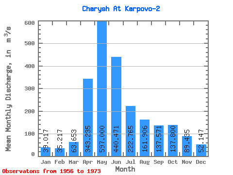
| Mean | 39.02 | 35.22 | 63.65 | 343.24 | 597.00 | 440.47 | 222.76 | 161.91 | 137.57 | 137.80 | 89.44 | 52.15 | 193.43 |
| Standard Deviation | 13.49 | 11.95 | 34.84 | 94.19 | 153.96 | 179.62 | 79.52 | 66.90 | 52.17 | 53.22 | 34.92 | 25.60 | 34.05 |
| Min | 23.50 | 16.70 | 23.20 | 171.00 | 331.00 | 165.00 | 122.00 | 68.10 | 77.10 | 68.20 | 34.40 | 23.90 | 141.12 |
| Max | 65.40 | 58.70 | 144.00 | 528.00 | 913.00 | 782.00 | 439.00 | 278.00 | 260.00 | 274.00 | 152.00 | 111.00 | 254.97 |
| Coefficient of Variation | 0.35 | 0.34 | 0.55 | 0.27 | 0.26 | 0.41 | 0.36 | 0.41 | 0.38 | 0.39 | 0.39 | 0.49 | 0.18 |
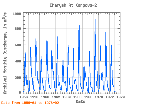
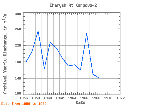
| Year | Jan | Feb | Mar | Apr | May | Jun | Jul | Aug | Sep | Oct | Nov | Dec | Annual | 1956 | 30.40 | 23.40 | 33.40 | 281.00 | 517.00 | 471.00 | 182.00 | 115.00 | 227.00 | 143.00 | 103.00 | 35.60 | 180.15 | 1957 | 25.20 | 25.30 | 51.30 | 272.00 | 576.00 | 514.00 | 251.00 | 235.00 | 112.00 | 187.00 | 143.00 | 65.20 | 204.75 | 1958 | 39.80 | 38.50 | 51.30 | 384.00 | 674.00 | 615.00 | 439.00 | 229.00 | 166.00 | 173.00 | 139.00 | 111.00 | 254.97 | 1959 | 62.30 | 53.10 | 51.70 | 362.00 | 458.00 | 331.00 | 212.00 | 152.00 | 103.00 | 90.10 | 49.30 | 38.40 | 163.57 | 1960 | 38.40 | 38.60 | 36.40 | 292.00 | 545.00 | 753.00 | 305.00 | 264.00 | 162.00 | 122.00 | 95.30 | 78.30 | 227.50 | 1961 | 65.40 | 58.70 | 69.30 | 528.00 | 506.00 | 331.00 | 275.00 | 278.00 | 183.00 | 142.00 | 72.50 | 52.50 | 213.45 | 1962 | 37.80 | 41.90 | 109.00 | 462.00 | 702.00 | 338.00 | 123.00 | 96.70 | 88.70 | 146.00 | 59.20 | 48.70 | 187.75 | 1963 | 47.70 | 43.70 | 121.00 | 171.00 | 409.00 | 405.00 | 159.00 | 135.00 | 130.00 | 159.00 | 152.00 | 104.00 | 169.70 | 1964 | 59.10 | 28.50 | 45.60 | 232.00 | 595.00 | 488.00 | 213.00 | 134.00 | 87.10 | 83.20 | 67.90 | 40.30 | 172.81 | 1965 | 34.40 | 35.40 | 49.80 | 264.00 | 561.00 | 207.00 | 122.00 | 135.00 | 173.00 | 175.00 | 92.80 | 66.70 | 159.68 | 1966 | 49.40 | 33.00 | 36.50 | 464.00 | 892.00 | 782.00 | 293.00 | 139.00 | 90.80 | 84.00 | 72.20 | 49.40 | 248.78 | 1967 | 29.60 | 22.60 | 66.30 | 327.00 | 331.00 | 165.00 | 209.00 | 271.00 | 141.00 | 127.00 | 69.10 | 39.50 | 149.84 | 1968 | 26.00 | 16.70 | 144.00 | 401.00 | 525.00 | 168.00 | 123.00 | 68.10 | 77.10 | 86.20 | 34.40 | 23.90 | 141.12 | 1969 | 24.30 | 22.60 | 23.20 | 313.00 | 913.00 | 542.00 | 207.00 | 94.60 | 140.00 | 274.00 | 118.00 | 26.90 | 224.88 | 1970 | 35.50 | 50.30 | 104.00 | 348.00 | 589.00 | 473.00 | 187.00 | 159.00 | 260.00 | 192.00 | 121.00 | 43.80 | 213.55 | 1971 | 47.80 | 45.70 | 55.60 | 443.00 | 757.00 | 526.00 | 226.00 | 137.00 | 90.00 | 68.20 | 58.70 | 24.20 | 206.60 | 1972 | 23.50 | 24.30 | 33.70 | 291.00 | 599.00 | 379.00 | 261.00 | 110.00 | 108.00 | 90.90 | 73.00 | 38.10 | 169.29 | 1973 | 25.70 | 31.60 |
|---|
 Return to R-Arctic Net Home Page