|
|
|||||||||||||||||
| Point ID: 6706 | Downloads | Plots | Site Data | Code: 10119 |
|
|
|||||||||||||||||
| Download | |
|---|---|
| Site Descriptor Information | Site Time Series Data |
| Link to all available data | |
| View: | Time Series | All |
| Units: | m3/s |
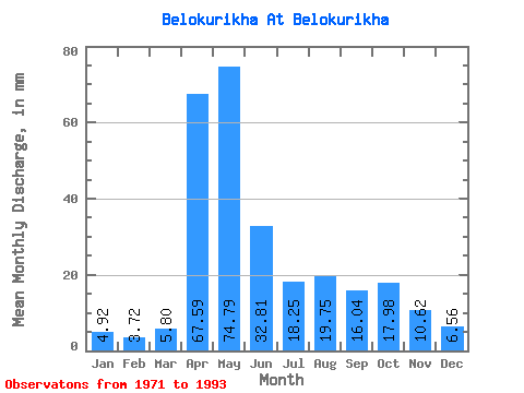
| Statistic | Jan | Feb | Mar | Apr | May | Jun | Jul | Aug | Sep | Oct | Nov | Dec | Annual |
|---|---|---|---|---|---|---|---|---|---|---|---|---|---|
| Mean | 4.91 | 3.75 | 5.79 | 67.61 | 74.79 | 32.82 | 18.26 | 19.74 | 16.02 | 17.99 | 10.64 | 6.57 | 278.39 |
| Standard Deviation | 1.46 | 0.93 | 2.07 | 27.55 | 36.52 | 22.74 | 14.60 | 17.82 | 13.57 | 11.41 | 4.99 | 2.89 | 95.24 |
| Min | 2.59 | 2.28 | 2.41 | 29.62 | 27.07 | 7.69 | 3.24 | 5.59 | 3.99 | 6.77 | 3.99 | 1.06 | 133.12 |
| Max | 7.95 | 5.63 | 10.30 | 125.61 | 152.15 | 113.36 | 64.15 | 67.98 | 52.70 | 51.21 | 22.50 | 13.24 | 516.38 |
| Coefficient of Variation | 0.30 | 0.25 | 0.36 | 0.41 | 0.49 | 0.69 | 0.80 | 0.90 | 0.85 | 0.63 | 0.47 | 0.44 | 0.34 |
 Return to R-Arctic Net Home Page