|
|
|||||||||||||||||
| Point ID: 669 | Downloads | Plots | Site Data | Code: 07BG004 |
|
|
|||||||||||||||||
| Download | |
|---|---|
| Site Descriptor Information | Site Time Series Data |
| Link to all available data | |
| View: | Time Series | All |
| Units: | m3/s |
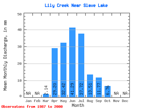
| Statistic | Jan | Feb | Mar | Apr | May | Jun | Jul | Aug | Sep | Oct | Nov | Dec | Annual |
|---|---|---|---|---|---|---|---|---|---|---|---|---|---|
| Mean | 2.15 | 29.24 | 32.37 | 41.25 | 37.69 | 13.47 | 11.75 | 6.72 | |||||
| Standard Deviation | 2.99 | 23.37 | 17.76 | 26.73 | 44.34 | 17.48 | 15.67 | 4.53 | |||||
| Min | 0.00 | 10.57 | 13.51 | 6.86 | 2.25 | 1.35 | 1.52 | 2.36 | |||||
| Max | 11.71 | 86.73 | 71.48 | 86.62 | 163.22 | 69.57 | 54.15 | 17.67 | |||||
| Coefficient of Variation | 1.39 | 0.80 | 0.55 | 0.65 | 1.18 | 1.30 | 1.33 | 0.67 |
 Return to R-Arctic Net Home Page