|
|
|||||||||||||||||
| Point ID: 6667 | Downloads | Plots | Site Data | Code: 10036 |
|
|
|||||||||||||||||
| Download | |
|---|---|
| Site Descriptor Information | Site Time Series Data |
| Link to all available data | |
|
|
| View: | Statistics | Time Series |
| Units: | mm |
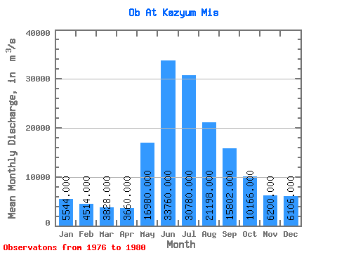
| Statistic | Jan | Feb | Mar | Apr | May | Jun | Jul | Aug | Sep | Oct | Nov | Dec | Annual |
|---|---|---|---|---|---|---|---|---|---|---|---|---|---|
| Mean | 5544.00 | 4514.00 | 3828.00 | 3660.00 | 16980.00 | 33760.00 | 30780.00 | 21198.00 | 15802.00 | 10166.00 | 6200.00 | 6106.00 | 13211.50 |
| Standard Deviation | 1174.32 | 700.31 | 321.67 | 289.05 | 4715.08 | 4803.44 | 8089.31 | 13343.65 | 10004.50 | 2858.61 | 1706.00 | 1099.49 | 3059.65 |
| Min | 4380.00 | 3800.00 | 3480.00 | 3420.00 | 10600.00 | 27600.00 | 19900.00 | 9590.00 | 8390.00 | 6760.00 | 4780.00 | 4910.00 | 10281.67 |
| Max | 6930.00 | 5370.00 | 4280.00 | 4060.00 | 23800.00 | 40300.00 | 40300.00 | 43400.00 | 33100.00 | 12600.00 | 9010.00 | 7510.00 | 18168.33 |
| Coefficient of Variation | 0.21 | 0.15 | 0.08 | 0.08 | 0.28 | 0.14 | 0.26 | 0.63 | 0.63 | 0.28 | 0.28 | 0.18 | 0.23 |
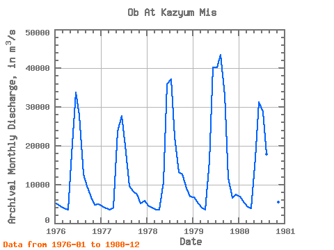
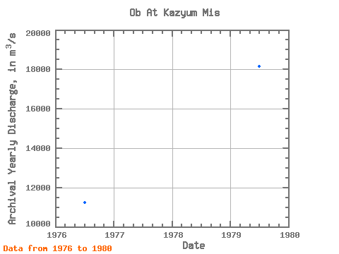
| Year | Jan | Feb | Mar | Apr | May | Jun | Jul | Aug | Sep | Oct | Nov | Dec | Annual | 1976 | 5140.00 | 4330.00 | 3870.00 | 3420.00 | 17800.00 | 33700.00 | 27800.00 | 12700.00 | 9620.00 | 6760.00 | 4780.00 | 4910.00 | 11235.83 | 1977 | 4380.00 | 3800.00 | 3480.00 | 4060.00 | 23800.00 | 27600.00 | 19900.00 | 9590.00 | 8390.00 | 7370.00 | 5140.00 | 5870.00 | 10281.67 | 1978 | 4620.00 | 3950.00 | 3560.00 | 3520.00 | 10600.00 | 36000.00 | 37100.00 | 22400.00 | 13200.00 | 12600.00 | 9010.00 | 6950.00 | 13625.83 | 1979 | 6650.00 | 5120.00 | 3950.00 | 3430.00 | 16000.00 | 40300.00 | 40300.00 | 43400.00 | 33100.00 | 11700.00 | 6560.00 | 7510.00 | 18168.33 | 1980 | 6930.00 | 5370.00 | 4280.00 | 3870.00 | 16700.00 | 31200.00 | 28800.00 | 17900.00 | 14700.00 | 12400.00 | 5510.00 | 5290.00 | 12745.83 |
|---|
 Return to R-Arctic Net Home Page