|
|
|||||||||||||||||
| Point ID: 6653 | Downloads | Plots | Site Data | Code: 9538 |
|
|
|||||||||||||||||
| Download | |
|---|---|
| Site Descriptor Information | Site Time Series Data |
| Link to all available data | |
|
|
| View: | Statistics | Time Series |
| Units: | mm |
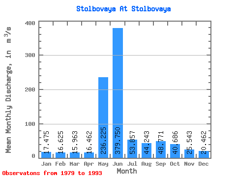
| Statistic | Jan | Feb | Mar | Apr | May | Jun | Jul | Aug | Sep | Oct | Nov | Dec | Annual |
|---|---|---|---|---|---|---|---|---|---|---|---|---|---|
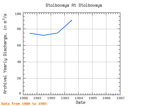
| Mean | 17.48 | 16.62 | 15.96 | 16.46 | 236.22 | 379.75 | 53.86 | 44.24 | 48.77 | 40.69 | 25.54 | 20.46 | 76.29 |
| Standard Deviation | 3.97 | 3.07 | 2.77 | 2.83 | 132.29 | 165.41 | 19.96 | 13.14 | 12.89 | 13.53 | 6.89 | 5.10 | 8.26 |
| Min | 13.10 | 14.20 | 13.10 | 12.60 | 42.00 | 222.00 | 32.30 | 34.10 | 31.10 | 24.70 | 15.80 | 14.30 | 66.12 |
| Max | 25.60 | 22.70 | 20.90 | 20.90 | 418.00 | 674.00 | 83.50 | 69.20 | 63.40 | 59.80 | 37.70 | 29.80 | 90.14 |
| Coefficient of Variation | 0.23 | 0.18 | 0.17 | 0.17 | 0.56 | 0.44 | 0.37 | 0.30 | 0.26 | 0.33 | 0.27 | 0.25 | 0.11 |
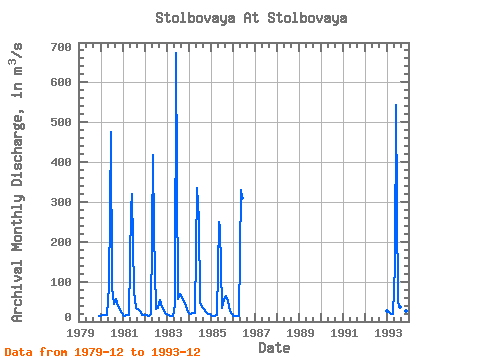
| Year | Jan | Feb | Mar | Apr | May | Jun | Jul | Aug | Sep | Oct | Nov | Dec | Annual | 1979 | 14.30 | 1980 | 14.60 | 15.20 | 15.30 | 15.60 | 88.80 | 476.00 | 83.50 | 44.60 | 55.80 | 37.70 | 27.70 | 20.60 | 74.62 | 1981 | 15.90 | 14.80 | 15.10 | 17.00 | 283.00 | 321.00 | 77.10 | 34.10 | 31.60 | 25.50 | 15.80 | 15.50 | 72.20 | 1982 | 15.30 | 15.10 | 14.90 | 17.60 | 418.00 | 222.00 | 32.30 | 34.40 | 53.60 | 35.30 | 25.30 | 19.10 | 75.24 | 1983 | 18.20 | 17.10 | 15.00 | 12.60 | 42.00 | 674.00 | 56.10 | 69.20 | 58.80 | 51.20 | 37.70 | 29.80 | 90.14 | 1984 | 20.40 | 19.70 | 20.90 | 20.90 | 336.00 | 256.00 | 48.90 | 36.20 | 31.10 | 24.70 | 19.60 | 19.80 | 71.18 | 1985 | 16.70 | 14.20 | 13.80 | 15.40 | 250.00 | 237.00 | 33.70 | 54.10 | 63.40 | 50.60 | 25.70 | 18.90 | 66.12 | 1986 | 13.10 | 14.20 | 13.10 | 13.30 | 330.00 | 309.00 | 1993 | 25.60 | 22.70 | 19.60 | 19.30 | 142.00 | 543.00 | 45.40 | 37.10 | 47.10 | 59.80 | 27.00 | 25.70 | 84.53 |
|---|
 Return to R-Arctic Net Home Page