|
|
|||||||||||||||||
| Point ID: 6612 | Downloads | Plots | Site Data | Code: 9386 |
|
|
|||||||||||||||||
| Download | |
|---|---|
| Site Descriptor Information | Site Time Series Data |
| Link to all available data | |
|
|
| View: | Statistics | Time Series |
| Units: | mm |
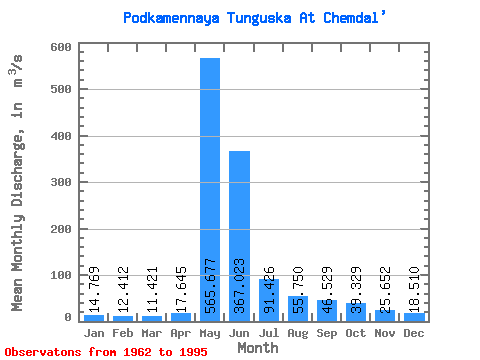
| Statistic | Jan | Feb | Mar | Apr | May | Jun | Jul | Aug | Sep | Oct | Nov | Dec | Annual |
|---|---|---|---|---|---|---|---|---|---|---|---|---|---|
| Mean | 14.77 | 12.41 | 11.42 | 17.64 | 565.68 | 367.02 | 91.43 | 55.75 | 46.53 | 39.33 | 25.65 | 18.51 | 106.05 |
| Standard Deviation | 5.49 | 4.55 | 4.66 | 16.01 | 146.17 | 199.99 | 59.31 | 34.55 | 22.76 | 19.10 | 12.17 | 7.19 | 22.64 |
| Min | 5.94 | 4.86 | 3.89 | 4.08 | 274.00 | 88.70 | 32.60 | 21.40 | 19.80 | 16.40 | 11.00 | 8.03 | 64.40 |
| Max | 28.20 | 22.80 | 23.80 | 88.50 | 791.00 | 1110.00 | 299.00 | 158.00 | 107.00 | 87.90 | 60.80 | 38.60 | 164.94 |
| Coefficient of Variation | 0.37 | 0.37 | 0.41 | 0.91 | 0.26 | 0.55 | 0.65 | 0.62 | 0.49 | 0.49 | 0.47 | 0.39 | 0.21 |
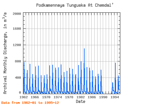
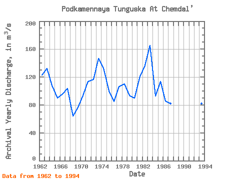
| Year | Jan | Feb | Mar | Apr | May | Jun | Jul | Aug | Sep | Oct | Nov | Dec | Annual | 1962 | 22.20 | 20.60 | 19.00 | 18.90 | 770.00 | 428.00 | 63.50 | 33.20 | 31.20 | 31.10 | 18.50 | 15.40 | 122.63 | 1963 | 15.80 | 14.50 | 14.50 | 15.00 | 427.00 | 574.00 | 175.00 | 92.90 | 89.30 | 87.90 | 44.40 | 38.60 | 132.41 | 1964 | 28.20 | 22.80 | 20.90 | 19.50 | 727.00 | 214.00 | 122.00 | 37.90 | 29.40 | 26.80 | 25.30 | 19.70 | 107.79 | 1965 | 16.00 | 13.00 | 11.50 | 13.00 | 476.00 | 264.00 | 62.90 | 44.30 | 77.10 | 53.80 | 31.10 | 20.70 | 90.28 | 1966 | 16.40 | 14.70 | 13.90 | 13.30 | 665.00 | 239.00 | 66.90 | 26.40 | 30.80 | 28.60 | 16.90 | 15.40 | 95.61 | 1967 | 13.00 | 11.30 | 10.50 | 88.50 | 682.00 | 132.00 | 69.20 | 55.00 | 78.10 | 56.10 | 26.20 | 20.60 | 103.54 | 1968 | 16.90 | 11.80 | 11.40 | 33.60 | 446.00 | 102.00 | 33.70 | 22.70 | 36.90 | 35.00 | 14.80 | 8.03 | 64.40 | 1969 | 5.94 | 4.86 | 3.89 | 4.08 | 301.00 | 447.00 | 65.00 | 21.40 | 19.80 | 19.30 | 11.00 | 9.39 | 76.06 | 1970 | 9.02 | 8.38 | 6.55 | 7.87 | 469.00 | 247.00 | 164.00 | 90.90 | 46.40 | 34.90 | 22.50 | 15.80 | 93.53 | 1971 | 10.70 | 9.91 | 7.70 | 11.10 | 693.00 | 186.00 | 79.60 | 78.80 | 107.00 | 87.60 | 60.80 | 35.10 | 113.94 | 1972 | 19.70 | 17.60 | 16.90 | 20.10 | 709.00 | 325.00 | 115.00 | 49.40 | 47.20 | 35.70 | 25.90 | 17.40 | 116.58 | 1973 | 14.60 | 13.40 | 12.20 | 12.30 | 634.00 | 534.00 | 216.00 | 158.00 | 62.00 | 44.30 | 29.40 | 26.40 | 146.38 | 1974 | 25.80 | 20.50 | 17.90 | 19.90 | 544.00 | 645.00 | 116.00 | 50.60 | 52.40 | 55.20 | 29.00 | 22.40 | 133.22 | 1975 | 20.00 | 18.40 | 16.60 | 21.10 | 711.00 | 188.00 | 63.30 | 47.90 | 41.00 | 33.10 | 19.50 | 16.50 | 99.70 | 1976 | 14.30 | 11.40 | 10.40 | 10.80 | 525.00 | 291.00 | 37.00 | 32.40 | 33.00 | 27.80 | 13.20 | 11.40 | 84.81 | 1977 | 9.04 | 5.75 | 4.69 | 8.10 | 559.00 | 479.00 | 49.50 | 33.00 | 51.60 | 29.40 | 27.40 | 19.60 | 106.34 | 1978 | 14.10 | 10.70 | 9.77 | 10.40 | 630.00 | 347.00 | 97.90 | 63.90 | 45.10 | 45.30 | 27.00 | 20.60 | 110.15 | 1979 | 13.70 | 10.30 | 9.58 | 10.70 | 606.00 | 343.00 | 36.00 | 26.00 | 25.50 | 21.00 | 13.00 | 11.20 | 93.83 | 1980 | 8.19 | 7.24 | 7.82 | 7.39 | 425.00 | 475.00 | 32.60 | 31.50 | 22.50 | 24.00 | 22.60 | 16.50 | 90.03 | 1981 | 15.90 | 13.60 | 9.41 | 51.50 | 701.00 | 88.70 | 299.00 | 125.00 | 73.10 | 41.90 | 18.80 | 13.20 | 120.93 | 1982 | 12.80 | 12.20 | 11.10 | 20.50 | 791.00 | 382.00 | 112.00 | 112.00 | 69.50 | 47.80 | 36.00 | 32.80 | 136.64 | 1983 | 27.50 | 20.80 | 23.80 | 26.10 | 397.00 | 1110.00 | 138.00 | 61.80 | 62.10 | 55.60 | 36.50 | 20.10 | 164.94 | 1984 | 14.80 | 12.70 | 11.00 | 13.10 | 649.00 | 249.00 | 38.60 | 33.80 | 32.20 | 24.90 | 19.90 | 18.00 | 93.08 | 1985 | 15.30 | 10.10 | 9.99 | 14.30 | 632.00 | 493.00 | 65.40 | 24.00 | 27.50 | 23.90 | 27.40 | 16.30 | 113.27 | 1986 | 12.10 | 10.50 | 9.34 | 9.43 | 567.00 | 289.00 | 33.00 | 29.70 | 27.70 | 16.40 | 11.80 | 11.90 | 85.66 | 1987 | 8.95 | 7.19 | 6.09 | 5.67 | 418.00 | 313.00 | 106.00 | 50.40 | 24.70 | 18.90 | 12.80 | 9.88 | 81.80 | 1988 | 8.90 | 7.65 | 7.49 | 9.06 | 483.00 | 380.00 | 70.50 | 79.00 | 32.40 | 30.50 | 19.70 | 16.60 | 95.40 | 1989 | 13.30 | 10.80 | 10.60 | 12.50 | 585.00 | 306.00 | 68.70 | 35.70 | 32.30 | 26.70 | 19.90 | 19.50 | 95.08 | 1993 | 11.80 | 11.10 | 12.40 | 15.70 | 274.00 | 250.00 | 77.50 | 101.00 | 78.70 | 80.90 | 59.50 | 15.80 | 82.37 | 1994 | 10.80 | 9.00 | 7.69 | 12.40 | 756.00 | 617.00 | 44.40 | 23.90 | 29.30 | 29.80 | 20.80 | 13.40 | 131.21 | 1995 | 12.10 | 12.00 | 9.45 | 11.10 | 284.00 | 440.00 | 116.00 | 26.60 | 45.00 | 33.60 | 25.60 |
|---|
 Return to R-Arctic Net Home Page