|
|
|||||||||||||||||
| Point ID: 6568 | Downloads | Plots | Site Data | Code: 9205 |
|
|
|||||||||||||||||
| Download | |
|---|---|
| Site Descriptor Information | Site Time Series Data |
| Link to all available data | |
|
|
| View: | Statistics | Time Series |
| Units: | mm |
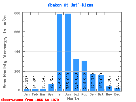
| Statistic | Jan | Feb | Mar | Apr | May | Jun | Jul | Aug | Sep | Oct | Nov | Dec | Annual |
|---|---|---|---|---|---|---|---|---|---|---|---|---|---|
| Mean | 24.07 | 19.65 | 19.14 | 73.72 | 779.00 | 785.00 | 324.00 | 308.00 | 177.75 | 165.00 | 47.97 | 28.73 | 224.56 |
| Standard Deviation | 3.43 | 6.05 | 7.91 | 28.28 | 254.53 | 386.35 | 132.46 | 204.75 | 63.46 | 85.35 | 16.35 | 6.63 | 52.22 |
| Min | 20.10 | 16.00 | 9.86 | 37.60 | 532.00 | 315.00 | 158.00 | 201.00 | 104.00 | 107.00 | 34.10 | 21.10 | 168.90 |
| Max | 27.90 | 28.70 | 29.00 | 103.00 | 1160.00 | 1360.00 | 474.00 | 615.00 | 258.00 | 263.00 | 66.00 | 33.10 | 272.47 |
| Coefficient of Variation | 0.14 | 0.31 | 0.41 | 0.38 | 0.33 | 0.49 | 0.41 | 0.67 | 0.36 | 0.52 | 0.34 | 0.23 | 0.23 |
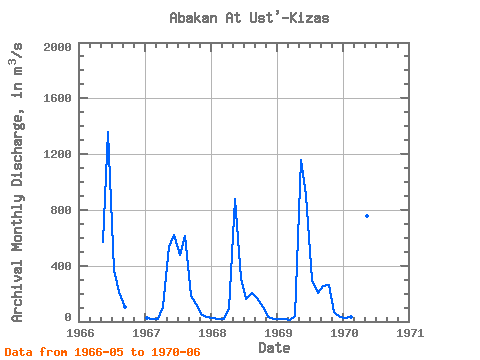
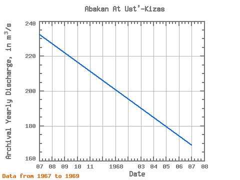
| Year | Jan | Feb | Mar | Apr | May | Jun | Jul | Aug | Sep | Oct | Nov | Dec | Annual | 1966 | 571.00 | 1360.00 | 367.00 | 214.00 | 104.00 | 1967 | 22.60 | 16.80 | 17.40 | 103.00 | 532.00 | 622.00 | 474.00 | 615.00 | 184.00 | 125.00 | 43.80 | 32.00 | 232.30 | 1968 | 25.70 | 17.10 | 20.30 | 87.50 | 875.00 | 315.00 | 158.00 | 201.00 | 165.00 | 107.00 | 34.10 | 21.10 | 168.90 | 1969 | 20.10 | 16.00 | 9.86 | 37.60 | 1160.00 | 907.00 | 297.00 | 202.00 | 258.00 | 263.00 | 66.00 | 33.10 | 272.47 | 1970 | 27.90 | 28.70 | 29.00 | 66.80 | 757.00 | 721.00 |
|---|
 Return to R-Arctic Net Home Page