|
|
|||||||||||||||||
| Point ID: 6556 | Downloads | Plots | Site Data | Code: 9130 |
|
|
|||||||||||||||||
| Download | |
|---|---|
| Site Descriptor Information | Site Time Series Data |
| Link to all available data | |
| View: | Time Series | All |
| Units: | m3/s |
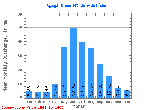
| Statistic | Jan | Feb | Mar | Apr | May | Jun | Jul | Aug | Sep | Oct | Nov | Dec | Annual |
|---|---|---|---|---|---|---|---|---|---|---|---|---|---|
| Mean | 5.26 | 4.20 | 4.49 | 9.76 | 35.70 | 50.43 | 39.54 | 35.67 | 24.06 | 15.41 | 7.04 | 6.04 | 231.87 |
| Standard Deviation | 0.93 | 0.80 | 0.82 | 10.90 | 13.50 | 13.61 | 11.79 | 8.74 | 4.79 | 3.30 | 1.79 | 1.16 | 35.06 |
| Min | 2.73 | 2.29 | 2.23 | 4.03 | 19.62 | 24.38 | 23.73 | 19.22 | 15.53 | 11.32 | 3.82 | 3.00 | 163.57 |
| Max | 6.66 | 5.63 | 5.94 | 55.95 | 70.66 | 80.71 | 70.66 | 50.38 | 34.13 | 25.98 | 10.33 | 8.14 | 313.67 |
| Coefficient of Variation | 0.18 | 0.19 | 0.18 | 1.12 | 0.38 | 0.27 | 0.30 | 0.24 | 0.20 | 0.21 | 0.25 | 0.19 | 0.15 |
 Return to R-Arctic Net Home Page