|
|
|||||||||||||||||
| Point ID: 6550 | Downloads | Plots | Site Data | Code: 9118 |
|
|
|||||||||||||||||
| Download | |
|---|---|
| Site Descriptor Information | Site Time Series Data |
| Link to all available data | |
|
|
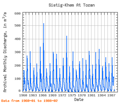
| View: | Statistics | Time Series |
| Units: | mm |
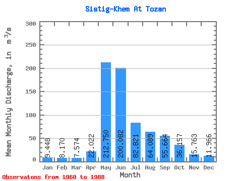
| Statistic | Jan | Feb | Mar | Apr | May | Jun | Jul | Aug | Sep | Oct | Nov | Dec | Annual |
|---|---|---|---|---|---|---|---|---|---|---|---|---|---|
| Mean | 9.45 | 8.17 | 7.57 | 22.02 | 212.75 | 200.08 | 82.82 | 64.09 | 55.66 | 36.16 | 15.76 | 11.97 | 60.51 |
| Standard Deviation | 4.20 | 3.88 | 2.94 | 16.01 | 56.10 | 107.02 | 29.62 | 23.12 | 25.04 | 18.15 | 6.86 | 4.98 | 12.97 |
| Min | 2.32 | 1.60 | 1.83 | 2.99 | 139.00 | 67.40 | 34.20 | 24.40 | 27.20 | 16.50 | 4.30 | 2.29 | 39.04 |
| Max | 18.40 | 18.10 | 14.10 | 67.00 | 338.00 | 514.00 | 135.00 | 125.00 | 136.00 | 110.00 | 28.10 | 21.10 | 88.78 |
| Coefficient of Variation | 0.44 | 0.47 | 0.39 | 0.73 | 0.26 | 0.54 | 0.36 | 0.36 | 0.45 | 0.50 | 0.43 | 0.42 | 0.21 |
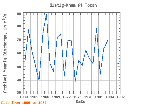
| Year | Jan | Feb | Mar | Apr | May | Jun | Jul | Aug | Sep | Oct | Nov | Dec | Annual | 1960 | 10.50 | 9.72 | 9.29 | 13.60 | 162.00 | 158.00 | 61.40 | 79.60 | 84.30 | 30.80 | 13.30 | 13.80 | 53.86 | 1961 | 10.90 | 9.57 | 9.10 | 39.20 | 271.00 | 234.00 | 112.00 | 57.80 | 86.60 | 48.60 | 25.60 | 21.10 | 77.12 | 1962 | 18.40 | 18.10 | 14.00 | 24.40 | 305.00 | 128.00 | 83.50 | 44.80 | 38.20 | 37.30 | 13.20 | 9.85 | 61.23 | 1963 | 11.40 | 10.30 | 8.68 | 11.50 | 140.00 | 182.00 | 74.80 | 53.10 | 45.30 | 30.20 | 21.70 | 18.40 | 50.62 | 1964 | 11.80 | 9.00 | 8.72 | 14.40 | 212.00 | 82.30 | 34.20 | 34.50 | 29.50 | 16.50 | 10.90 | 11.50 | 39.61 | 1965 | 10.50 | 9.65 | 8.67 | 9.91 | 338.00 | 123.00 | 76.40 | 79.80 | 136.00 | 55.00 | 27.40 | 19.90 | 74.52 | 1966 | 14.50 | 10.70 | 9.71 | 11.90 | 221.00 | 514.00 | 109.00 | 78.00 | 45.40 | 27.60 | 11.70 | 11.80 | 88.78 | 1967 | 7.12 | 7.91 | 7.29 | 55.00 | 176.00 | 117.00 | 97.70 | 56.60 | 50.70 | 33.70 | 10.60 | 10.40 | 52.50 | 1968 | 8.45 | 7.40 | 8.18 | 30.30 | 213.00 | 93.70 | 39.80 | 56.70 | 61.40 | 26.70 | 5.81 | 3.22 | 46.22 | 1969 | 2.45 | 1.60 | 6.11 | 17.30 | 301.00 | 276.00 | 59.90 | 58.10 | 59.20 | 42.20 | 18.90 | 15.60 | 71.53 | 1970 | 12.80 | 11.20 | 9.51 | 11.30 | 214.00 | 286.00 | 120.00 | 82.40 | 68.90 | 50.60 | 13.20 | 10.90 | 74.23 | 1971 | 7.26 | 6.67 | 6.60 | 37.10 | 178.00 | 89.60 | 70.70 | 45.90 | 30.80 | 18.00 | 13.20 | 11.60 | 42.95 | 1972 | 6.57 | 5.28 | 4.85 | 67.00 | 139.00 | 254.00 | 135.00 | 76.90 | 70.40 | 36.70 | 22.40 | 16.40 | 69.54 | 1973 | 12.40 | 9.85 | 9.01 | 16.50 | 167.00 | 421.00 | 93.10 | 43.30 | 27.20 | 16.60 | 5.83 | 6.93 | 69.06 | 1974 | 5.47 | 2.96 | 3.30 | 40.70 | 190.00 | 103.00 | 38.90 | 24.40 | 28.80 | 19.20 | 6.48 | 5.30 | 39.04 | 1975 | 4.62 | 4.44 | 4.26 | 4.07 | 160.00 | 303.00 | 55.60 | 38.70 | 44.70 | 21.20 | 8.63 | 5.13 | 54.53 | 1976 | 2.32 | 1.75 | 1.83 | 2.99 | 167.00 | 142.00 | 110.00 | 105.00 | 49.10 | 23.30 | 4.30 | 2.29 | 50.99 | 1977 | 2.84 | 2.80 | 3.10 | 15.00 | 190.00 | 228.00 | 130.00 | 60.80 | 45.60 | 36.40 | 19.00 | 13.30 | 62.24 | 1978 | 8.48 | 6.81 | 6.28 | 11.40 | 166.00 | 252.00 | 60.00 | 74.20 | 35.80 | 24.50 | 12.30 | 10.40 | 55.68 | 1979 | 9.46 | 8.39 | 7.53 | 10.70 | 239.00 | 170.00 | 41.00 | 32.70 | 55.20 | 31.20 | 15.70 | 6.61 | 52.29 | 1980 | 3.86 | 3.57 | 3.86 | 13.70 | 307.00 | 249.00 | 101.00 | 125.00 | 72.50 | 35.90 | 15.70 | 11.30 | 78.53 | 1981 | 8.78 | 7.40 | 7.15 | 37.40 | 203.00 | 67.40 | 47.90 | 43.00 | 55.50 | 31.10 | 14.30 | 7.32 | 44.19 | 1982 | 4.84 | 4.45 | 5.58 | 46.30 | 298.00 | 124.00 | 70.10 | 69.90 | 37.40 | 50.10 | 28.10 | 16.40 | 62.93 | 1983 | 13.80 | 11.90 | 10.20 | 15.60 | 169.00 | 321.00 | 84.80 | 63.20 | 47.00 | 50.30 | 26.00 | 15.90 | 69.06 | 1984 | 12.90 | 12.00 | 10.80 | 12.50 | 169.00 | 193.00 | 119.00 | 73.90 | 38.20 | 42.80 | 24.70 | 16.50 | 60.44 | 1985 | 14.40 | 14.00 | 14.10 | 15.40 | 189.00 | 260.00 | 117.00 | 89.20 | 112.00 | 36.70 | 18.30 | 17.80 | 74.83 | 1986 | 13.40 | 8.94 | 7.50 | 9.15 | 214.00 | 92.30 | 80.40 | 94.10 | 53.80 | 29.20 | 13.90 | 11.20 | 52.32 | 1987 | 9.16 | 7.26 | 6.86 | 22.30 | 259.00 | 139.00 | 95.80 | 52.90 | 49.10 | 110.00 | 20.20 | 14.20 | 65.48 | 1988 | 14.60 | 13.30 |
|---|
 Return to R-Arctic Net Home Page