|
|
|||||||||||||||||
| Point ID: 6545 | Downloads | Plots | Site Data | Code: 9097 |
|
|
|||||||||||||||||
| Download | |
|---|---|
| Site Descriptor Information | Site Time Series Data |
| Link to all available data | |
|
|
| View: | Statistics | Time Series |
| Units: | mm |
| Statistic | Jan | Feb | Mar | Apr | May | Jun | Jul | Aug | Sep | Oct | Nov | Dec | Annual |
|---|---|---|---|---|---|---|---|---|---|---|---|---|---|
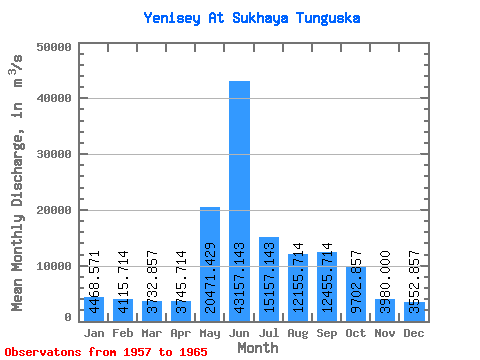
| Mean | 4468.57 | 4115.71 | 3732.86 | 3745.71 | 20471.43 | 43157.14 | 15157.14 | 12155.71 | 12455.71 | 9702.86 | 3980.00 | 3552.86 | 11391.31 |
| Standard Deviation | 435.37 | 305.17 | 444.25 | 624.79 | 5619.82 | 8946.85 | 2684.43 | 2694.77 | 1638.72 | 1338.89 | 720.69 | 638.74 | 1058.74 |
| Min | 4030.00 | 3710.00 | 3030.00 | 2880.00 | 12900.00 | 32900.00 | 11700.00 | 9460.00 | 9690.00 | 8040.00 | 3020.00 | 2650.00 | 9940.83 |
| Max | 5330.00 | 4640.00 | 4170.00 | 4400.00 | 27300.00 | 60100.00 | 18900.00 | 17400.00 | 15100.00 | 12300.00 | 4800.00 | 4400.00 | 12590.00 |
| Coefficient of Variation | 0.10 | 0.07 | 0.12 | 0.17 | 0.28 | 0.21 | 0.18 | 0.22 | 0.13 | 0.14 | 0.18 | 0.18 | 0.09 |
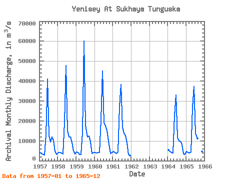
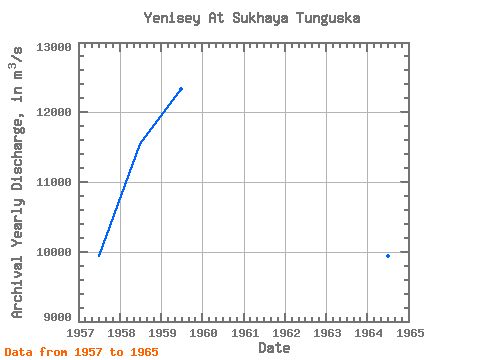
| Year | Jan | Feb | Mar | Apr | May | Jun | Jul | Aug | Sep | Oct | Nov | Dec | Annual | 1957 | 4030.00 | 3710.00 | 3030.00 | 2880.00 | 12900.00 | 40900.00 | 12600.00 | 9460.00 | 11900.00 | 10100.00 | 4750.00 | 3090.00 | 9945.83 | 1958 | 4210.00 | 4080.00 | 3790.00 | 3330.00 | 19200.00 | 47700.00 | 14900.00 | 11900.00 | 12000.00 | 9240.00 | 4800.00 | 3420.00 | 11547.50 | 1959 | 4320.00 | 4200.00 | 3250.00 | 3190.00 | 14100.00 | 60100.00 | 17700.00 | 11800.00 | 12400.00 | 9350.00 | 3570.00 | 4040.00 | 12335.00 | 1960 | 4190.00 | 3800.00 | 4170.00 | 4250.00 | 20500.00 | 45000.00 | 18900.00 | 17400.00 | 15100.00 | 10000.00 | 3670.00 | 4100.00 | 12590.00 | 1961 | 4630.00 | 4180.00 | 3720.00 | 4400.00 | 27300.00 | 38200.00 | 16600.00 | 13600.00 | 12700.00 | 8890.00 | 3020.00 | 2650.00 | 11657.50 | 1964 | 5330.00 | 4640.00 | 4170.00 | 3770.00 | 22600.00 | 32900.00 | 11700.00 | 9830.00 | 9690.00 | 8040.00 | 3450.00 | 3170.00 | 9940.83 | 1965 | 4570.00 | 4200.00 | 4000.00 | 4400.00 | 26700.00 | 37300.00 | 13700.00 | 11100.00 | 13400.00 | 12300.00 | 4600.00 | 4400.00 | 11722.50 |
|---|
 Return to R-Arctic Net Home Page