|
|
|||||||||||||||||
| Point ID: 6488 | Downloads | Plots | Site Data | Code: 8251 |
|
|
|||||||||||||||||
| Download | |
|---|---|
| Site Descriptor Information | Site Time Series Data |
| Link to all available data | |
| View: | Time Series | All |
| Units: | mm |
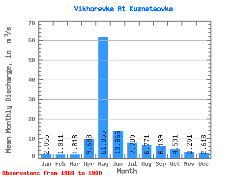
| Statistic | Jan | Feb | Mar | Apr | May | Jun | Jul | Aug | Sep | Oct | Nov | Dec | Annual |
|---|---|---|---|---|---|---|---|---|---|---|---|---|---|
| Mean | 2.06 | 1.81 | 1.82 | 9.69 | 61.85 | 13.87 | 7.78 | 6.77 | 6.14 | 4.53 | 3.20 | 2.62 | 10.06 |
| Standard Deviation | 1.04 | 1.13 | 1.10 | 8.39 | 21.43 | 5.33 | 3.74 | 3.88 | 3.79 | 2.16 | 1.27 | 0.99 | 2.43 |
| Min | 0.97 | 0.59 | 0.37 | 1.78 | 26.80 | 5.80 | 3.45 | 2.54 | 3.01 | 1.85 | 1.93 | 1.33 | 5.89 |
| Max | 4.70 | 4.77 | 4.46 | 34.80 | 103.00 | 27.80 | 16.10 | 17.10 | 17.70 | 10.60 | 8.12 | 4.71 | 15.52 |
| Coefficient of Variation | 0.51 | 0.62 | 0.61 | 0.87 | 0.35 | 0.39 | 0.48 | 0.57 | 0.62 | 0.48 | 0.40 | 0.38 | 0.24 |
 Return to R-Arctic Net Home Page