|
|
|||||||||||||||||
| Point ID: 6488 | Downloads | Plots | Site Data | Code: 8251 |
|
|
|||||||||||||||||
| Download | |
|---|---|
| Site Descriptor Information | Site Time Series Data |
| Link to all available data | |
| View: | Time Series | All |
| Units: | m3/s |
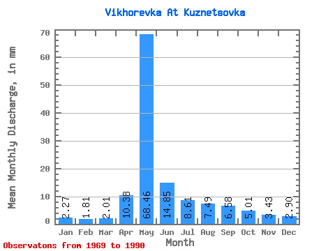
| Statistic | Jan | Feb | Mar | Apr | May | Jun | Jul | Aug | Sep | Oct | Nov | Dec | Annual |
|---|---|---|---|---|---|---|---|---|---|---|---|---|---|
| Mean | 2.27 | 1.83 | 2.01 | 10.38 | 68.45 | 14.85 | 8.61 | 7.49 | 6.58 | 5.01 | 3.43 | 2.90 | 131.20 |
| Standard Deviation | 1.15 | 1.14 | 1.22 | 8.99 | 23.71 | 5.71 | 4.14 | 4.30 | 4.06 | 2.39 | 1.36 | 1.10 | 31.69 |
| Min | 1.07 | 0.59 | 0.41 | 1.91 | 29.66 | 6.21 | 3.82 | 2.81 | 3.22 | 2.05 | 2.07 | 1.47 | 76.77 |
| Max | 5.20 | 4.81 | 4.94 | 37.27 | 113.98 | 29.78 | 17.82 | 18.92 | 18.96 | 11.73 | 8.70 | 5.21 | 202.34 |
| Coefficient of Variation | 0.51 | 0.62 | 0.61 | 0.87 | 0.35 | 0.39 | 0.48 | 0.57 | 0.62 | 0.48 | 0.40 | 0.38 | 0.24 |
 Return to R-Arctic Net Home Page