|
|
|||||||||||||||||
| Point ID: 6467 | Downloads | Plots | Site Data | Code: 8155 |
|
|
|||||||||||||||||
| Download | |
|---|---|
| Site Descriptor Information | Site Time Series Data |
| Link to all available data | |
|
|
| View: | Statistics | Time Series |
| Units: | mm |
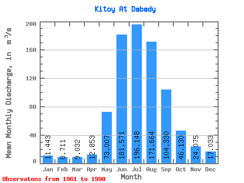
| Statistic | Jan | Feb | Mar | Apr | May | Jun | Jul | Aug | Sep | Oct | Nov | Dec | Annual |
|---|---|---|---|---|---|---|---|---|---|---|---|---|---|
| Mean | 11.44 | 8.71 | 9.03 | 12.85 | 73.01 | 181.57 | 196.15 | 171.66 | 104.33 | 46.13 | 24.07 | 17.03 | 69.91 |
| Standard Deviation | 2.72 | 1.50 | 1.30 | 4.22 | 23.75 | 52.55 | 41.77 | 46.67 | 26.85 | 8.90 | 4.70 | 3.49 | 9.88 |
| Min | 6.70 | 5.47 | 6.24 | 6.93 | 27.00 | 104.00 | 117.00 | 99.60 | 70.60 | 30.20 | 16.10 | 11.50 | 53.35 |
| Max | 16.70 | 11.30 | 12.90 | 24.30 | 119.00 | 309.00 | 296.00 | 309.00 | 175.00 | 61.40 | 35.10 | 22.80 | 86.83 |
| Coefficient of Variation | 0.24 | 0.17 | 0.14 | 0.33 | 0.33 | 0.29 | 0.21 | 0.27 | 0.26 | 0.19 | 0.20 | 0.20 | 0.14 |
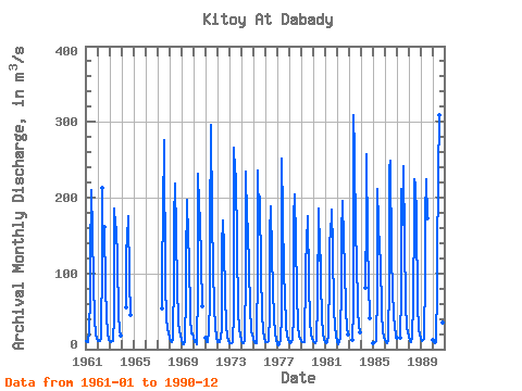
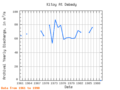
| Year | Jan | Feb | Mar | Apr | May | Jun | Jul | Aug | Sep | Oct | Nov | Dec | Annual | 1961 | 10.90 | 8.74 | 9.62 | 24.30 | 70.80 | 120.00 | 210.00 | 154.00 | 87.60 | 40.50 | 18.70 | 14.50 | 64.14 | 1962 | 11.10 | 10.10 | 10.40 | 13.90 | 119.00 | 213.00 | 162.00 | 80.50 | 44.00 | 20.10 | 11.50 | 1963 | 10.20 | 9.88 | 10.10 | 11.10 | 42.00 | 186.00 | 163.00 | 161.00 | 116.00 | 46.10 | 23.40 | 18.30 | 66.42 | 1964 | 55.90 | 131.00 | 144.00 | 175.00 | 93.10 | 45.60 | 1967 | 53.50 | 104.00 | 180.00 | 276.00 | 84.90 | 42.00 | 26.30 | 20.20 | 1968 | 14.70 | 11.10 | 9.46 | 12.60 | 97.60 | 172.00 | 218.00 | 152.00 | 82.30 | 36.80 | 24.10 | 19.20 | 70.82 | 1969 | 11.80 | 6.20 | 6.24 | 11.00 | 72.10 | 114.00 | 197.00 | 146.00 | 119.00 | 41.80 | 21.10 | 21.10 | 63.95 | 1970 | 16.10 | 8.72 | 9.37 | 6.93 | 79.10 | 232.00 | 190.00 | 172.00 | 116.00 | 56.60 | 1971 | 14.70 | 9.32 | 9.32 | 23.10 | 65.80 | 151.00 | 296.00 | 174.00 | 107.00 | 55.50 | 28.80 | 14.40 | 79.08 | 1972 | 9.07 | 8.75 | 9.78 | 15.00 | 27.00 | 135.00 | 170.00 | 133.00 | 72.80 | 30.50 | 17.20 | 12.10 | 53.35 | 1973 | 7.41 | 7.48 | 8.33 | 8.98 | 47.60 | 266.00 | 234.00 | 229.00 | 137.00 | 50.50 | 25.90 | 19.80 | 86.83 | 1974 | 11.50 | 7.64 | 7.73 | 12.90 | 101.00 | 234.00 | 173.00 | 159.00 | 105.00 | 56.80 | 23.80 | 19.30 | 75.97 | 1975 | 13.30 | 8.79 | 8.20 | 7.83 | 113.00 | 236.00 | 173.00 | 202.00 | 99.10 | 47.80 | 23.70 | 16.60 | 79.11 | 1976 | 9.63 | 8.91 | 9.05 | 10.60 | 45.10 | 151.00 | 189.00 | 124.00 | 80.00 | 41.00 | 22.90 | 12.60 | 58.65 | 1977 | 6.70 | 5.47 | 7.05 | 11.60 | 45.20 | 251.00 | 177.00 | 99.60 | 70.60 | 30.30 | 18.40 | 11.70 | 61.22 | 1978 | 8.97 | 8.44 | 8.68 | 11.50 | 44.70 | 174.00 | 205.00 | 143.00 | 73.80 | 30.20 | 16.10 | 14.00 | 61.53 | 1979 | 10.20 | 9.36 | 9.34 | 9.24 | 99.10 | 111.00 | 140.00 | 175.00 | 87.00 | 37.40 | 19.30 | 13.70 | 60.05 | 1980 | 10.10 | 8.73 | 7.96 | 10.50 | 64.30 | 186.00 | 117.00 | 158.00 | 89.00 | 41.70 | 20.00 | 13.70 | 60.58 | 1981 | 9.97 | 7.93 | 10.00 | 18.30 | 98.90 | 146.00 | 149.00 | 184.00 | 133.00 | 53.20 | 28.80 | 18.20 | 71.44 | 1982 | 10.90 | 6.29 | 9.55 | 14.70 | 87.70 | 151.00 | 195.00 | 143.00 | 108.00 | 52.60 | 27.40 | 19.80 | 68.83 | 1983 | 12.10 | 52.90 | 309.00 | 261.00 | 149.00 | 123.00 | 51.40 | 31.10 | 22.80 | 1984 | 81.30 | 175.00 | 257.00 | 144.00 | 87.20 | 40.80 | 1985 | 7.88 | 7.97 | 8.82 | 10.40 | 77.50 | 211.00 | 167.00 | 130.00 | 119.00 | 46.70 | 23.60 | 15.10 | 68.75 | 1986 | 11.60 | 9.00 | 8.35 | 10.20 | 91.90 | 237.00 | 249.00 | 123.00 | 77.00 | 47.10 | 28.00 | 19.10 | 75.94 | 1987 | 15.40 | 15.10 | 72.40 | 211.00 | 164.00 | 241.00 | 142.00 | 61.40 | 28.10 | 21.80 | 1988 | 16.70 | 11.20 | 9.17 | 16.40 | 60.20 | 182.00 | 225.00 | 216.00 | 175.00 | 60.10 | 25.90 | 19.70 | 84.78 | 1989 | 13.80 | 11.30 | 12.90 | 13.60 | 96.30 | 176.00 | 224.00 | 173.00 | 1990 | 12.00 | 9.03 | 8.31 | 9.45 | 82.30 | 119.00 | 229.00 | 309.00 | 152.00 | 57.10 | 35.10 | 19.60 | 86.82 |
|---|
 Return to R-Arctic Net Home Page